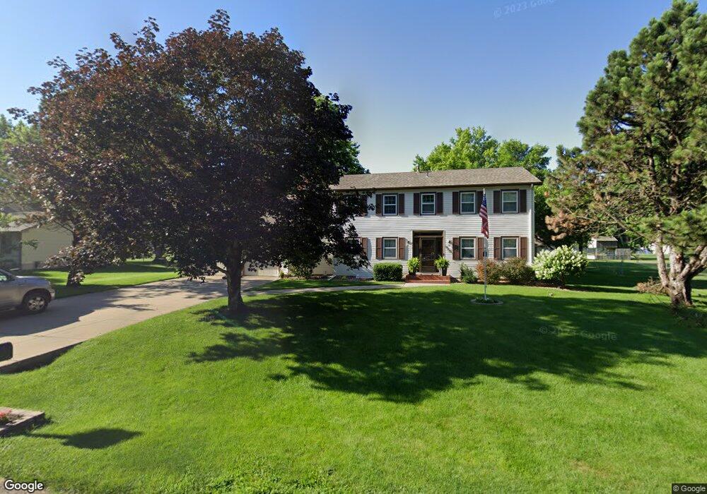
4233 Kay Ave Grand Island, NE 68803
Estimated Value: $339,371 - $403,000
4
Beds
3
Baths
2,287
Sq Ft
$163/Sq Ft
Est. Value
About This Home
This home is located at 4233 Kay Ave, Grand Island, NE 68803 and is currently estimated at $372,843, approximately $163 per square foot. 4233 Kay Ave is a home located in Hall County with nearby schools including Engleman Elementary School, Westridge Middle School, and Grand Island Senior High School.
Ownership History
Date
Name
Owned For
Owner Type
Purchase Details
Closed on
Oct 1, 2012
Sold by
Raschko Michael F and Raschko Laurine R
Bought by
Splattstoesser Travis and Splattstoesser Ashley
Current Estimated Value
Home Financials for this Owner
Home Financials are based on the most recent Mortgage that was taken out on this home.
Original Mortgage
$199,813
Outstanding Balance
$138,625
Interest Rate
3.55%
Mortgage Type
FHA
Estimated Equity
$234,218
Create a Home Valuation Report for This Property
The Home Valuation Report is an in-depth analysis detailing your home's value as well as a comparison with similar homes in the area
Home Values in the Area
Average Home Value in this Area
Purchase History
| Date | Buyer | Sale Price | Title Company |
|---|---|---|---|
| Splattstoesser Travis | $171,000 | None Available |
Source: Public Records
Mortgage History
| Date | Status | Borrower | Loan Amount |
|---|---|---|---|
| Open | Splattstoesser Travis | $199,813 |
Source: Public Records
Tax History Compared to Growth
Tax History
| Year | Tax Paid | Tax Assessment Tax Assessment Total Assessment is a certain percentage of the fair market value that is determined by local assessors to be the total taxable value of land and additions on the property. | Land | Improvement |
|---|---|---|---|---|
| 2024 | $4,385 | $301,002 | $44,658 | $256,344 |
| 2023 | $5,366 | $295,297 | $44,658 | $250,639 |
| 2022 | $4,894 | $243,543 | $20,927 | $222,616 |
| 2021 | $4,967 | $243,543 | $20,927 | $222,616 |
| 2020 | $4,882 | $243,543 | $20,927 | $222,616 |
| 2019 | $4,917 | $233,230 | $20,927 | $212,303 |
| 2017 | $4,830 | $223,120 | $20,927 | $202,193 |
| 2016 | $4,444 | $213,289 | $20,927 | $192,362 |
| 2015 | $4,036 | $190,746 | $20,927 | $169,819 |
| 2014 | $3,661 | $166,739 | $20,927 | $145,812 |
Source: Public Records
Map
Nearby Homes
- 2110 Topeka Cir
- 4204 W Capital Ave
- 2203 Macron St
- 4242 Spur Ln
- 4019 Sacramento Cir
- 4011 Sacramento Cir
- 4128 Allen Ave
- 4121 Allen Ave
- 1429 Mansfield Rd
- 4306 Saddle Horse Ct
- 3920 Majestic Ave
- 1604 Meadow Rd
- 3814 Majestic Ave
- 3804 Norseman Ave
- 629 N White
- 2931 Lee St
- 4048 Northview Dr
- 4243 Amble Way
- 4233 Amble Way
- 4223 Amble Way
- 4227 Kay Ave
- 4239 Kay Ave
- 4234 Norseman Ave
- 4240 Norseman Ave
- 4228 Norseman Ave
- 4234 Kay Ave
- 4221 Kay Ave
- 4247 Kay Ave
- 4228 Kay Ave
- 4246 Norseman Ave
- 4222 Norseman Ave
- 4241 Nordic Rd
- 4222 Kay Ave
- 4215 Kay Ave
- 2217 Viking Rd
- 4216 Norseman Ave
- 4233 Norseman Ave
- 2225 Viking Rd
- 2209 Viking Rd
- 4239 Norseman Ave