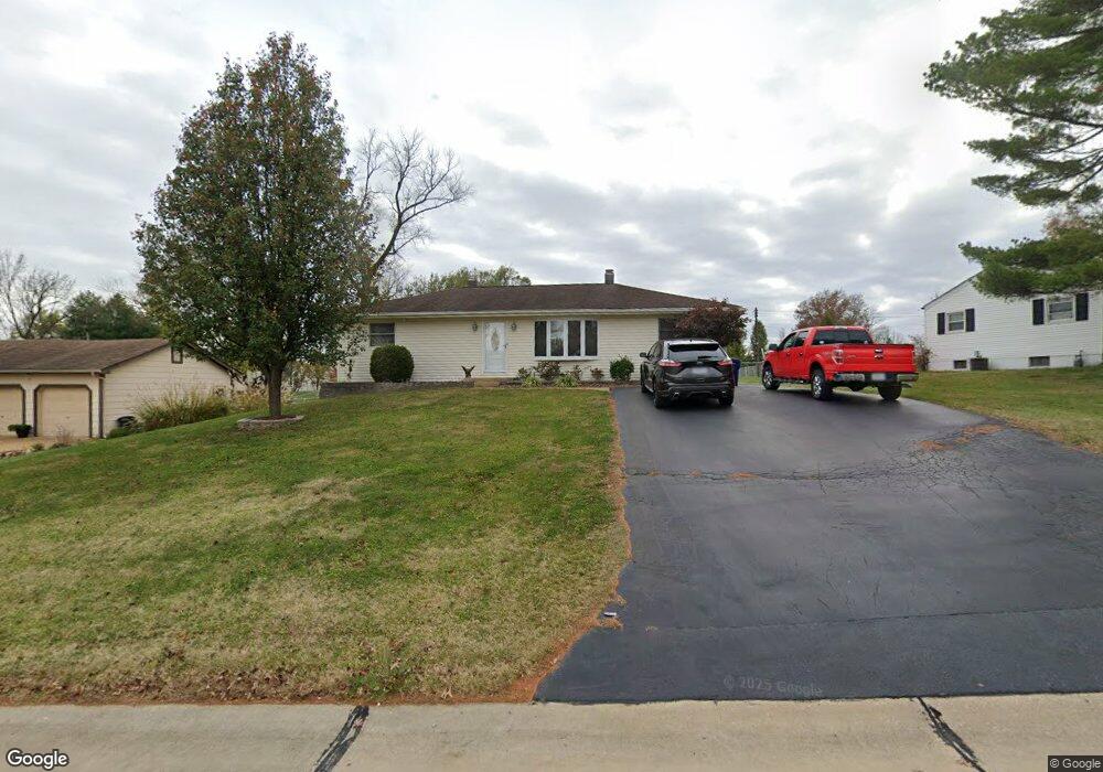
4236 Ringford Dr Saint Louis, MO 63129
Mehlville NeighborhoodEstimated Value: $251,632 - $291,000
2
Beds
1
Bath
1,312
Sq Ft
$204/Sq Ft
Est. Value
About This Home
This home is located at 4236 Ringford Dr, Saint Louis, MO 63129 and is currently estimated at $267,408, approximately $203 per square foot. 4236 Ringford Dr is a home located in St. Louis County with nearby schools including Oakville Elementary School, Bernard Middle School, and Oakville Senior High School.
Ownership History
Date
Name
Owned For
Owner Type
Purchase Details
Closed on
Aug 21, 2006
Sold by
Hessler John P and Hessler Nancy
Bought by
Espey Gregg and Espey Deborah
Current Estimated Value
Home Financials for this Owner
Home Financials are based on the most recent Mortgage that was taken out on this home.
Original Mortgage
$185,000
Outstanding Balance
$111,131
Interest Rate
6.77%
Mortgage Type
New Conventional
Estimated Equity
$156,277
Create a Home Valuation Report for This Property
The Home Valuation Report is an in-depth analysis detailing your home's value as well as a comparison with similar homes in the area
Home Values in the Area
Average Home Value in this Area
Purchase History
| Date | Buyer | Sale Price | Title Company |
|---|---|---|---|
| Espey Gregg | $185,000 | Sec |
Source: Public Records
Mortgage History
| Date | Status | Borrower | Loan Amount |
|---|---|---|---|
| Open | Espey Gregg | $185,000 |
Source: Public Records
Tax History Compared to Growth
Tax History
| Year | Tax Paid | Tax Assessment Tax Assessment Total Assessment is a certain percentage of the fair market value that is determined by local assessors to be the total taxable value of land and additions on the property. | Land | Improvement |
|---|---|---|---|---|
| 2025 | $2,563 | $46,490 | $29,240 | $17,250 |
| 2024 | $2,563 | $38,020 | $12,540 | $25,480 |
| 2023 | $2,563 | $38,020 | $12,540 | $25,480 |
| 2022 | $2,562 | $38,710 | $13,590 | $25,120 |
| 2021 | $2,480 | $38,710 | $13,590 | $25,120 |
| 2020 | $2,125 | $31,500 | $11,170 | $20,330 |
| 2019 | $2,119 | $31,500 | $11,170 | $20,330 |
| 2018 | $2,032 | $27,260 | $10,050 | $17,210 |
| 2017 | $2,029 | $27,260 | $10,050 | $17,210 |
| 2016 | $1,605 | $20,610 | $7,200 | $13,410 |
| 2015 | $1,475 | $20,610 | $7,200 | $13,410 |
| 2014 | $1,810 | $25,140 | $4,830 | $20,310 |
Source: Public Records
Map
Nearby Homes
- 4101 Forder Circle Dr
- 643 Tanya Court Dr
- 4061 Morningview Ct
- 525 Fairwick Dr
- 4301 Heinle Dr
- 2838 Flintwood Dr
- 4376 Tavistock Cir Unit 18D
- 35 Berview Cir Unit E
- 9 Berview Cir Unit H
- 4363 Tavistock Cir Unit 22C
- 1 Berview Cir Unit B
- 4248 Kingbolt Blvd Unit D
- 5046 Lomar Ln
- 1057 Mersey Bend Dr Unit C
- 4812 Idecker Ridge
- 1076 Humber Cir
- 5126 Firelight Ct
- 4923 Southridge Park Dr
- 517 Aqua Ridge Dr
- 1084 Mersey Bend Dr Unit F
- 4244 Ringford Dr
- 4228 Ringford Dr
- 4220 Ringford Dr
- 4252 Ringford Dr
- 4334 Ringer Rd
- 777 Forder Manor Dr
- 781 Forder Manor Dr
- 4340 Ringer Rd
- 785 Forder Manor Dr
- 773 Forder Manor Dr
- 789 Forder Manor Dr
- 4237 Ringford Dr
- 4245 Ringford Dr
- 769 Forder Manor Dr
- 769 Forder Manor Dr Unit END
- 4253 Ringford Dr
- 793 Forder Manor Dr
- 4212 Ringford Dr
- 4259 Ringford Dr
- 4229 Ringford Dr