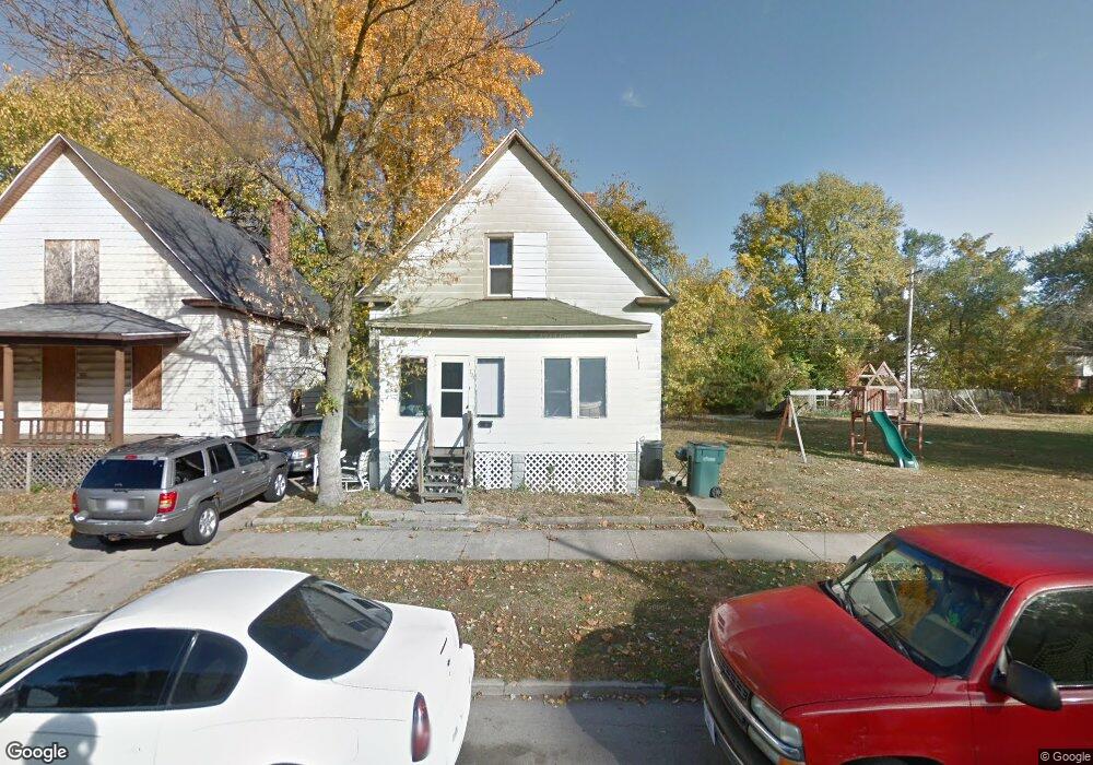
424 E Waggoner St Decatur, IL 62526
Martin Luther King NeighborhoodEstimated Value: $32,000 - $55,000
Studio
--
Bath
846
Sq Ft
$49/Sq Ft
Est. Value
About This Home
This home is located at 424 E Waggoner St, Decatur, IL 62526 and is currently estimated at $41,090, approximately $48 per square foot. 424 E Waggoner St is a home located in Macon County with nearby schools including Hope Academy.
Ownership History
Date
Name
Owned For
Owner Type
Purchase Details
Closed on
Jun 23, 2023
Sold by
Rawls Jerry C
Bought by
Transformation Life Changers Cares 4 You
Current Estimated Value
Purchase Details
Closed on
Jul 2, 2020
Sold by
Cole Wilbert
Bought by
Rawls Jerry C
Purchase Details
Closed on
Mar 3, 2020
Sold by
Rawls Ella
Bought by
Rawls Jerry
Purchase Details
Closed on
Mar 27, 2017
Sold by
S & J Impact Investments Ii Llc
Bought by
Rawls Jerry C
Purchase Details
Closed on
Mar 31, 2015
Sold by
Gortler Rafael
Bought by
S And J Impact Investments Ii Llc
Purchase Details
Closed on
Aug 1, 2010
Create a Home Valuation Report for This Property
The Home Valuation Report is an in-depth analysis detailing your home's value as well as a comparison with similar homes in the area
Home Values in the Area
Average Home Value in this Area
Purchase History
| Date | Buyer | Sale Price | Title Company |
|---|---|---|---|
| Transformation Life Changers Cares 4 You | -- | None Listed On Document | |
| Rawls Jerry C | -- | None Available | |
| Rawls Jerry | -- | None Available | |
| Rawls Jerry C | -- | None Available | |
| S And J Impact Investments Ii Llc | -- | None Available | |
| -- | -- | -- |
Source: Public Records
Tax History
| Year | Tax Paid | Tax Assessment Tax Assessment Total Assessment is a certain percentage of the fair market value that is determined by local assessors to be the total taxable value of land and additions on the property. | Land | Improvement |
|---|---|---|---|---|
| 2024 | $435 | $4,495 | $436 | $4,059 |
| 2023 | -- | $4,336 | $421 | $3,915 |
| 2022 | $0 | $4,124 | $389 | $3,735 |
| 2021 | $0 | $3,852 | $364 | $3,488 |
| 2020 | $0 | $3,674 | $348 | $3,326 |
| 2019 | $0 | $3,674 | $348 | $3,326 |
| 2018 | $365 | $3,872 | $164 | $3,708 |
| 2017 | $416 | $3,975 | $168 | $3,807 |
| 2016 | $424 | $4,016 | $170 | $3,846 |
| 2015 | $403 | $3,945 | $167 | $3,778 |
| 2014 | $377 | $3,906 | $165 | $3,741 |
| 2013 | $387 | $4,052 | $171 | $3,881 |
Source: Public Records
Map
Nearby Homes
- 1590 N Water St
- 1568 N Main St
- 240 E Olive St
- 1595 N Church St
- 254 W Leafland Ave
- 1237 N Calhoun St
- 1521 N Union St
- 5 East Dr
- 1135 E Locust St
- 1914 N Union St
- 216 W Garfield Ave
- 1166 E Walnut St
- 2051 N Church St
- 2005 N Union St
- 377 Burtschi Ct
- 1045 N Monroe St
- 1437 E Division St
- 2428 N Dunn Dr Unit DU2428
- 1653 N Maple Ave
- 1659 N Maple Ave
- 416 E Waggoner St
- 1424 N Warren St
- 439 E Center St
- 450 E Waggoner St
- 405 E Waggoner St
- 429 E Waggoner St
- 433 E Waggoner St
- 453 E Center St
- 415 E Center St
- 437 E Waggoner St
- 1340 N Warren St
- 509 E Center St
- 404 E Center St
- 515 E Center St
- 428 E Grand Ave
- 410 E Center St
- 1306 N Warren St
- 523 E Center St
- 523 E Waggoner St
- 394 E Center St
Your Personal Tour Guide
Ask me questions while you tour the home.