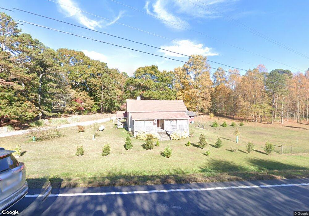
4241 Duncan Bridge Rd SW Cornelia, GA 30531
Estimated Value: $273,000 - $367,000
2
Beds
1
Bath
1,872
Sq Ft
$159/Sq Ft
Est. Value
About This Home
This home is located at 4241 Duncan Bridge Rd SW, Cornelia, GA 30531 and is currently estimated at $298,371, approximately $159 per square foot. 4241 Duncan Bridge Rd SW is a home located in Habersham County with nearby schools including Level Grove Elementary School, South Habersham Middle School, and Habersham Success Academy.
Ownership History
Date
Name
Owned For
Owner Type
Purchase Details
Closed on
Sep 21, 2018
Sold by
Cochran Samuel M
Bought by
Cochran Claudia June
Current Estimated Value
Purchase Details
Closed on
May 26, 2017
Sold by
Smith Hugh B
Bought by
Cochran Samuel M and Cochran Claudia June
Purchase Details
Closed on
Apr 3, 2009
Sold by
Smith Hugh B
Bought by
Smith Hugh B
Create a Home Valuation Report for This Property
The Home Valuation Report is an in-depth analysis detailing your home's value as well as a comparison with similar homes in the area
Home Values in the Area
Average Home Value in this Area
Purchase History
| Date | Buyer | Sale Price | Title Company |
|---|---|---|---|
| Cochran Claudia June | -- | -- | |
| Cochran Samuel M | $55,000 | -- | |
| Smith Hugh B | -- | -- |
Source: Public Records
Tax History Compared to Growth
Tax History
| Year | Tax Paid | Tax Assessment Tax Assessment Total Assessment is a certain percentage of the fair market value that is determined by local assessors to be the total taxable value of land and additions on the property. | Land | Improvement |
|---|---|---|---|---|
| 2025 | $380 | $93,960 | $27,388 | $66,572 |
| 2024 | -- | $62,312 | $22,148 | $40,164 |
| 2023 | $145 | $55,700 | $22,148 | $33,552 |
| 2022 | $355 | $42,356 | $13,288 | $29,068 |
| 2021 | $331 | $37,100 | $11,076 | $26,024 |
| 2020 | $330 | $33,656 | $11,076 | $22,580 |
| 2019 | $906 | $33,656 | $11,076 | $22,580 |
| 2018 | $588 | $22,000 | $9,020 | $12,980 |
| 2017 | $675 | $25,148 | $11,076 | $14,072 |
| 2016 | $664 | $63,710 | $11,076 | $14,408 |
| 2015 | $657 | $63,710 | $11,076 | $14,408 |
| 2014 | $676 | $64,360 | $11,076 | $14,668 |
| 2013 | -- | $25,744 | $11,076 | $14,668 |
Source: Public Records
Map
Nearby Homes
- 4880 Pea Ridge Rd
- 450 Beachwood Dr
- 434 Beachwood Dr
- 335 Laurel Place Dr
- 240 Woodmont Dr
- 0 Casa Rio Dr Unit 24246964
- 0 Casa Rio Dr Unit 10576144
- 255 Laurel Place Dr
- 440 River Bridge Loop
- 301 Kissimmee Trail
- 214 Homer Stephens Rd
- 0 Hellyer Dr Unit 10656263
- 212 Fernbank Dr
- 1.73 ACRES TR3 Garrison Rd
- 1.18 ACRES Garrison Rd
- 1.70 ACRES Garrison Rd
- 2.16 ACRES Garrison Rd
- 1307 Creasy Patch Rd
- 329 Twisting Ridge Trail
- 10454 Duncan Bridge Rd
- 4238 Duncan Bridge Rd
- 4237 Duncan Bridge Rd
- 4214 Duncan Bridge Rd
- 4241 Duncan Bridge Rd
- 4283 Duncan Bridge Rd
- 4137 Duncan Bridge Rd
- 4245 Duncan Bridge Rd
- 4245 Duncan Bridge Rd
- 4289 Duncan Bridge Rd
- 4285 Duncan Bridge Rd
- 4066 Duncan Bridge Rd
- 4411 Duncan Bridge Rd
- 4210 Pea Ridge Rd
- 372 Collinwood Ln
- 370 Collinwood Ln
- 269 Wood St
- 4160 Pea Ridge Rd
- 4046 Pea Ridge Rd
- 358 Collinwood Ln
- 4200 Pea Ridge Rd