Estimated Value: $273,347 - $393,000
3
Beds
3
Baths
1,680
Sq Ft
$197/Sq Ft
Est. Value
About This Home
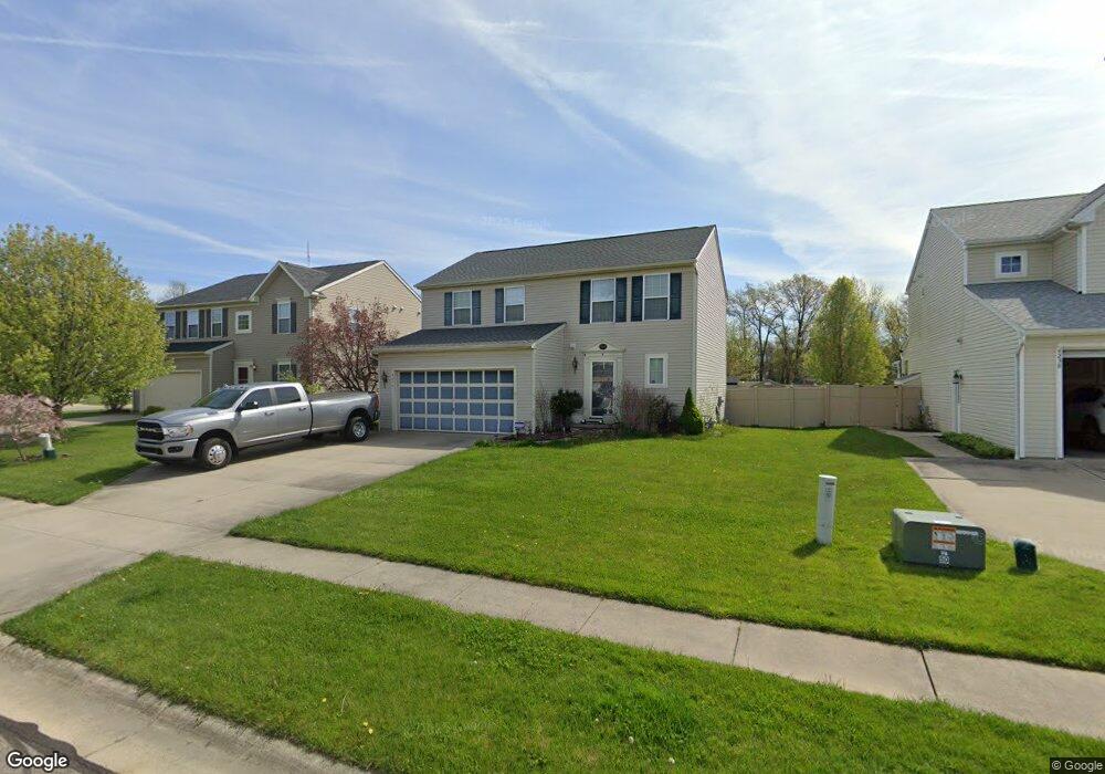
This home is located at 4244 Whitestone Rd, Kent, OH 44240 and is currently estimated at $331,087, approximately $197 per square foot. 4244 Whitestone Rd is a home located in Portage County with nearby schools including Brimfield Elementary School, Field Middle School, and Field High School.
Ownership History
Date
Name
Owned For
Owner Type
Purchase Details
Closed on
Feb 6, 2009
Sold by
Nvr Inc
Bought by
Johnson Sheila A
Current Estimated Value
Home Financials for this Owner
Home Financials are based on the most recent Mortgage that was taken out on this home.
Original Mortgage
$137,744
Interest Rate
5.11%
Mortgage Type
Purchase Money Mortgage
Purchase Details
Closed on
Sep 4, 2008
Sold by
Lemmon & Lemmon Inc
Bought by
Nvr Inc and Ryan Homes
Purchase Details
Closed on
Feb 23, 2006
Sold by
Casamento Michael R and Flynn John J
Bought by
Lemmon & Lemmon Inc
Create a Home Valuation Report for This Property
The Home Valuation Report is an in-depth analysis detailing your home's value as well as a comparison with similar homes in the area
Home Values in the Area
Average Home Value in this Area
Purchase History
| Date | Buyer | Sale Price | Title Company |
|---|---|---|---|
| Johnson Sheila A | $139,200 | Nvr Title Agency Llc | |
| Nvr Inc | $32,000 | Nvr Title Agency Llc | |
| Lemmon & Lemmon Inc | -- | None Available |
Source: Public Records
Mortgage History
| Date | Status | Borrower | Loan Amount |
|---|---|---|---|
| Previous Owner | Johnson Sheila A | $137,744 |
Source: Public Records
Tax History
| Year | Tax Paid | Tax Assessment Tax Assessment Total Assessment is a certain percentage of the fair market value that is determined by local assessors to be the total taxable value of land and additions on the property. | Land | Improvement |
|---|---|---|---|---|
| 2024 | $3,620 | $85,230 | $12,250 | $72,980 |
| 2023 | $3,490 | $67,690 | $12,250 | $55,440 |
| 2022 | $3,524 | $67,690 | $12,250 | $55,440 |
| 2021 | $3,435 | $67,690 | $12,250 | $55,440 |
| 2020 | $3,258 | $59,220 | $12,250 | $46,970 |
| 2019 | $3,215 | $59,220 | $12,250 | $46,970 |
| 2017 | $2,375 | $53,200 | $12,250 | $40,950 |
| 2016 | $2,368 | $53,200 | $12,250 | $40,950 |
Source: Public Records
Map
Nearby Homes
- 4360 Beal Dr
- 4545 State Route 43
- 4088 Lynwood Dr
- 3793 Ranfield Rd
- 1386 Brookdale Ln
- 4808 Sherman Rd
- 3880 Selnik Rd
- 3910 Willow Way
- 3929 Lor Ron St
- 1676 Countryview Dr
- 3555 Jameson Dr
- 3532 Gary Dr
- 3517 Jameson Dr
- 788 Cambridge Ct
- 3483 Lawndale Dr
- 4595 Creekside Dr
- 5088 Spruce Knoll Run
- 2092 Sugar Maple Dr
- 0 Meloy Rd Unit 5162435
- 1233 Cedar Ridge Rd
- 4238 Whitestone Rd
- 4250 Whitestone Rd
- 4248 Pembroke Dr
- 1467 Parsons Dr
- 4243 Whitestone Rd
- 4237 Whitestone Rd
- 4224 Whitestone Rd
- 1476 Parsons Dr
- 4242 Pembroke Dr
- 4249 Whitestone Rd
- 4229 Whitestone Rd
- 4255 Whitestone Rd
- 1457 Parsons Dr
- 1465 Parsons Dr
- 1451 Parsons Dr
- 4216 Whitestone Rd
- 4236 Pembroke Dr
- 4239 Pembroke Dr
- 4223 Whitestone Rd
- 1471 Parsons Dr
Your Personal Tour Guide
Ask me questions while you tour the home.