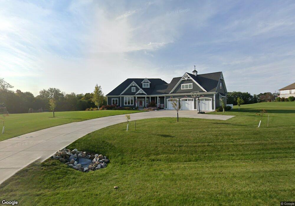
4247 S Woodcrest Ridge Dr West Bend, WI 53095
Estimated Value: $671,673 - $1,071,000
--
Bed
--
Bath
--
Sq Ft
3
Acres
About This Home
This home is located at 4247 S Woodcrest Ridge Dr, West Bend, WI 53095 and is currently estimated at $855,668. 4247 S Woodcrest Ridge Dr is a home located in Washington County with nearby schools including McLane Elementary School, Silverbrook Intermediate School, and East High School.
Ownership History
Date
Name
Owned For
Owner Type
Purchase Details
Closed on
Jun 18, 2024
Sold by
Melzark Dustin R and Melzark Jennifer C
Bought by
Dustin And Jennifer Melzark Revocable Tr
Current Estimated Value
Purchase Details
Closed on
May 10, 2018
Sold by
Theusch Kim
Bought by
Melzark Dustin R and Melzark Jennifer C
Home Financials for this Owner
Home Financials are based on the most recent Mortgage that was taken out on this home.
Original Mortgage
$61,520
Interest Rate
3.5%
Mortgage Type
Adjustable Rate Mortgage/ARM
Purchase Details
Closed on
Jul 17, 2009
Sold by
Theusch Mary Anne
Bought by
Theusch Kim and Mary Anne Theusch Surviors Trust
Purchase Details
Closed on
Mar 29, 2007
Sold by
Castle Development Ii
Bought by
Theusch Terry J and Theusch Mary Anne
Create a Home Valuation Report for This Property
The Home Valuation Report is an in-depth analysis detailing your home's value as well as a comparison with similar homes in the area
Home Values in the Area
Average Home Value in this Area
Purchase History
| Date | Buyer | Sale Price | Title Company |
|---|---|---|---|
| Dustin And Jennifer Melzark Revocable Tr | -- | -- | |
| Melzark Dustin R | $76,900 | None Available | |
| Theusch Kim | -- | None Available | |
| Theusch Terry J | $147,000 | None Available |
Source: Public Records
Mortgage History
| Date | Status | Borrower | Loan Amount |
|---|---|---|---|
| Previous Owner | Melzark Dustin R | $61,520 |
Source: Public Records
Tax History Compared to Growth
Tax History
| Year | Tax Paid | Tax Assessment Tax Assessment Total Assessment is a certain percentage of the fair market value that is determined by local assessors to be the total taxable value of land and additions on the property. | Land | Improvement |
|---|---|---|---|---|
| 2024 | $5,425 | $675,500 | $98,900 | $576,600 |
| 2023 | $4,649 | $373,400 | $70,700 | $302,700 |
| 2022 | $4,649 | $373,400 | $70,700 | $302,700 |
| 2021 | $4,847 | $356,800 | $70,700 | $286,100 |
| 2020 | $4,507 | $349,500 | $70,700 | $278,800 |
| 2019 | $2,854 | $240,700 | $70,700 | $170,000 |
| 2018 | $509 | $43,000 | $43,000 | $0 |
| 2017 | $508 | $43,000 | $43,000 | $0 |
| 2016 | $518 | $43,000 | $43,000 | $0 |
| 2015 | -- | $43,000 | $43,000 | $0 |
| 2014 | -- | $43,000 | $43,000 | $0 |
| 2013 | $550 | $43,000 | $43,000 | $0 |
Source: Public Records
Map
Nearby Homes
- 4262 N Woodcrest Ridge Dr
- 6215 Riesch Rd
- 4538 Church Dr
- 6043 State Highway 144
- 3316 Mediterranean Ave
- 3315 Windsor Place
- 2820 Valley Ave
- 6837 Reuter Ln
- 5880 Scenic Dr
- Lt3-5 Schuster Dr
- Lt3 Schuster Dr
- Lt5 Schuster Dr
- Lt4 Schuster Dr
- 805 Canterberry Ct Unit C
- 2346 W Washington St
- 2606 Park Forest Dr
- 4000 W Washington St
- 2106 Chestnut St
- 2124 Willowbrook Dr
- 1925 Hilltop Dr
- 4268 S Woodcrest Ridge Dr
- 4257 S Woodcrest Ridge Dr
- 4288 S Woodcrest Ridge Dr
- 4237 S Woodcrest Ridge Dr
- 4207 S Woodcrest Ridge Dr
- 4232 S Woodcrest Ridge Dr
- 4261 S Woodcrest Ridge Dr
- 4177 S Woodcrest Ridge Dr
- 4177 S Woodcrest Ridge Dr Unit Lt16
- 4279 S Woodcrest Ridge Dr
- 4190 S Woodcrest Ridge Dr
- 4263 S Woodcrest Ridge Dr
- 4275 S Woodcrest Ridge Dr
- 4283 S Woodcrest Ridge Dr
- 4273 S Woodcrest Ridge Dr
- 4281 S Woodcrest Ridge Dr
- 4147 S Woodcrest Ridge Dr
- 4147 S Woodcrest Ridge Dr
- 4271 S Woodcrest Ridge Dr
- 6290 Riesch Rd