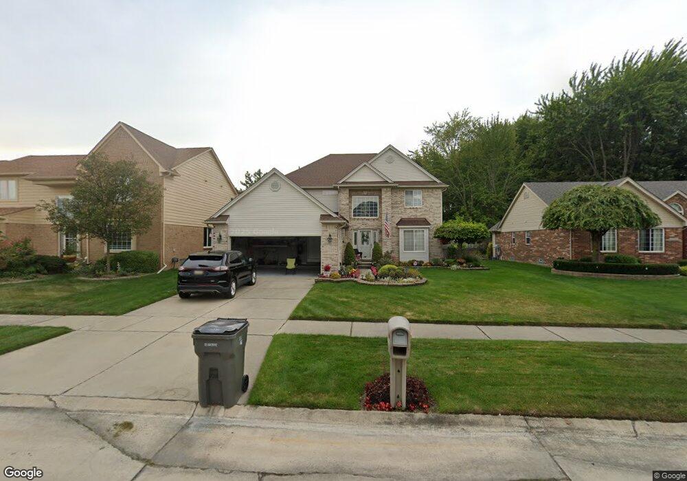
42471 Sheridan Dr Clinton Township, MI 48038
Estimated Value: $426,184 - $472,000
4
Beds
3
Baths
2,424
Sq Ft
$187/Sq Ft
Est. Value
About This Home
This home is located at 42471 Sheridan Dr, Clinton Township, MI 48038 and is currently estimated at $453,796, approximately $187 per square foot. 42471 Sheridan Dr is a home located in Macomb County with nearby schools including Erie Elementary School, Wyandot Middle School, and Chippewa Valley High School.
Ownership History
Date
Name
Owned For
Owner Type
Purchase Details
Closed on
Apr 20, 2000
Sold by
Lindeman Todd D
Bought by
Patrosso Robert W
Current Estimated Value
Home Financials for this Owner
Home Financials are based on the most recent Mortgage that was taken out on this home.
Original Mortgage
$56,900
Outstanding Balance
$19,353
Interest Rate
8.13%
Estimated Equity
$434,443
Purchase Details
Closed on
Apr 1, 1998
Sold by
Seville Homes
Bought by
Lindeman T T
Create a Home Valuation Report for This Property
The Home Valuation Report is an in-depth analysis detailing your home's value as well as a comparison with similar homes in the area
Home Values in the Area
Average Home Value in this Area
Purchase History
| Date | Buyer | Sale Price | Title Company |
|---|---|---|---|
| Patrosso Robert W | $236,900 | -- | |
| Lindeman T T | $189,000 | -- |
Source: Public Records
Mortgage History
| Date | Status | Borrower | Loan Amount |
|---|---|---|---|
| Open | Patrosso Robert W | $56,900 |
Source: Public Records
Tax History Compared to Growth
Tax History
| Year | Tax Paid | Tax Assessment Tax Assessment Total Assessment is a certain percentage of the fair market value that is determined by local assessors to be the total taxable value of land and additions on the property. | Land | Improvement |
|---|---|---|---|---|
| 2025 | $5,642 | $213,900 | $0 | $0 |
| 2024 | $3,361 | $201,400 | $0 | $0 |
| 2023 | $3,188 | $176,300 | $0 | $0 |
| 2022 | $5,112 | $158,800 | $0 | $0 |
| 2021 | $4,972 | $151,200 | $0 | $0 |
| 2020 | $2,925 | $149,500 | $0 | $0 |
| 2019 | $4,631 | $144,900 | $0 | $0 |
| 2018 | $4,535 | $135,000 | $0 | $0 |
| 2017 | $4,494 | $129,100 | $25,000 | $104,100 |
| 2016 | $4,466 | $129,100 | $0 | $0 |
| 2015 | -- | $121,600 | $0 | $0 |
| 2014 | -- | $114,400 | $0 | $0 |
| 2011 | -- | $103,600 | $20,300 | $83,300 |
Source: Public Records
Map
Nearby Homes
- 42328 Sheridan Ct
- 19790 Westchester Dr Unit 11
- 20784 Cannon Dr
- 0 Clinton River Rd Unit 20251013874
- 42680 Chippewa Dr Unit 28
- 20465 Saint Laurence Dr
- 20947 Riverbend Dr S Unit 87
- 41704 Clinton Pines Dr
- 43378 Riverbend Blvd
- 42243 Little Rd
- 43440 Riverbend Blvd
- 20140 Shoals Ct Unit 16
- 42125 Little Rd
- 20757 Cueter Ln
- 41992 Merrimac Cir
- 20654 Dunham Rd Unit 24
- 20330 Rambling Dr
- 43377 Rivergate Dr
- 20561 Longwood Dr Unit 64
- 42002 Coulon Dr
- 42495 Sheridan Dr
- 42447 Sheridan Dr
- 20725 Gaberty Dr
- 42519 Sheridan Dr
- 20715 Gaberty Dr
- 42472 Sheridan Dr
- 42496 Sheridan Dr
- 42448 Sheridan Dr
- 42543 Sheridan Dr
- 42399 Sheridan Ct
- 42520 Sheridan Dr
- 20705 Gaberty Dr
- 20724 Gaberty Dr
- 42567 Sheridan Dr
- 42544 Sheridan Dr
- 42400 Sheridan Ct
- 20695 Gaberty Dr
- 42475 Dharte Ct
- 42375 Sheridan Ct
- 42499 Dharte Ct