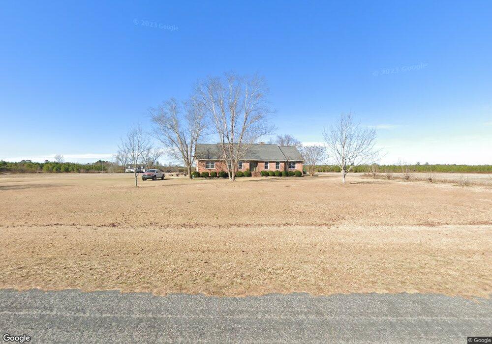
425 Browntown Rd Sumter, SC 29153
Estimated Value: $262,000 - $385,082
4
Beds
4
Baths
2,811
Sq Ft
$115/Sq Ft
Est. Value
About This Home
This home is located at 425 Browntown Rd, Sumter, SC 29153 and is currently estimated at $324,021, approximately $115 per square foot. 425 Browntown Rd is a home located in Sumter County with nearby schools including RE Davis College Preparatory Academy, Mayewood Middle, and Crestwood High School.
Ownership History
Date
Name
Owned For
Owner Type
Purchase Details
Closed on
Mar 30, 2012
Sold by
Brown Melvin E
Bought by
Brown Melvin E and Brown Tamorah L
Current Estimated Value
Home Financials for this Owner
Home Financials are based on the most recent Mortgage that was taken out on this home.
Original Mortgage
$122,977
Interest Rate
3.97%
Mortgage Type
Future Advance Clause Open End Mortgage
Create a Home Valuation Report for This Property
The Home Valuation Report is an in-depth analysis detailing your home's value as well as a comparison with similar homes in the area
Purchase History
| Date | Buyer | Sale Price | Title Company |
|---|---|---|---|
| Brown Melvin E | -- | -- |
Source: Public Records
Mortgage History
| Date | Status | Borrower | Loan Amount |
|---|---|---|---|
| Closed | Brown Melvin E | $122,977 |
Source: Public Records
Tax History
| Year | Tax Paid | Tax Assessment Tax Assessment Total Assessment is a certain percentage of the fair market value that is determined by local assessors to be the total taxable value of land and additions on the property. | Land | Improvement |
|---|---|---|---|---|
| 2025 | $1,167 | $7,290 | $280 | $7,010 |
| 2024 | $1,167 | $7,290 | $280 | $7,010 |
| 2023 | $1,167 | $7,290 | $280 | $7,010 |
| 2022 | $1,165 | $7,290 | $280 | $7,010 |
| 2021 | $505 | $7,290 | $280 | $7,010 |
| 2020 | $1,116 | $6,610 | $280 | $6,330 |
| 2019 | $1,089 | $6,610 | $280 | $6,330 |
| 2018 | $1,022 | $6,610 | $280 | $6,330 |
| 2017 | $1,007 | $6,610 | $280 | $6,330 |
| 2016 | $1,072 | $6,610 | $280 | $6,330 |
| 2015 | $1,056 | $6,470 | $280 | $6,190 |
| 2014 | $1,056 | $6,470 | $280 | $6,190 |
| 2013 | -- | $6,470 | $280 | $6,190 |
Source: Public Records
Map
Nearby Homes
- 4120 Highway 15 N
- 3805 Colony Cir
- 3670 Hwy 15 N
- 60 Olin Goode Dr
- 485 E Emerald Lake Dr
- 3821 Nicole Ln
- 785 Westbury Mill Rd
- 5555 Goshen Rd
- 0 Bell Rd Unit 630477
- 270 Bell Rd
- 4955 Rogdwin Rd
- 2341 Old Whites Mill Rd
- 1830 Wildhorse Dr
- 1843 Wildhorse Dr
- 80 Lillie Dr
- 4025 Sumter Hwy
- 1415 Bell Rd
- 5505 Raymond Jenkins St
- 2249 Citation St Unit 12
- 2249 Citation St
- 600 Munn Brown Rd
- 365 Browntown Rd
- 0 Browntown Rd
- 0 Browntown Rd
- 570 Browntown Rd
- 580 Browntown Rd
- 240 Browntown Rd
- 790 Goodson Rd
- 405 Munn Brown Rd
- 850 Goodson Rd
- 50 Dunk Dr
- 865 Goodson Rd
- 4615 Hwy 15 N
- 4340 Hardaway Ln
- 4500 Highway 15 N
- 4415 Hwy 15 N
- 65 Browntown Rd
- 55 Browntown Rd
- 4710 Highway 15 N
- 4320 Highway 15 N
Your Personal Tour Guide
Ask me questions while you tour the home.