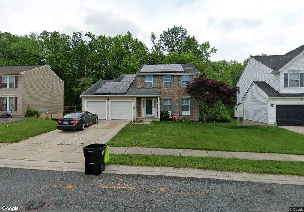
425 Silverside Rd Edgewood, MD 21040
Estimated Value: $390,000 - $400,221
Studio
3
Baths
1,869
Sq Ft
$212/Sq Ft
Est. Value
About This Home
This home is located at 425 Silverside Rd, Edgewood, MD 21040 and is currently estimated at $395,805, approximately $211 per square foot. 425 Silverside Rd is a home located in Harford County with nearby schools including Deerfield Elementary School, Edgewood Middle School, and Edgewood High School.
Ownership History
Date
Name
Owned For
Owner Type
Purchase Details
Closed on
Feb 8, 2005
Sold by
Volinski Vincent Edward
Bought by
Adeosun Olusegun A and Adeosun Oluwakemi A
Current Estimated Value
Home Financials for this Owner
Home Financials are based on the most recent Mortgage that was taken out on this home.
Original Mortgage
$237,500
Outstanding Balance
$116,727
Interest Rate
5.25%
Mortgage Type
Adjustable Rate Mortgage/ARM
Estimated Equity
$279,078
Purchase Details
Closed on
Feb 10, 1999
Sold by
Ortel Michael G
Bought by
Volinski Vincent Edward
Purchase Details
Closed on
Aug 21, 1997
Sold by
Bob Ward Inc
Bought by
Ortel Michael G and Smith Darla M A
Create a Home Valuation Report for This Property
The Home Valuation Report is an in-depth analysis detailing your home's value as well as a comparison with similar homes in the area
Home Values in the Area
Average Home Value in this Area
Purchase History
| Date | Buyer | Sale Price | Title Company |
|---|---|---|---|
| Adeosun Olusegun A | $250,000 | -- | |
| Volinski Vincent Edward | $153,000 | -- | |
| Ortel Michael G | $152,875 | -- |
Source: Public Records
Mortgage History
| Date | Status | Borrower | Loan Amount |
|---|---|---|---|
| Open | Adeosun Olusegun A | $237,500 | |
| Closed | Ortel Michael G | -- |
Source: Public Records
Tax History
| Year | Tax Paid | Tax Assessment Tax Assessment Total Assessment is a certain percentage of the fair market value that is determined by local assessors to be the total taxable value of land and additions on the property. | Land | Improvement |
|---|---|---|---|---|
| 2025 | $3,002 | $294,700 | $0 | $0 |
| 2024 | $3,002 | $275,400 | $0 | $0 |
| 2023 | $2,791 | $256,100 | $79,800 | $176,300 |
| 2022 | $2,687 | $246,500 | $0 | $0 |
| 2021 | $2,623 | $236,900 | $0 | $0 |
| 2020 | $2,623 | $227,300 | $79,800 | $147,500 |
| 2019 | $2,612 | $226,367 | $0 | $0 |
| 2018 | $2,578 | $225,433 | $0 | $0 |
| 2017 | $2,567 | $224,500 | $0 | $0 |
| 2016 | $140 | $223,367 | $0 | $0 |
| 2015 | $3,146 | $222,233 | $0 | $0 |
| 2014 | $3,146 | $221,100 | $0 | $0 |
Source: Public Records
Map
Nearby Homes
- 308 Laburnum Rd
- 2961 Siwanoy Dr
- 2970 Siwanoy Dr
- 606 Harbour Oak Dr
- 2935 Ancon Ct
- 3901 Walters Rd
- 3905 Love Ave
- 303 Lord Willoughby Way
- 3913 Love Ct
- 408 Bauers Dr
- 62 Little Creek Ln
- 1071 Sand Pebble Dr
- 904 A W Baker Ave
- 1000 W Viking Ct
- 503 Catalpa Ln
- 1114 E Viking Ct
- 2707 Pulaski Hwy
- 2314 Rosewood Dr
- 3800 & 3804 Pulaski Hwy
- 3805 Longley Rd
- 501 Silverside Rd
- 423 Silverside Rd
- 421 Silverside Rd
- 503 Silverside Rd
- 500 Molly Ct
- 419 Silverside Rd
- 500 Silverside Rd
- 505 Silverside Rd
- 504 Silverside Rd
- 502 Molly Ct
- 417 Silverside Rd
- 507 Silverside Rd
- 501 Arum Ct
- 503 Molly Ct
- 504 Molly Ct
- 415 Silverside Rd
- 508 Silverside Rd
- 509 Silverside Rd
- 503 Arum Ct
- 506 Molly Ct
Your Personal Tour Guide
Ask me questions while you tour the home.