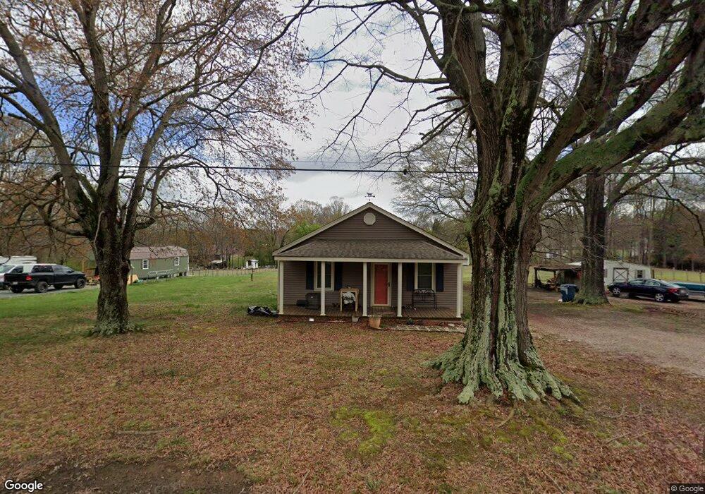
425 Sloop St China Grove, NC 28023
Estimated Value: $175,777 - $199,000
2
Beds
1
Bath
840
Sq Ft
$223/Sq Ft
Est. Value
About This Home
This home is located at 425 Sloop St, China Grove, NC 28023 and is currently estimated at $187,194, approximately $222 per square foot. 425 Sloop St is a home located in Rowan County with nearby schools including Landis Elementary School, Corriher Lipe Middle School, and South Rowan High School.
Ownership History
Date
Name
Owned For
Owner Type
Purchase Details
Closed on
Nov 20, 2020
Sold by
Raffaldt Amy R
Bought by
Raffaldt Amy R
Current Estimated Value
Home Financials for this Owner
Home Financials are based on the most recent Mortgage that was taken out on this home.
Original Mortgage
$20,000
Outstanding Balance
$17,727
Interest Rate
2.71%
Mortgage Type
New Conventional
Estimated Equity
$169,467
Purchase Details
Closed on
Mar 9, 1992
Bought by
Raffaldt Roy L
Create a Home Valuation Report for This Property
The Home Valuation Report is an in-depth analysis detailing your home's value as well as a comparison with similar homes in the area
Home Values in the Area
Average Home Value in this Area
Purchase History
| Date | Buyer | Sale Price | Title Company |
|---|---|---|---|
| Raffaldt Amy R | -- | None Available | |
| Raffaldt Roy L | $21,500 | -- |
Source: Public Records
Mortgage History
| Date | Status | Borrower | Loan Amount |
|---|---|---|---|
| Open | Raffaldt Amy R | $20,000 | |
| Open | Raffaldt Amy R | $46,000 |
Source: Public Records
Tax History
| Year | Tax Paid | Tax Assessment Tax Assessment Total Assessment is a certain percentage of the fair market value that is determined by local assessors to be the total taxable value of land and additions on the property. | Land | Improvement |
|---|---|---|---|---|
| 2025 | $606 | $89,441 | $29,172 | $60,269 |
| 2024 | $606 | $89,441 | $29,172 | $60,269 |
| 2023 | $606 | $89,441 | $29,172 | $60,269 |
| 2022 | $479 | $63,487 | $24,310 | $39,177 |
| 2021 | $467 | $63,487 | $24,310 | $39,177 |
| 2020 | $467 | $63,487 | $24,310 | $39,177 |
| 2019 | $467 | $63,487 | $24,310 | $39,177 |
| 2018 | $421 | $57,724 | $24,310 | $33,414 |
| 2017 | $421 | $57,724 | $24,310 | $33,414 |
| 2016 | $422 | $57,724 | $24,310 | $33,414 |
| 2015 | $431 | $57,724 | $24,310 | $33,414 |
| 2014 | $432 | $59,075 | $24,310 | $34,765 |
Source: Public Records
Map
Nearby Homes
- 440 Woodland Dr
- 1330 Flat Rock Rd
- 240 Homer Corriher Rd
- 340 Homer Corriher Rd
- 1340 Partee Ln
- 1000 Flat Rock Rd
- 1075 Holland Oaks Dr
- 614 W Ridge Ave
- 0 Overcash Meadow Ln
- 514 W Blume St
- 304 S Kimmons St
- 507 W Blume St
- 406 W Mill St
- 401 W Hoke St
- 2470 Nc 152 W
- 4085 Nc 152 W
- 2005 Nc 152 W
- 202 E Rice St
- 411 S Central Ave
- 0 N Chapel St
- 460 Sloop St
- Lot 1 Sloop St
- 475 Sloop St
- 470 Sloop St
- 355 Sloop St
- 350 Sloop St
- 540 Sloop St
- 515 Sloop St
- 330 Sloop St
- 480 Sheppard Plant Rd
- 270 Sloop St
- 430 Sheppard Plant Rd
- 215 Sloop St
- 575 Sloop St
- 390 Sheppard Plant Rd
- 230 Sloop St
- 530 Sheppard Plant Rd
- 435 Sheppard Plant Rd
- 195 Sloop St
- 625 Sloop St
Your Personal Tour Guide
Ask me questions while you tour the home.