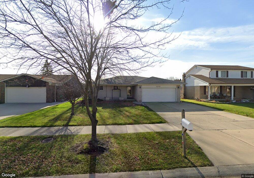
4252 Connie Dr Unit Bldg-Unit Sterling Heights, MI 48310
Estimated Value: $292,000 - $338,000
3
Beds
2
Baths
1,526
Sq Ft
$208/Sq Ft
Est. Value
About This Home
This home is located at 4252 Connie Dr Unit Bldg-Unit, Sterling Heights, MI 48310 and is currently estimated at $317,057, approximately $207 per square foot. 4252 Connie Dr Unit Bldg-Unit is a home located in Macomb County with nearby schools including Jefferson Elementary School, Grissom Middle School, and Sterling Heights Senior H.S..
Ownership History
Date
Name
Owned For
Owner Type
Purchase Details
Closed on
Jul 17, 2020
Sold by
Yousif Rami and Kirma Rami A
Bought by
Integrity Property Investments Llc
Current Estimated Value
Purchase Details
Closed on
Jan 18, 2018
Sold by
Rozel Inc
Bought by
Yousif Rami
Purchase Details
Closed on
Oct 25, 2012
Sold by
Federal National Mortgage Association and Fannie Mae
Bought by
Yousif Rami
Purchase Details
Closed on
Sep 8, 2011
Sold by
Wells Fargo Bank Na
Bought by
Fannie Mae and Federal National Mortgage Association
Purchase Details
Closed on
Aug 11, 2011
Sold by
Fazio Linda S and Fazio James F
Bought by
Wells Fargo Bank Na
Create a Home Valuation Report for This Property
The Home Valuation Report is an in-depth analysis detailing your home's value as well as a comparison with similar homes in the area
Home Values in the Area
Average Home Value in this Area
Purchase History
| Date | Buyer | Sale Price | Title Company |
|---|---|---|---|
| Integrity Property Investments Llc | -- | None Available | |
| Yousif Rami | -- | None Available | |
| Yousif Rami | $98,000 | -- | |
| Fannie Mae | -- | None Available | |
| Wells Fargo Bank Na | $118,116 | None Available |
Source: Public Records
Tax History Compared to Growth
Tax History
| Year | Tax Paid | Tax Assessment Tax Assessment Total Assessment is a certain percentage of the fair market value that is determined by local assessors to be the total taxable value of land and additions on the property. | Land | Improvement |
|---|---|---|---|---|
| 2025 | $6,439 | $147,300 | $0 | $0 |
| 2024 | $6,214 | $138,200 | $0 | $0 |
| 2023 | $5,897 | $124,800 | $0 | $0 |
| 2022 | $5,770 | $111,700 | $0 | $0 |
| 2021 | $5,651 | $105,800 | $0 | $0 |
| 2020 | $5,399 | $99,900 | $0 | $0 |
| 2019 | $5,999 | $94,500 | $0 | $0 |
| 2018 | $3,903 | $89,400 | $0 | $0 |
| 2017 | $3,738 | $83,400 | $13,500 | $69,900 |
| 2016 | $3,654 | $83,400 | $0 | $0 |
| 2015 | -- | $76,500 | $0 | $0 |
| 2014 | -- | $64,300 | $0 | $0 |
Source: Public Records
Map
Nearby Homes
- 4325 Fox Hill Dr
- 3601 Denson Dr
- 38338 Coronation Dr
- 4653 Lucerne Dr
- 4761 Fox Hill Dr
- 37258 Carpathia Blvd
- 4622 Ardmore Dr
- 38576 Cottonwood Dr
- 4732 Ardmore Dr
- 3217 Barton Dr
- 36775 Chene Dr
- 3349 Dobbin Dr
- 37288 Vernon Dr
- 3816 Pokley Ct
- 36687 La Marra Dr
- 37228 Vernon Dr
- 37129 Almont Dr W
- 37207 Almont Dr E
- 38638 Harrison Dr
- 37159 Almont Dr E