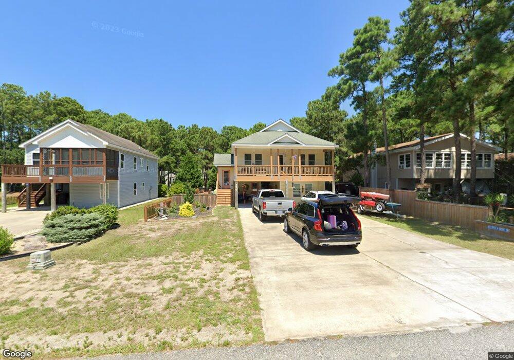
426 Burns Dr Unit 25 Kill Devil Hills, NC 27948
Estimated Value: $524,279 - $606,000
3
Beds
2
Baths
1,430
Sq Ft
$399/Sq Ft
Est. Value
About This Home
This home is located at 426 Burns Dr Unit 25, Kill Devil Hills, NC 27948 and is currently estimated at $571,070, approximately $399 per square foot. 426 Burns Dr Unit 25 is a home located in Dare County with nearby schools including Nags Head Elementary School, Manteo Middle School, and Manteo High School.
Ownership History
Date
Name
Owned For
Owner Type
Purchase Details
Closed on
Feb 15, 2021
Sold by
Pratt Fred L and Pratt Dawn M
Bought by
Turner David Ford and Turner Diane Parker
Current Estimated Value
Home Financials for this Owner
Home Financials are based on the most recent Mortgage that was taken out on this home.
Original Mortgage
$360,000
Outstanding Balance
$320,961
Interest Rate
2.65%
Mortgage Type
New Conventional
Estimated Equity
$250,109
Purchase Details
Closed on
Aug 30, 2010
Sold by
Young Richard J and Young Patricia P
Bought by
Pratt Fred L and Pratt Dawn M
Home Financials for this Owner
Home Financials are based on the most recent Mortgage that was taken out on this home.
Original Mortgage
$184,000
Interest Rate
4.61%
Mortgage Type
New Conventional
Purchase Details
Closed on
Aug 18, 2009
Sold by
Shields David
Bought by
Young Richard J and Young Patricia P
Create a Home Valuation Report for This Property
The Home Valuation Report is an in-depth analysis detailing your home's value as well as a comparison with similar homes in the area
Home Values in the Area
Average Home Value in this Area
Purchase History
| Date | Buyer | Sale Price | Title Company |
|---|---|---|---|
| Turner David Ford | $400,000 | None Available | |
| Pratt Fred L | $230,000 | None Available | |
| Young Richard J | $65,000 | None Available |
Source: Public Records
Mortgage History
| Date | Status | Borrower | Loan Amount |
|---|---|---|---|
| Open | Turner David Ford | $360,000 | |
| Previous Owner | Pratt Fred L | $184,000 |
Source: Public Records
Tax History
| Year | Tax Paid | Tax Assessment Tax Assessment Total Assessment is a certain percentage of the fair market value that is determined by local assessors to be the total taxable value of land and additions on the property. | Land | Improvement |
|---|---|---|---|---|
| 2025 | $2,844 | $522,900 | $157,500 | $365,400 |
| 2024 | $2,267 | $299,300 | $87,500 | $211,800 |
| 2023 | $2,267 | $300,076 | $87,500 | $212,576 |
| 2022 | $2,162 | $300,100 | $87,500 | $212,600 |
| 2021 | $2,133 | $296,000 | $87,500 | $208,500 |
| 2020 | $2,133 | $296,000 | $87,500 | $208,500 |
| 2019 | $1,856 | $213,300 | $60,600 | $152,700 |
| 2018 | $1,815 | $213,300 | $60,600 | $152,700 |
| 2017 | $1,815 | $213,300 | $60,600 | $152,700 |
| 2016 | $1,730 | $213,300 | $60,600 | $152,700 |
| 2014 | $1,666 | $213,300 | $60,600 | $152,700 |
Source: Public Records
Map
Nearby Homes
- 311 Gunas Dr Unit 17
- 311 Gunas Dr
- 1308 Theodore St Unit 5
- 1306 Theodore St Unit Lot 4
- 1208 Swan St Unit 4
- 1208 Swan St Unit 2
- 1208 Swan St Unit 5
- 1208 Swan St Unit 1
- 1208 -2 Swan St Unit 2
- 1208 -1 Swan St Unit 1
- 209 E Lake Dr Unit Lot18
- 205 W Atlantic St Unit Lot 3
- 0 W Martin St
- 111 Carolyn Dr Unit E
- 0 10th Ave Unit Lot 2R 130569
- 2010 S Virginia Dare Trail Unit 104
- 209 E Fresh Pond Dr Unit Lot 10
- 2009 Wrightsville Blvd Unit 1-B
- 2009 Wrightsville Blvd Unit 3A
- 2009 Wrightsville Blvd Unit 4-B
Your Personal Tour Guide
Ask me questions while you tour the home.