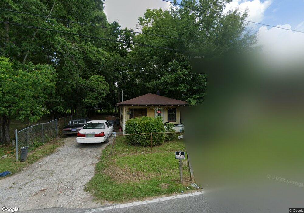
426 Grant Ave Mobile, AL 36610
East Prichard NeighborhoodEstimated Value: $24,000 - $53,000
Studio
1
Bath
798
Sq Ft
$50/Sq Ft
Est. Value
About This Home
This home is located at 426 Grant Ave, Mobile, AL 36610 and is currently estimated at $40,158, approximately $50 per square foot. 426 Grant Ave is a home located in Mobile County with nearby schools including W.D. Robbins Elementary School, Mobile Co Training Middle School, and Vigor High School.
Ownership History
Date
Name
Owned For
Owner Type
Purchase Details
Closed on
Jul 16, 2023
Sold by
Dale Toni Parrish
Bought by
Dunning Dwight and Dunning Brenda
Current Estimated Value
Purchase Details
Closed on
Jun 25, 2008
Sold by
Dunning Dwight C and Dunning Brenda D
Bought by
Parrish Toni
Purchase Details
Closed on
Nov 27, 2007
Sold by
Langham George Leroy and Lanham Johnnie Mae
Bought by
Dunning Dwight C and Dunning Brenda D
Purchase Details
Closed on
Mar 15, 2006
Sold by
Washington Robert Daniel
Bought by
Langham George L and Langham Johnnie M
Create a Home Valuation Report for This Property
The Home Valuation Report is an in-depth analysis detailing your home's value as well as a comparison with similar homes in the area
Home Values in the Area
Average Home Value in this Area
Purchase History
| Date | Buyer | Sale Price | Title Company |
|---|---|---|---|
| Dunning Dwight | $8,000 | None Listed On Document | |
| Parrish Toni | -- | None Available | |
| Dunning Dwight C | -- | None Available | |
| Langham George L | -- | Slt |
Source: Public Records
Tax History
| Year | Tax Paid | Tax Assessment Tax Assessment Total Assessment is a certain percentage of the fair market value that is determined by local assessors to be the total taxable value of land and additions on the property. | Land | Improvement |
|---|---|---|---|---|
| 2025 | $183 | $2,900 | $800 | $2,100 |
| 2024 | $183 | $2,640 | $420 | $2,220 |
| 2023 | $153 | $2,480 | $420 | $2,060 |
| 2022 | $138 | $2,240 | $380 | $1,860 |
| 2021 | $153 | $2,480 | $420 | $2,060 |
| 2020 | $153 | $2,480 | $420 | $2,060 |
| 2019 | $138 | $2,240 | $380 | $1,860 |
| 2018 | $138 | $2,240 | $0 | $0 |
| 2017 | $133 | $2,160 | $0 | $0 |
| 2016 | -- | $0 | $0 | $0 |
| 2013 | $155 | $2,420 | $0 | $0 |
Source: Public Records
Map
Nearby Homes
- 116 Grant Cir
- 626 Percy Ave
- 213 Book Ave
- 1824 Nitson St
- 721 Gilbert St
- 719 Saxon St
- 643 Gehrig Ave
- 1201 W Turner Rd
- 0 W Prichard Ave Unit 7677800
- 0 W Prichard Ave Unit 7678472
- 157 John Helm St
- 941 Avenue H
- 0 N Wilson Ave Unit 7685671
- 0 N Wilson Ave Unit 7,
- 421 Foch St
- 807 Reynolds Ave
- 101 Diaz St
- 421 W Foch St Unit 15,16
- 400 Short St Charles
- 328 Glendale St
Your Personal Tour Guide
Ask me questions while you tour the home.