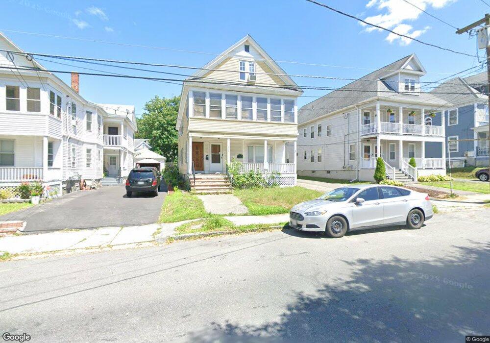
426 High St Lowell, MA 01852
Belvidere NeighborhoodEstimated Value: $748,000 - $894,000
8
Beds
2
Baths
2,916
Sq Ft
$277/Sq Ft
Est. Value
About This Home
This home is located at 426 High St, Lowell, MA 01852 and is currently estimated at $807,269, approximately $276 per square foot. 426 High St is a home located in Middlesex County with nearby schools including Moody Elementary School, Abraham Lincoln Elementary School, and Greenhalge Elementary School.
Ownership History
Date
Name
Owned For
Owner Type
Purchase Details
Closed on
Sep 12, 2022
Sold by
53-59 Pine Street Llc
Bought by
426-428 High Street Llc
Current Estimated Value
Purchase Details
Closed on
Apr 21, 2006
Sold by
Gary W Lafortune T W and Gary Lafortune
Bought by
Silva-Falcon Keylla
Home Financials for this Owner
Home Financials are based on the most recent Mortgage that was taken out on this home.
Original Mortgage
$294,000
Interest Rate
6.37%
Mortgage Type
Purchase Money Mortgage
Purchase Details
Closed on
Apr 30, 2001
Sold by
Lafortune Georgiana B and Lafortune Raymond
Bought by
Gary W Lafortune Trust and Lafortune Georgiana B
Home Financials for this Owner
Home Financials are based on the most recent Mortgage that was taken out on this home.
Original Mortgage
$42,000
Interest Rate
6.88%
Mortgage Type
Purchase Money Mortgage
Create a Home Valuation Report for This Property
The Home Valuation Report is an in-depth analysis detailing your home's value as well as a comparison with similar homes in the area
Home Values in the Area
Average Home Value in this Area
Purchase History
| Date | Buyer | Sale Price | Title Company |
|---|---|---|---|
| 426-428 High Street Llc | -- | None Available | |
| 426-428 High Street Llc | -- | None Available | |
| Silva-Falcon Keylla | $367,500 | -- | |
| Silva-Falcon Keylla | $367,500 | -- | |
| Gary W Lafortune Trust | $135,003 | -- | |
| Gary W Lafortune Trust | $135,003 | -- |
Source: Public Records
Mortgage History
| Date | Status | Borrower | Loan Amount |
|---|---|---|---|
| Previous Owner | Silva-Falcon Keylla | $294,000 | |
| Previous Owner | Gary W Lafortune Trust | $42,000 |
Source: Public Records
Tax History
| Year | Tax Paid | Tax Assessment Tax Assessment Total Assessment is a certain percentage of the fair market value that is determined by local assessors to be the total taxable value of land and additions on the property. | Land | Improvement |
|---|---|---|---|---|
| 2025 | $8,977 | $782,000 | $147,800 | $634,200 |
| 2024 | $8,481 | $712,100 | $150,900 | $561,200 |
| 2023 | $7,842 | $631,400 | $126,300 | $505,100 |
| 2022 | $7,260 | $572,100 | $114,800 | $457,300 |
| 2021 | $6,745 | $501,100 | $99,900 | $401,200 |
| 2020 | $6,282 | $470,200 | $99,900 | $370,300 |
| 2019 | $5,542 | $394,700 | $87,100 | $307,600 |
| 2018 | $7,135 | $359,100 | $83,000 | $276,100 |
| 2017 | $4,950 | $331,800 | $79,300 | $252,500 |
| 2016 | $4,860 | $320,600 | $68,100 | $252,500 |
| 2015 | $4,475 | $289,100 | $68,100 | $221,000 |
| 2013 | $3,922 | $261,300 | $86,600 | $174,700 |
Source: Public Records
Map
Nearby Homes
- 200 Rogers St Unit 6
- 44 Hanks St
- 234 Nesmith St Unit 8
- 158 Concord St
- 88 Perry St
- 313 Nesmith St
- 317 Nesmith St
- 31 Merrill St
- 39 Groves Ave
- 8 Cady St
- 189 Charles St
- 810 Lawrence St Unit C
- 21 Agawam St
- 5 Floyd St
- 42 Pentucket Ave
- 900 Lawrence St Unit 5
- 7 Butler Ave Unit 5
- 8 Cedar Ct
- 5 Lenox St Unit 2
- 5 Lenox St Unit 4
- 420 High St
- 430 High St
- 416 High St
- 416 High St Unit 1
- 434 High St
- 79 Sherman St
- 153 Fort Hill Ave
- 157 Fort Hill Ave
- 163 Fort Hill Ave
- 85 Sherman St
- 85 Sherman St Unit 3
- 85 Sherman St Unit 2
- 85 Sherman St Unit 1
- 433 High St
- 440 High St
- 421 High St
- 431 High St
- 423 High St Unit 423
- 171 Fort Hill Ave Unit 171
- 417 High St
Your Personal Tour Guide
Ask me questions while you tour the home.