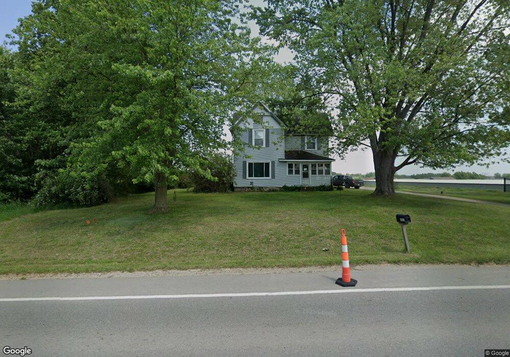
4263 Division St Wayland, MI 49348
Estimated Value: $314,723 - $394,000
--
Bed
2
Baths
1,968
Sq Ft
$181/Sq Ft
Est. Value
About This Home
This home is located at 4263 Division St, Wayland, MI 49348 and is currently estimated at $355,431, approximately $180 per square foot. 4263 Division St is a home located in Allegan County with nearby schools including Wayland High School, Moline Christian School, and St. Therese Catholic School.
Ownership History
Date
Name
Owned For
Owner Type
Purchase Details
Closed on
Sep 15, 2021
Sold by
Myers Kathy and Myers Kenneth
Bought by
Millstone Storage Llc
Current Estimated Value
Home Financials for this Owner
Home Financials are based on the most recent Mortgage that was taken out on this home.
Original Mortgage
$192,000
Outstanding Balance
$174,706
Interest Rate
2.8%
Mortgage Type
Future Advance Clause Open End Mortgage
Estimated Equity
$180,725
Create a Home Valuation Report for This Property
The Home Valuation Report is an in-depth analysis detailing your home's value as well as a comparison with similar homes in the area
Home Values in the Area
Average Home Value in this Area
Purchase History
| Date | Buyer | Sale Price | Title Company |
|---|---|---|---|
| Millstone Storage Llc | -- | First American Title |
Source: Public Records
Mortgage History
| Date | Status | Borrower | Loan Amount |
|---|---|---|---|
| Open | Millstone Storage Llc | $192,000 |
Source: Public Records
Tax History Compared to Growth
Tax History
| Year | Tax Paid | Tax Assessment Tax Assessment Total Assessment is a certain percentage of the fair market value that is determined by local assessors to be the total taxable value of land and additions on the property. | Land | Improvement |
|---|---|---|---|---|
| 2025 | $5,628 | $134,000 | $21,500 | $112,500 |
| 2024 | $5,139 | $130,200 | $18,900 | $111,300 |
| 2023 | $5,139 | $114,500 | $18,900 | $95,600 |
| 2022 | $5,139 | $102,900 | $18,900 | $84,000 |
| 2021 | $1,485 | $95,700 | $19,400 | $76,300 |
| 2020 | $74 | $90,400 | $19,400 | $71,000 |
| 2019 | $76 | $81,600 | $18,000 | $63,600 |
| 2018 | $76 | $77,200 | $18,000 | $59,200 |
| 2017 | $0 | $73,100 | $18,000 | $55,100 |
| 2016 | $0 | $59,200 | $18,000 | $41,200 |
| 2015 | -- | $59,200 | $18,000 | $41,200 |
| 2014 | -- | $54,400 | $17,200 | $37,200 |
| 2013 | $1,497 | $51,500 | $17,200 | $34,300 |
Source: Public Records
Map
Nearby Homes
- 4273 Highpoint Dr Unit 112
- Unit 111 Highpoint Dr
- 4274 Butternut Dr
- Lot 142 Butternut Dr
- Lot 141 Butternut Dr
- 4240 Butternut Dr
- Vienna Plan at Harvest Meadows
- Charlotte Plan at Harvest Meadows
- Sierra Plan at Harvest Meadows
- Karolynn Plan at Harvest Meadows
- Reno Plan at Harvest Meadows
- Bayberry Plan at Harvest Meadows
- Freedom Plan at Harvest Meadows
- London Plan at Harvest Meadows
- Hampton Plan at Harvest Meadows
- Oxford Plan at Harvest Meadows
- 4249 Butternut Dr
- 4245 Butternut Dr
- 4243 Butternut Dr
- 4316 Sussex Place
- 4266 Division St
- 4266 Division St
- 1092 Countryair Dr Unit 3
- 1094 Countryair Dr Unit 2
- 1090 Countryair Dr Unit 4
- 1096 Countryair Dr Unit 1
- 1086 Countryair Dr Unit 5
- 1084 Countryair Dr Unit 6
- 1082 Countryair Dr Unit 7
- 1080 Countryair Dr Unit 8
- 1093 Countryair Dr Unit 44
- 1095 Countryair Dr Unit 45
- 1097 Countryair Dr Unit 46
- 4264 Cloverfield Ct
- 4272 Cidermill Dr Unit 41
- 4260 Cloverfield Ct
- 4274 Cidermill Dr Unit 40
- 4269 Cidermill Dr Unit 9
- 4256 Cloverfield Ct
- 4271 Cidermill Dr Unit 10