Estimated Value: $201,000 - $249,000
3
Beds
2
Baths
1,280
Sq Ft
$180/Sq Ft
Est. Value
About This Home
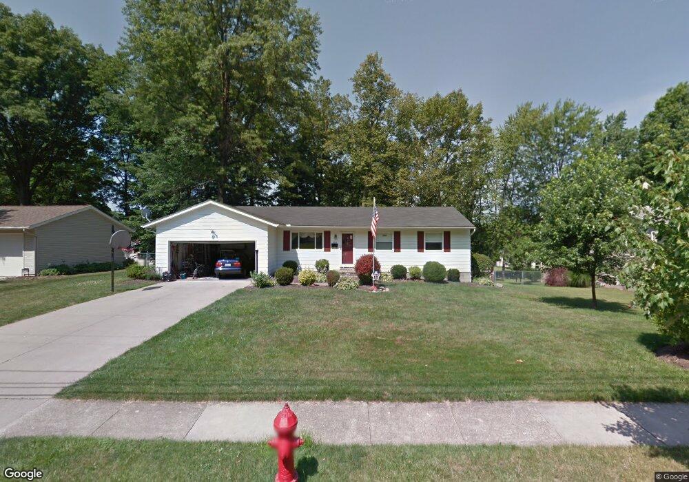
This home is located at 4264 Maplepark Rd, Stow, OH 44224 and is currently estimated at $230,007, approximately $179 per square foot. 4264 Maplepark Rd is a home located in Summit County with nearby schools including Stow-Munroe Falls High School, Holy Family Elementary School, and Walsh Jesuit High School.
Ownership History
Date
Name
Owned For
Owner Type
Purchase Details
Closed on
May 13, 1997
Sold by
Dawes Douglas P
Bought by
Baker Robert J and Baker Kathryn E
Current Estimated Value
Home Financials for this Owner
Home Financials are based on the most recent Mortgage that was taken out on this home.
Original Mortgage
$97,665
Outstanding Balance
$13,434
Interest Rate
8.05%
Mortgage Type
New Conventional
Estimated Equity
$216,573
Create a Home Valuation Report for This Property
The Home Valuation Report is an in-depth analysis detailing your home's value as well as a comparison with similar homes in the area
Home Values in the Area
Average Home Value in this Area
Purchase History
| Date | Buyer | Sale Price | Title Company |
|---|---|---|---|
| Baker Robert J | $114,900 | -- |
Source: Public Records
Mortgage History
| Date | Status | Borrower | Loan Amount |
|---|---|---|---|
| Open | Baker Robert J | $97,665 |
Source: Public Records
Tax History
| Year | Tax Paid | Tax Assessment Tax Assessment Total Assessment is a certain percentage of the fair market value that is determined by local assessors to be the total taxable value of land and additions on the property. | Land | Improvement |
|---|---|---|---|---|
| 2024 | $3,888 | $68,712 | $13,139 | $55,573 |
| 2023 | $3,888 | $68,712 | $13,139 | $55,573 |
| 2022 | $3,329 | $51,846 | $9,881 | $41,965 |
| 2021 | $2,983 | $51,846 | $9,881 | $41,965 |
| 2020 | $2,932 | $51,850 | $9,880 | $41,970 |
| 2019 | $2,716 | $44,820 | $9,880 | $34,940 |
| 2018 | $3,391 | $44,820 | $9,880 | $34,940 |
| 2017 | $4,178 | $44,820 | $9,880 | $34,940 |
| 2016 | $2,633 | $41,690 | $9,880 | $31,810 |
| 2015 | $4,178 | $41,690 | $9,880 | $31,810 |
| 2014 | $3,203 | $41,690 | $9,880 | $31,810 |
| 2013 | $3,931 | $41,810 | $9,880 | $31,930 |
Source: Public Records
Map
Nearby Homes
- 4287 Osage St
- 4205 Osage St
- 2344 Echo Valley Dr
- 4138 Genevieve Blvd
- 4556 Fishcreek Rd
- 4544 Fishcreek Rd
- 4040 Burton Dr
- 4534 Foresthill Rd
- 4003 Kenneth Rd
- 2419 Liberty Rd
- 2055-2059 Bryn Mawr Dr
- 0 Vira Rd
- 4424 Timberdale Dr Unit 4428
- 3846 Charring Cross Dr
- 2535 Sears Rd
- 1969 Conwill Rd Unit 1973
- 3820 Seneca St
- 3828 Osage St Unit 3832
- 3958 Lake Run Blvd
- 1953 Arndale Rd
- 4274 Maplepark Rd
- 4256 Maplepark Rd
- 4247 Osage St
- 4239 Osage St
- 4248 Maplepark Rd
- 4282 Maplepark Rd
- 4253 Osage St
- 4265 Maplepark Rd
- 4275 Maplepark Rd
- 4233 Osage St
- 4255 Maplepark Rd
- 4261 Osage St
- 4225 Osage St
- 4292 Maplepark Rd
- 4247 Maplepark Rd
- 4267 Osage St
- 4236 Maplepark Rd
- 4290 Brixton Dr
- 2405 Norman Dr
- 4276 Brixton Dr
Your Personal Tour Guide
Ask me questions while you tour the home.