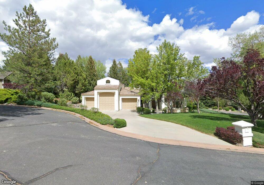
4265 Grubstake Cir Reno, NV 89519
Juniper Trails NeighborhoodEstimated Value: $1,395,913 - $1,663,000
4
Beds
4
Baths
3,503
Sq Ft
$447/Sq Ft
Est. Value
About This Home
This home is located at 4265 Grubstake Cir, Reno, NV 89519 and is currently estimated at $1,565,228, approximately $446 per square foot. 4265 Grubstake Cir is a home located in Washoe County with nearby schools including Roy Gomm Elementary School, Darrell C Swope Middle School, and Reno High School.
Ownership History
Date
Name
Owned For
Owner Type
Purchase Details
Closed on
Apr 12, 2007
Sold by
Herkal Walter H and Herkal Dalemarie
Bought by
Herkal Walter H and Herkal Dalemarie
Current Estimated Value
Purchase Details
Closed on
Feb 4, 2001
Sold by
Keifer Gerald B and Keifer Lanette A
Bought by
Herkal Walter H and Herkal Dalemarie
Create a Home Valuation Report for This Property
The Home Valuation Report is an in-depth analysis detailing your home's value as well as a comparison with similar homes in the area
Home Values in the Area
Average Home Value in this Area
Purchase History
| Date | Buyer | Sale Price | Title Company |
|---|---|---|---|
| Herkal Walter H | -- | None Available | |
| Herkal Walter H | $510,000 | Stewart Title Northern Nevad |
Source: Public Records
Tax History Compared to Growth
Tax History
| Year | Tax Paid | Tax Assessment Tax Assessment Total Assessment is a certain percentage of the fair market value that is determined by local assessors to be the total taxable value of land and additions on the property. | Land | Improvement |
|---|---|---|---|---|
| 2025 | $8,618 | $329,047 | $110,250 | $218,797 |
| 2024 | $8,618 | $324,401 | $102,200 | $222,201 |
| 2023 | $8,367 | $311,703 | $99,750 | $211,953 |
| 2022 | $8,130 | $270,864 | $92,750 | $178,114 |
| 2021 | $7,899 | $251,824 | $73,500 | $178,324 |
| 2020 | $7,663 | $253,278 | $73,500 | $179,778 |
| 2019 | $7,440 | $251,910 | $73,500 | $178,410 |
| 2018 | $7,225 | $243,563 | $68,250 | $175,313 |
| 2017 | $7,014 | $237,666 | $61,250 | $176,416 |
| 2016 | $6,835 | $233,066 | $52,500 | $180,566 |
| 2015 | $6,825 | $221,600 | $39,375 | $182,225 |
| 2014 | $6,625 | $206,487 | $28,000 | $178,487 |
| 2013 | -- | $204,084 | $28,000 | $176,084 |
Source: Public Records
Map
Nearby Homes
- 4292 Caughlin Pkwy
- 4120 Flintlock Cir
- 4283 Water Hole Rd
- 4229 Christy Way
- 1860 Hunter Creek Rd
- 60 Promontory Pointe
- 3911 N Westpoint Dr
- 4315 Water Hole Rd
- 4840 Keshmiri Place
- 1720 Hunter Creek Rd Unit 5
- 1005 Stag Ridge Ct Unit 5
- 3332 Deer Ridge Ct
- 30 Francovich Ct
- 1570 Caughlin Creek Rd
- 3790 Ranch Crest Dr
- 4940 Turning Leaf Way Unit 3
- 3678 Brighton Way
- 4265 Hackamore Dr
- 3744 Ranch Crest Dr Unit 1
- 1074 Waverly Dr
- 4263 Greenhorn Cir
- 4267 Grubstake Cir
- 4260 Caughlin Pkwy Unit 4
- 4273 Grubstake Cir
- 4266 Caughlin Pkwy
- 4259 Greenhorn Cir
- 4269 Grubstake Cir
- 4270 Caughlin Pkwy
- 4256 Caughlin Pkwy
- 4275 Caughlin Pkwy
- 3960 Plateau Rd
- 4255 Greenhorn Cir
- 4250 Caughlin Pkwy
- 4272 Caughlin Pkwy Unit 4
- 4274 Bitteroot Rd
- 3950 Plateau Rd
- 4225 Buckaroo Cir
- 3980 Plateau Rd
- 4273 Bitteroot Rd
- 4324 Aspenwood Ct