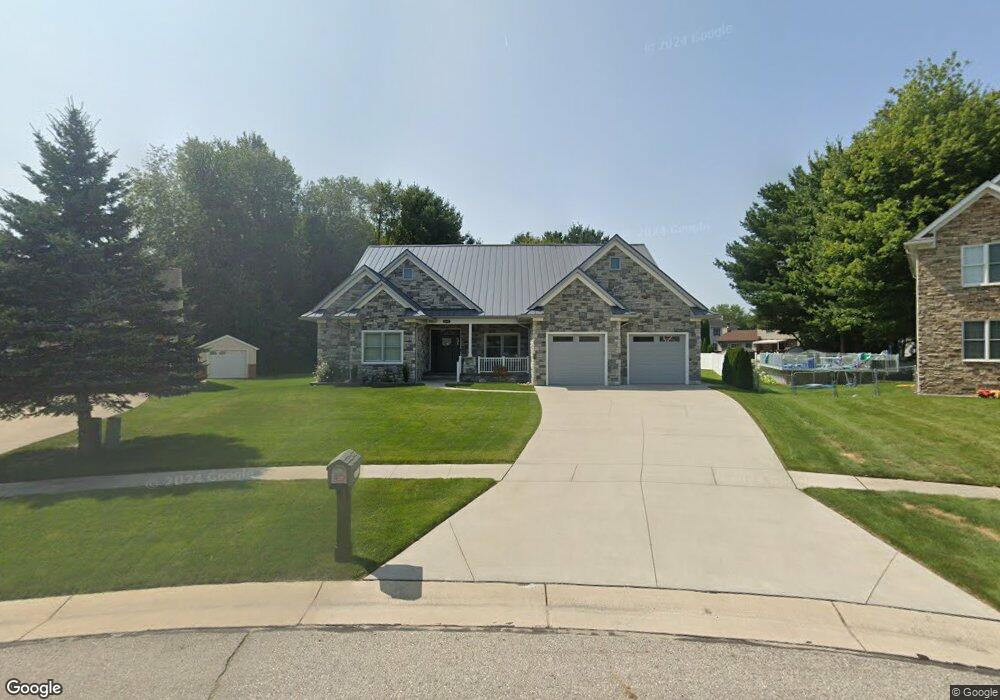
4267 Meadow Ct Port Huron, MI 48060
Estimated Value: $521,000 - $549,185
3
Beds
3
Baths
2,500
Sq Ft
$213/Sq Ft
Est. Value
About This Home
This home is located at 4267 Meadow Ct, Port Huron, MI 48060 and is currently estimated at $532,796, approximately $213 per square foot. 4267 Meadow Ct is a home located in St. Clair County with nearby schools including Michigamme Elementary School, Central Middle School, and Port Huron High School.
Ownership History
Date
Name
Owned For
Owner Type
Purchase Details
Closed on
Mar 11, 2025
Sold by
Lorf Gary and Lorf Laurie
Bought by
Hamilton Robert and Hamilton Kim
Current Estimated Value
Purchase Details
Closed on
Nov 23, 2016
Sold by
Kemp Daniel and Kemp Tara N
Bought by
Lorf Gary and Lorf Laurie
Purchase Details
Closed on
Sep 4, 2007
Sold by
M & F Eneterprises Llc
Bought by
Kemp Daniel and Kemp Tara
Create a Home Valuation Report for This Property
The Home Valuation Report is an in-depth analysis detailing your home's value as well as a comparison with similar homes in the area
Home Values in the Area
Average Home Value in this Area
Purchase History
| Date | Buyer | Sale Price | Title Company |
|---|---|---|---|
| Hamilton Robert | $519,900 | Service One Title | |
| Hamilton Robert | $519,900 | Service One Title | |
| Lorf Gary | $25,000 | None Available | |
| Kemp Daniel | $45,000 | None Available |
Source: Public Records
Tax History Compared to Growth
Tax History
| Year | Tax Paid | Tax Assessment Tax Assessment Total Assessment is a certain percentage of the fair market value that is determined by local assessors to be the total taxable value of land and additions on the property. | Land | Improvement |
|---|---|---|---|---|
| 2025 | $6,505 | $230,600 | $0 | $0 |
| 2024 | $3,423 | $244,800 | $0 | $0 |
| 2023 | $3,159 | $213,300 | $0 | $0 |
| 2022 | $5,836 | $167,500 | $0 | $0 |
| 2021 | $5,414 | $165,700 | $0 | $0 |
| 2020 | $5,414 | $165,500 | $0 | $165,500 |
| 2019 | $5,313 | $14,500 | $0 | $0 |
| 2018 | $4,116 | $14,500 | $0 | $0 |
| 2017 | $747 | $14,500 | $0 | $0 |
| 2016 | $489 | $14,500 | $0 | $0 |
| 2015 | -- | $13,700 | $13,700 | $0 |
| 2014 | -- | $13,700 | $13,700 | $0 |
| 2013 | -- | $13,700 | $0 | $0 |
Source: Public Records
Map
Nearby Homes
- 3115 Spruce Dr
- 3152 Spruce Dr
- 4224 Atkins Rd
- 4361 Peck Rd
- 3230 Range Rd
- 3345 Beach Rd
- 4608 Huntington Dr
- 2863 Beach Rd
- 4460 Cambridge Dr
- 3971 N River Rd
- 0000 W Water St
- 3993 N River Rd
- 4167 N River Rd
- 3610 State Rd
- 4224 N River Rd
- 3580 Angus Rd
- 2940 Westland Dr
- 4570 Atkins Rd
- 4380 Lapeer Rd
- 3625 Angus Rd
- 4275 Meadow Ct
- 4259 Meadow Ct
- 17 Spruce Dr
- 3133 Spruce Dr
- 00 Conifer Ln
- 0000 Conifer Ln
- 0 Conifer Ln
- 4274 Meadow Ct
- 4274 Meadow Ct Unit 23
- 3262 Amberwood Dr
- 3254 Amberwood Dr
- 4251 Meadow Ct
- 3246 Amberwood Dr
- 0 Meadow Ct
- 3270 Amberwood Dr
- 3141 Spruce Dr
- 3238 Amberwood Dr
- 4268 Meadow Ct
- 3278 Amberwood Dr
- Unit 26 Meadow Ct