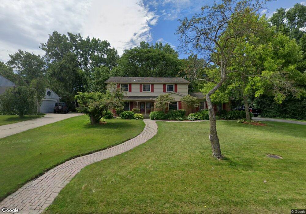
4267 Pinehurst Dr West Bloomfield, MI 48322
Estimated Value: $467,000 - $541,000
4
Beds
4
Baths
2,790
Sq Ft
$180/Sq Ft
Est. Value
About This Home
This home is located at 4267 Pinehurst Dr, West Bloomfield, MI 48322 and is currently estimated at $501,399, approximately $179 per square foot. 4267 Pinehurst Dr is a home located in Oakland County with nearby schools including Sheiko Elementary School, Sarah & Irving Pitt Child Development Center, and Bloomfield Maples Montessori.
Ownership History
Date
Name
Owned For
Owner Type
Purchase Details
Closed on
Sep 15, 2022
Sold by
Moore Mcgriff Letha Vanessa
Bought by
Letha Vanessa Moore Mcgriff Revocable Living
Current Estimated Value
Purchase Details
Closed on
Jun 24, 2009
Sold by
Schaeffer Lloyd E and Schaeffer Susan E
Bought by
Mcgriff Letha
Create a Home Valuation Report for This Property
The Home Valuation Report is an in-depth analysis detailing your home's value as well as a comparison with similar homes in the area
Home Values in the Area
Average Home Value in this Area
Purchase History
| Date | Buyer | Sale Price | Title Company |
|---|---|---|---|
| Letha Vanessa Moore Mcgriff Revocable Living | -- | -- | |
| Mcgriff Letha | $258,000 | Capital Title Ins Agency |
Source: Public Records
Tax History
| Year | Tax Paid | Tax Assessment Tax Assessment Total Assessment is a certain percentage of the fair market value that is determined by local assessors to be the total taxable value of land and additions on the property. | Land | Improvement |
|---|---|---|---|---|
| 2025 | $5,189 | $211,540 | $53,330 | $158,210 |
| 2024 | $3,233 | $207,550 | $0 | $0 |
| 2022 | $3,096 | $172,980 | $39,500 | $133,480 |
| 2021 | $4,705 | $165,200 | $0 | $0 |
| 2020 | $3,034 | $161,340 | $39,500 | $121,840 |
| 2018 | $4,536 | $144,820 | $34,350 | $110,470 |
| 2015 | -- | $126,210 | $0 | $0 |
| 2014 | -- | $116,750 | $0 | $0 |
| 2011 | -- | $110,470 | $0 | $0 |
Source: Public Records
Map
Nearby Homes
- 4205 Pinehurst Dr
- 6322 Pepper Hill St Unit 62
- 6298 Aspen Ridge Blvd Unit 34
- 6151 Orchard Lake Rd Unit 103
- 6076 Dunmore Dr
- 5865 Dunmore Ct
- 6610 Fieldstone Ct
- 6622 Fieldstone Ct
- 6651 Hearthside Ct Unit 1
- 3865 Stonecrest Rd
- 6843 Leslee Crest Dr
- 5731 Farmington Rd
- 3472 Winchester Rd
- 4819 Thorntree Dr
- 6323 Potomac Cir Unit 22
- 5586 Wild Ridge Ln
- 23617 Trailview Dr Unit 29
- 23601 Trailview Dr Unit 37
- 6020 Northfield Rd
- 5106 Rock Run
- 4253 Pinehurst Dr
- 4281 Pinehurst Dr
- 6243 Pinecroft Dr
- 6274 Aspen Ridge Blvd Unit 29
- 4237 Pinehurst Dr
- 6265 Pinecroft Dr
- 4270 Pinehurst Dr
- 4254 Pinehurst Dr
- 4286 Pinehurst Dr
- 6306 Aspen Ridge Blvd
- 6306 Aspen Ridge Blvd Unit 23
- 4238 Pinehurst Dr
- 6287 Pinecroft Dr
- 4221 Pinehurst Dr
- 4323 Pinehurst Dr
- 4222 Pinehurst Dr
- 4302 Pinehurst Dr
- 6244 Pinecroft Dr
- 4223 Pinecroft Ct
- 4241 Pinecroft Ct
Your Personal Tour Guide
Ask me questions while you tour the home.