NOT LISTED FOR SALE

4268 W 1325 S Unit 4 Cedar City, UT 84720

Estimated Value: $717,932 - $776,000

0.52 Acre
$1,441,794 Price per Acre
22,651 Sq Ft Lot

Last Sold January 23, 2016

Current estimated payment $4,445/month

477 Days on Market

About This Lot

As of January 2016

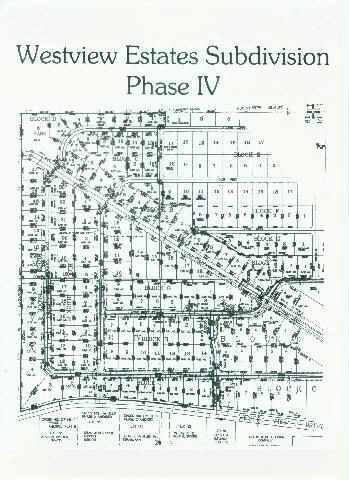
Uncommonly great lot with unprecedented amenities. Within the county. Save thousands of dollars on impact fees. Great building opportunity in a nicely improved subdivision. Curb, gutter sidewalks and all your favorite utilities in a quiet country setting. Breathtaking views all around. Just minutes away from downtown Cedar City and SUU (Southern Utah University). *Pictures are of lots in Westview subdivision, however many not be of actual lot.

Last Agent to Sell the Property

Michelle Halladay

ERA Realty Center License #8436259-SA00 Listed on: 09/14/2015

ERA Realty Center

Co-Listed By

DAVE TAYLOR

ERA Realty Center

Last Buyer's Agent

SCOTT ZELLER

ELEMENT REAL ESTATE BROKERS LL License #13409369-SA00

Property Details

Property Type

  • Land

Est. Annual Taxes

  • $334

Lot Details

  • 0.52 Acre Lot
  • Brush Vegetation
  • Level Lot
  • Property is zoned R-1/2

Community Details

  • Property has a Home Owners Association
  • Westview Estates Subdivision

Listing and Financial Details

  • Legal Lot and Block 16 / F
  • Assessor Parcel Number D-1213-000F-0016

Property Details

Property Type

Land

Est. Annual Taxes

$334

Lot Details

0

Listing Details

  • Prop. Type: Land
  • Reso Property Sub Type: Lot
  • Road Surface Type: Paved, County Maintained, Public Access
  • Co List Office Mls Id: ERAREALTY
  • Subdivision Name: Westview Estates
  • Master Plan Zoning: R-1/2
  • Terrain Flat: Yes
  • Terrain Gradual Slope: Yes
  • Utilities Natural Gas Available: Yes
  • Utilities Electric-City: Yes
  • VegetationCrops:Sage Brush: Yes
  • VegetationCrops:Dry Farm: Yes
  • SewerSeptic Sewer-Available: Yes
  • Special Features: None
  • Property Sub Type: LotsLands

Exterior Features

  • Acres: 0.52

Condo/Co-op/Association

  • Senior Community: No
  • Association Fee: 40.0
  • Association: Yes

Lot Info

  • Parcel #: D-1213-000F-0016
  • Lot Size Sq Ft: 22651.2
  • ResoLotSizeUnits: Acres
  • ResoLotSizeUnits: Acres

Tax Info

  • Tax Annual Amount: 334.09
  • Tax Block: F
  • Tax Lot: 16

Ownership History

Date Name Owned For Owner Type

Purchase Details

Closed on
Mar 3, 2020
Sold by
Kaustinen Randall J and Kaustinen Claudia C
Bought by
Kaustinen Randall J and Kaustinen Claudia C
Current Estimated Value
$749,733

Home Financials for this Owner

Home Financials are based on the most recent Mortgage that was taken out on this home.
Original Mortgage
$240,000
Outstanding Balance
$211,699
Interest Rate
3.6%
Mortgage Type
New Conventional
Estimated Equity
$536,428

Purchase Details

Closed on
Mar 2, 2020
Sold by
Kaustinen Randall J and Kaustinen Claudia C
Bought by
Kaustinen Randall J and Kaustinen Claudia C

Home Financials for this Owner

Home Financials are based on the most recent Mortgage that was taken out on this home.
Original Mortgage
$240,000
Outstanding Balance
$211,699
Interest Rate
3.6%
Mortgage Type
New Conventional
Estimated Equity
$536,428

Purchase Details

Closed on
Dec 18, 2018
Sold by
Kaustinen Randall J and Kaustinen Claudia C
Bought by
Kaustinen Randall J and Kaustinen Claudia C

Purchase Details

Closed on
Jan 5, 2017
Sold by
Southern Dixie Investment Inc
Bought by
Kaustinen Randall J and Kaustinen Claudia C

Home Financials for this Owner

Home Financials are based on the most recent Mortgage that was taken out on this home.
Original Mortgage
$218,569
Interest Rate
4.03%
Mortgage Type
New Conventional

Purchase Details

Closed on
Aug 22, 2016
Sold by
Kaustinen Randall J and Kaustinen Claudia C
Bought by
Southern Dixie Investment Inc
Source: Public Records

Similar Properties in Cedar City, UT

  • Lot#1 S Main St, Cedar City, UT 84720

    $810,450

    • Land
    • 0.62 Acre
    • $1,307,177 per Acre
    • Lot#1 S Main St
    • Cedar City, UT

    Cedar Creek Subdivision, Phase 1, Lot 1, 0.62 Acre property located on South Main Street with frontage. Pads are estimated for completion Fall of 2024. Zoning is Central Commercial. Lot #1 is prime for a possible drive thru. This site is roughly a quarter of a mile from the I-15 with freeway visibility.

    KAYLA CROSBY SUPERIOR REAL ESTATE SALES.COM

    Section Image
  • 1 S Main St, Cedar City, UT 84720

    $810,450

    • Land
    • 0.62 Acre
    • $1,307,177 per Acre
    • 1 S Main St
    • Cedar City, UT

    Cedar Creek Subdivision, Phase 1, lot#1, 0.62 Acre property located on South Cedar City Main Street with Main Street frontage. Pads are estimated to be completed Fall of 2024. Zoning is Central Commercial.Lot #1 is prime for possible drive thru. The site is roughly a quarter of a mile from the I-15 with freeway visibility.

    KAYLA CROSBY SUPERIOR REAL ESTATE SALES.COM

    Section Image

Range of Values:

Collateral Analytics

Collateral Analytics Collateral Analytics AVMs (Automated Valuation Model) employ a number of statistical approaches combined with neighborhood-specific comparable selection guarantees the most up-to-date and precise valuations.

Not Available

Collateral Analytics does not have data for the current month. Please view the chart for historical values.

ICE

ICE Mortgage Technology ICE Mortgage Technology’s AVM (Automated Valuation Model) is a state-of-the-art online residential property valuation tool that provides a quick and accurate estimate of the value of almost any home in the U.S.

Not Available

ICE Mortgage Technology does not have data for the current month. Please view the chart for historical values.

First American

First American First American Data & Analytics’ next-generation AVM combines unrivaled data assets with a blended ensemble of valuation models to produce highly accurate, reliable valuations you can trust.

Not Available

First American does not have data for the current month. Please view the chart for historical values.

Quantarium

Quantarium Quantarium’s valuation service, repeatedly proven the industry’s most accurate and comprehensive, is supercharged with a self-learning and auto-tuning AI engine that continually becomes smarter and more accurate as it processes daily inputs from the industry’s leading RE data lake.

Not Available

Quantarium does not have data for the current month. Please view the chart for historical values.

Average Value
Not Available
List Price
Sold Price
Create a Home Valuation Report for This Property
The Home Valuation Report is an in-depth analysis detailing your home's value as well as a comparison with similar homes in the area

Home Values in the Area

Source: Public Records

Average Home Value in this Area


Source: Public Records

Purchase History

Date Buyer Sale Price Title Company
Kaustinen Randall J -- Inwest Title Services
Kaustinen Randall J -- Accommodation
Kaustinen Randall J -- None Available
Kaustinen Randall J -- Security Escrow & Title Insu
Southern Dixie Investment Inc -- Security Escrow & Title Insu
Source: Public Records

Mortgage History

Date Status Borrower Loan Amount
Open Kaustinen Randall J $240,000
Closed Kaustinen Randall J $218,569
Previous Owner Southern Dixie Investment Inc $186,200
Previous Owner Kaustinen Randall J $38,610
Source: Public Records

Property History

Date Event Price Change Sq Ft Price
01/23/2016 01/23/16 Sold -- -- --
10/24/2015 10/24/15 Pending -- -- --
07/04/2014 07/04/14 For Sale $39,900 -- --
Source: Iron County Board of REALTORS®

Tax History Compared to Growth

Source: Public Records

Tax History

Year Tax Paid Tax Assessment Tax Assessment Total Assessment is a certain percentage of the fair market value that is determined by local assessors to be the total taxable value of land and additions on the property. Land Improvement
2023 $3,227 $474,450 $76,025 $398,425
2022 $3,050 $340,945 $63,355 $277,590
2021 $2,767 $309,265 $31,675 $277,590
2020 $3,079 $304,800 $31,675 $273,125
2019 $2,878 $273,190 $29,330 $243,860
2018 $2,677 $248,220 $25,730 $222,490
2017 $2,519 $234,075 $24,670 $209,405
2016 $435 $36,455 $36,455 $0
2015 $419 $33,540 $0 $0
2014 $404 $30,490 $0 $0
Source: Public Records

Agents Affiliated with this Home

  • Section Image
  • Section Image
See All Agents

Map

Source: Iron County Board of REALTORS®

MLS Number: 68868

APN: D-1213-000F-0016