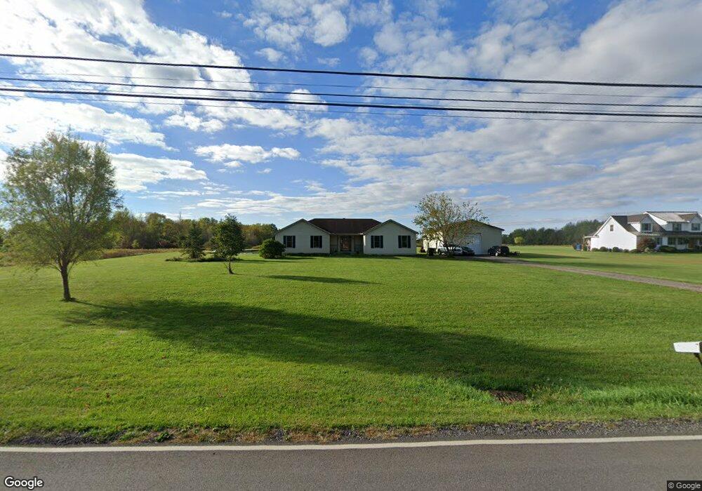
42695 Webster Rd Lagrange, OH 44050
Estimated Value: $289,000 - $404,508
3
Beds
2
Baths
1,720
Sq Ft
$212/Sq Ft
Est. Value
About This Home
This home is located at 42695 Webster Rd, Lagrange, OH 44050 and is currently estimated at $364,127, approximately $211 per square foot. 42695 Webster Rd is a home located in Lorain County with nearby schools including Keystone Elementary School, Keystone Middle School, and Keystone High School.
Ownership History
Date
Name
Owned For
Owner Type
Purchase Details
Closed on
May 10, 2004
Sold by
David Development Inc
Bought by
Mclaughlin Martin M and Mclaughlin Marie E
Current Estimated Value
Home Financials for this Owner
Home Financials are based on the most recent Mortgage that was taken out on this home.
Original Mortgage
$197,100
Interest Rate
5.63%
Mortgage Type
Construction
Create a Home Valuation Report for This Property
The Home Valuation Report is an in-depth analysis detailing your home's value as well as a comparison with similar homes in the area
Purchase History
| Date | Buyer | Sale Price | Title Company |
|---|---|---|---|
| Mclaughlin Martin M | -- | Lorain County Title Co Inc |
Source: Public Records
Mortgage History
| Date | Status | Borrower | Loan Amount |
|---|---|---|---|
| Closed | Mclaughlin Martin M | $197,100 |
Source: Public Records
Tax History Compared to Growth
Tax History
| Year | Tax Paid | Tax Assessment Tax Assessment Total Assessment is a certain percentage of the fair market value that is determined by local assessors to be the total taxable value of land and additions on the property. | Land | Improvement |
|---|---|---|---|---|
| 2024 | $4,803 | $112,973 | $26,922 | $86,051 |
| 2023 | $4,575 | $88,606 | $22,897 | $65,709 |
| 2022 | $4,544 | $88,606 | $22,897 | $65,709 |
| 2021 | $4,544 | $88,606 | $22,897 | $65,709 |
| 2020 | $4,219 | $73,530 | $19,000 | $54,530 |
| 2019 | $4,164 | $73,530 | $19,000 | $54,530 |
| 2018 | $4,082 | $73,530 | $19,000 | $54,530 |
| 2017 | $3,983 | $65,490 | $17,750 | $47,740 |
| 2016 | $3,958 | $65,490 | $17,750 | $47,740 |
| 2015 | $3,936 | $65,490 | $17,750 | $47,740 |
| 2014 | $3,233 | $61,210 | $16,590 | $44,620 |
| 2013 | $3,096 | $61,210 | $16,590 | $44,620 |
Source: Public Records
Map
Nearby Homes
- 131 Walleye Ct
- 468 Stallion Ct
- 476 Stallion Ct
- 510 Arabian Ct
- 511 Arabian Ct
- 43311 Peck Wadsworth Rd
- 0 West Rd Unit 5125531
- 0 Ohio 301
- 110 Railroad St
- 43902 State Route 303
- 17880 Hawley Rd
- 16974 Hawley Rd
- 0 Dill Ct Unit 5072837
- 171 Keywood Blvd
- 407 Barker St
- 516 Appomattox Ct
- 139 Adams St
- 639 N Main St
- 231 Liberty Ln
- 132 Hale St
- 42741 Webster Rd
- 42688 Webster Rd
- 42666 Webster Rd
- 42615 Webster Rd
- 42644 Webster Rd
- 42620 Webster Rd
- 42805 Webster Rd
- 42592 Webster Rd
- 42605 Webster Rd
- 42578 Webster Rd
- 42558 Webster Rd
- 42845 Webster Rd
- 42538 Webster Rd
- 280 E Lake Dr
- 42535 Webster Rd
- 42520 Webster Rd
- 277 E Lake Dr
- 42494 Webster Rd
- 42860 Webster Rd
- 277 Horseshoe Dr