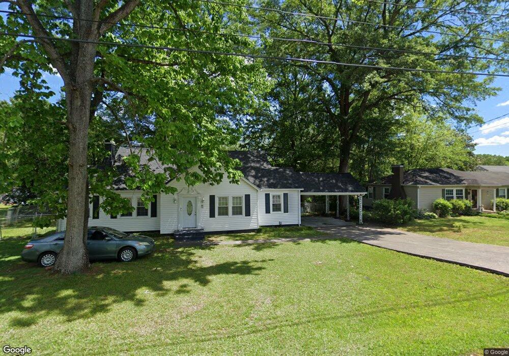
427 Barbara Ave Dalton, GA 30721
Estimated Value: $210,000 - $244,000
3
Beds
2
Baths
1,567
Sq Ft
$143/Sq Ft
Est. Value
About This Home
This home is located at 427 Barbara Ave, Dalton, GA 30721 and is currently estimated at $224,027, approximately $142 per square foot. 427 Barbara Ave is a home located in Whitfield County with nearby schools including Blue Ridge Elementary School, Dalton Middle School, and Dalton High School.
Ownership History
Date
Name
Owned For
Owner Type
Purchase Details
Closed on
Sep 29, 2006
Sold by
Perez Victor
Bought by
Perez Hortensia
Current Estimated Value
Home Financials for this Owner
Home Financials are based on the most recent Mortgage that was taken out on this home.
Original Mortgage
$91,550
Outstanding Balance
$54,327
Interest Rate
6.36%
Mortgage Type
New Conventional
Estimated Equity
$169,700
Purchase Details
Closed on
Mar 6, 2001
Sold by
Hicks Jeffery Brian
Bought by
Perez Victor
Purchase Details
Closed on
Jan 1, 1995
Bought by
Hicks Jeffery Brian
Create a Home Valuation Report for This Property
The Home Valuation Report is an in-depth analysis detailing your home's value as well as a comparison with similar homes in the area
Home Values in the Area
Average Home Value in this Area
Purchase History
| Date | Buyer | Sale Price | Title Company |
|---|---|---|---|
| Perez Hortensia | $94,398 | -- | |
| Perez Victor | $91,500 | -- | |
| Hicks Jeffery Brian | -- | -- |
Source: Public Records
Mortgage History
| Date | Status | Borrower | Loan Amount |
|---|---|---|---|
| Open | Perez Hortensia | $91,550 |
Source: Public Records
Tax History Compared to Growth
Tax History
| Year | Tax Paid | Tax Assessment Tax Assessment Total Assessment is a certain percentage of the fair market value that is determined by local assessors to be the total taxable value of land and additions on the property. | Land | Improvement |
|---|---|---|---|---|
| 2024 | $2,221 | $80,183 | $8,400 | $71,783 |
| 2023 | $2,221 | $65,893 | $17,500 | $48,393 |
| 2022 | $930 | $34,405 | $6,600 | $27,805 |
| 2021 | $932 | $34,405 | $6,600 | $27,805 |
| 2020 | $956 | $34,405 | $6,600 | $27,805 |
| 2019 | $982 | $34,405 | $6,600 | $27,805 |
| 2018 | $991 | $34,405 | $6,600 | $27,805 |
| 2017 | $948 | $34,405 | $6,600 | $27,805 |
| 2016 | $810 | $30,509 | $5,124 | $25,385 |
| 2014 | $778 | $30,509 | $5,124 | $25,385 |
| 2013 | -- | $30,508 | $5,124 | $25,384 |
Source: Public Records
Map
Nearby Homes
- 430 Lester Ave
- 406 Lester Ave
- 1902 Bartenfield Dr
- 514 Sheridan Ave
- trac 2 Roosevelt Dr
- trac 3 Roosevelt Dr
- 0 Robinwood Dr
- 1007 Locke Dr
- 1629 Roosevelt Dr
- 0 Dogwood Dr
- 1118 Dozier St
- 143 Staten St
- 1412 Stevenson Dr
- Lot 5 River Bend Rd
- Lot 4 Riverbend Rd
- Lot 7 Riverbend Rd
- 359 Pacer Ln Unit 4
- 359 Pacer Ln
- 303 Janice St
- 902 Mattie Dr
- 429 Barbara Ave
- 430 Barbara Ave
- 428 Barbara Ave
- 423 Barbara Ave
- 500 Barbara Ave
- 501 Barbara Ave
- 1519 Byron St
- 420 Barbara Ave
- 426 Lester Ave
- 421 Barbara Ave
- 424 Lester Ave
- 428 Lester Ave
- 418 Barbara Ave
- 29L Barbara Ave
- 419 Barbara Ave
- 502 Lester Ave
- 504 Lester Ave
- 507 Barbara Ave
- 422 Lester Ave
- 417 Barbara Ave