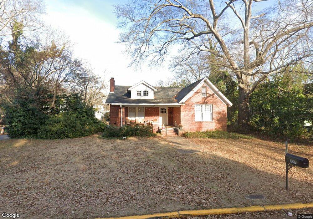
427 Bloomfield St Athens, GA 30605
Midtown-Bloomfield NeighborhoodEstimated Value: $538,000 - $779,000
Studio
--
Bath
1,237
Sq Ft
$529/Sq Ft
Est. Value
About This Home
This home is located at 427 Bloomfield St, Athens, GA 30605 and is currently estimated at $654,228, approximately $528 per square foot. 427 Bloomfield St is a home located in Clarke County with nearby schools including Barrow Elementary School, Clarke Middle School, and Clarke Central High School.
Ownership History
Date
Name
Owned For
Owner Type
Purchase Details
Closed on
Jan 11, 2002
Sold by
Smith R Riley
Bought by
Resent Llc
Current Estimated Value
Purchase Details
Closed on
Jan 8, 2001
Sold by
Smith Richard R and Riley Smit R
Bought by
Smith R Riley
Purchase Details
Closed on
Aug 26, 1996
Sold by
Haas Jeffrey D and Haas Kyle D
Bought by
Smith Richard R and Riley Smith R
Purchase Details
Closed on
Aug 16, 1991
Sold by
Ledvinka Kathleen Adamo
Bought by
Haas Jeffrey D and Haas Kyle D
Purchase Details
Closed on
Aug 10, 1989
Sold by
West E P Mrs
Bought by
Ledvinka Kathleen Adamo
Create a Home Valuation Report for This Property
The Home Valuation Report is an in-depth analysis detailing your home's value as well as a comparison with similar homes in the area
Home Values in the Area
Average Home Value in this Area
Purchase History
| Date | Buyer | Sale Price | Title Company |
|---|---|---|---|
| Resent Llc | -- | -- | |
| Smith R Riley | -- | -- | |
| Smith Richard R | $158,600 | -- | |
| Haas Jeffrey D | $115,000 | -- | |
| Ledvinka Kathleen Adamo | $78,000 | -- |
Source: Public Records
Tax History
| Year | Tax Paid | Tax Assessment Tax Assessment Total Assessment is a certain percentage of the fair market value that is determined by local assessors to be the total taxable value of land and additions on the property. | Land | Improvement |
|---|---|---|---|---|
| 2025 | $7,154 | $230,412 | $50,000 | $180,412 |
| 2024 | $7,154 | $205,256 | $40,000 | $165,256 |
| 2023 | $6,414 | $187,915 | $40,000 | $147,915 |
| 2022 | $5,239 | $164,244 | $40,000 | $124,244 |
| 2021 | $4,717 | $139,963 | $40,000 | $99,963 |
| 2020 | $4,386 | $130,162 | $40,000 | $90,162 |
| 2019 | $3,953 | $116,442 | $40,000 | $76,442 |
| 2018 | $3,670 | $108,112 | $40,000 | $68,112 |
| 2017 | $3,438 | $101,252 | $40,000 | $61,252 |
| 2016 | $3,288 | $96,841 | $40,000 | $56,841 |
| 2015 | $3,076 | $90,471 | $40,000 | $50,471 |
| 2014 | $2,981 | $87,559 | $34,000 | $53,559 |
Source: Public Records
Map
Nearby Homes
- 255 Bloomfield St
- 997 S Milledge Ave Unit 3
- 997 S Milledge Ave Unit 2
- 997 S Milledge Ave Unit 1
- 362 W Cloverhurst Ave
- 265 Springdale St
- 935 Baxter St Unit 3
- 1554 S Lumpkin St Unit 4
- 1554 S Lumpkin St Unit 6
- 1554 S Lumpkin St Unit 5
- 1554 S Lumpkin St Unit 1
- 1554 S Lumpkin St Unit 3
- 1554 S Lumpkin St Unit 7
- 1554 S Lumpkin St Unit 2
- 494 Baxter St Unit 22
- 230 Woodlawn Ave
- 170 Northview Dr Unit 5
- 338 Springdale St
- 303 S Church St
- 303 S Church St Unit 6
- 437 Bloomfield St
- 397 Bloomfield St Unit 3
- 397 Bloomfield St Unit 2
- 397 Bloomfield St
- 98 Springdale St
- 441 Bloomfield St
- 95 Springdale St
- 96 Springdale St
- 365 Bloomfield St
- 420 Bloomfield St
- 449 Bloomfield St
- 424 Bloomfield St
- 90 Springdale St
- 440 Bloomfield St
- 85 Springdale St Unit 85 Springdale Street
- 345 Bloomfield St
- 139 E Cloverhurst Ave
- 320 Bloomfield St
- 120.5 Cloverhurst Ave W
- 124 W Cloverhurst Ave
Your Personal Tour Guide
Ask me questions while you tour the home.