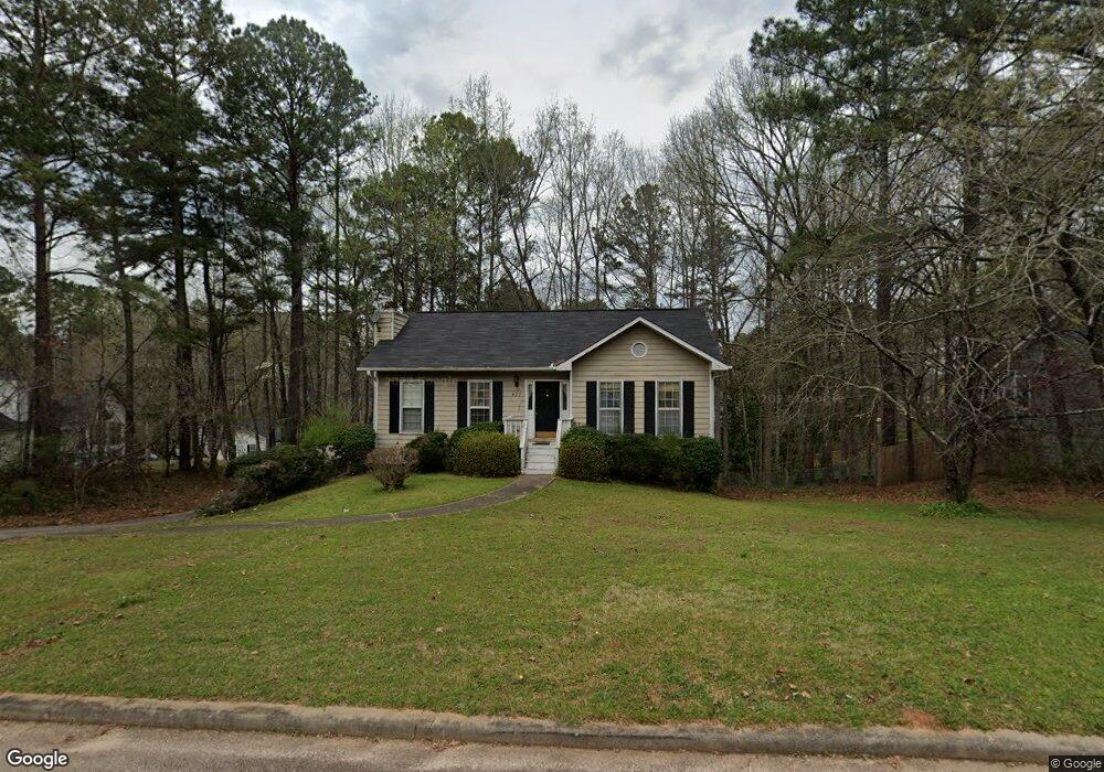
427 Brookstone Dr Lagrange, GA 30241
Estimated Value: $204,642 - $207,000
3
Beds
3
Baths
1,096
Sq Ft
$188/Sq Ft
Est. Value
About This Home
This home is located at 427 Brookstone Dr, Lagrange, GA 30241 and is currently estimated at $205,911, approximately $187 per square foot. 427 Brookstone Dr is a home located in Troup County with nearby schools including Callaway Elementary School, Hogansville Elementary School, and Callaway Middle School.
Ownership History
Date
Name
Owned For
Owner Type
Purchase Details
Closed on
Dec 20, 2022
Sold by
Poole Tyrone
Bought by
Poole Tyrone and Poole Rosemary
Current Estimated Value
Purchase Details
Closed on
Oct 21, 2021
Sold by
The Bachar Corporation Inc
Bought by
Poole Tyrone
Purchase Details
Closed on
Oct 10, 2012
Sold by
Poole Tyrone
Bought by
The Bacher Corporation M Inc
Purchase Details
Closed on
Aug 25, 1995
Sold by
James Bradfield
Bought by
Poole Tyrone
Purchase Details
Closed on
Jun 28, 1991
Sold by
C & S Real Estate Services Inc
Bought by
James Bradfield
Purchase Details
Closed on
Jun 19, 1991
Sold by
Dan Ric Inc
Bought by
C & S Real Estate Services Inc
Purchase Details
Closed on
Oct 25, 1990
Sold by
Jim B Wiles
Bought by
Dan Ric Inc
Purchase Details
Closed on
Oct 1, 1986
Bought by
Jim B Wiles
Create a Home Valuation Report for This Property
The Home Valuation Report is an in-depth analysis detailing your home's value as well as a comparison with similar homes in the area
Purchase History
| Date | Buyer | Sale Price | Title Company |
|---|---|---|---|
| Poole Tyrone | -- | -- | |
| Poole Tyrone | -- | -- | |
| The Bacher Corporation M Inc | -- | -- | |
| Poole Tyrone | $84,500 | -- | |
| James Bradfield | -- | -- | |
| C & S Real Estate Services Inc | $80,000 | -- | |
| Dan Ric Inc | $37,400 | -- | |
| Jim B Wiles | -- | -- |
Source: Public Records
Tax History
| Year | Tax Paid | Tax Assessment Tax Assessment Total Assessment is a certain percentage of the fair market value that is determined by local assessors to be the total taxable value of land and additions on the property. | Land | Improvement |
|---|---|---|---|---|
| 2025 | $1,825 | $76,280 | $14,000 | $62,280 |
| 2024 | $1,825 | $66,928 | $14,000 | $52,928 |
| 2023 | $1,742 | $63,888 | $14,000 | $49,888 |
| 2022 | $1,498 | $53,664 | $10,000 | $43,664 |
| 2021 | $1,356 | $44,972 | $8,000 | $36,972 |
| 2020 | $1,356 | $44,972 | $8,000 | $36,972 |
| 2019 | $1,251 | $41,464 | $8,000 | $33,464 |
| 2018 | $1,125 | $37,304 | $6,000 | $31,304 |
| 2017 | $1,125 | $37,304 | $6,000 | $31,304 |
| 2016 | $1,110 | $36,794 | $6,000 | $30,794 |
| 2015 | $1,116 | $36,929 | $6,000 | $30,929 |
| 2014 | $1,068 | $35,301 | $6,000 | $29,301 |
| 2013 | -- | $35,750 | $6,000 | $29,750 |
Source: Public Records
Map
Nearby Homes
- 105 Ridgefield Dr
- 124 Woodridge Cir
- 101 Sarah Ln
- 509 Youngs Mill Rd
- 227 River Meadow Dr Unit H14
- 227 River Meadow Dr
- 412 Sweetwood Ct Unit A36
- 304 Bridgette Blvd
- 793 Celebration Blvd
- 300 Old Pond Rd
- 119 Sir Lancelot St
- 107 N Barnard Ave
- 112 Celebration Blvd
- 0 N Barnard Ave
- 110 Lenox Cir
- 121 Ct
- 115 Clara Jean Ct
- 130 Clara Jean Ct
- 129 Celebration Blvd
- 5 Gulfstream Dr
- 302 Brookfield Dr
- 429 Brookstone Dr
- 306 Brookfield Dr
- 431 Brookstone Dr 0
- 431 Brookstone Drive 0
- 431 Brookstone Dr
- 428 Brookstone Dr
- 308 Brookfield Dr
- 303 Brookfield Dr
- 430 Brookstone Dr
- 426 Brookstone Dr
- 301 Brookfield Dr
- 305 Brookfield Dr
- 432 Brookstone Dr
- 307 Brookfield Dr
- 433 Brookstone Dr
- 324 Brookstone Dr
- 310 Brookfield Dr
- 219 Baileys Way Unit 67
- 221 Baileys Way
Your Personal Tour Guide
Ask me questions while you tour the home.