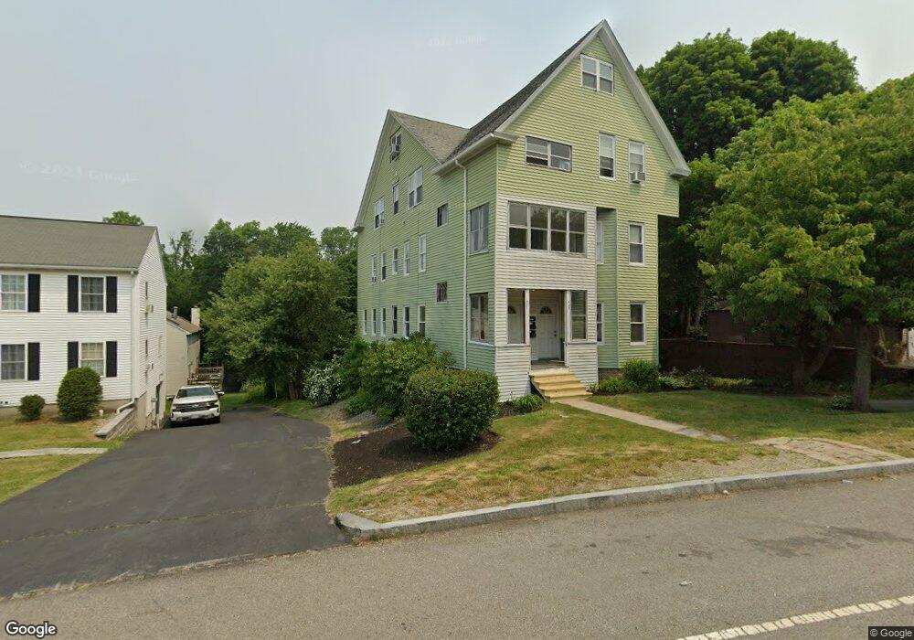
427 Hamilton St Worcester, MA 01604
Hamilton NeighborhoodEstimated Value: $661,000 - $770,000
7
Beds
3
Baths
3,890
Sq Ft
$186/Sq Ft
Est. Value
About This Home
This home is located at 427 Hamilton St, Worcester, MA 01604 and is currently estimated at $724,333, approximately $186 per square foot. 427 Hamilton St is a home located in Worcester County with nearby schools including Jacob Hiatt Magnet School, Chandler Magnet, and Lake View Elementary School.
Ownership History
Date
Name
Owned For
Owner Type
Purchase Details
Closed on
Jan 7, 1997
Sold by
Sullivan William F and Sullivan Kenneth
Bought by
Mitchell Daniel J
Current Estimated Value
Home Financials for this Owner
Home Financials are based on the most recent Mortgage that was taken out on this home.
Original Mortgage
$68,340
Interest Rate
7.48%
Mortgage Type
Purchase Money Mortgage
Create a Home Valuation Report for This Property
The Home Valuation Report is an in-depth analysis detailing your home's value as well as a comparison with similar homes in the area
Home Values in the Area
Average Home Value in this Area
Purchase History
| Date | Buyer | Sale Price | Title Company |
|---|---|---|---|
| Mitchell Daniel J | $70,000 | -- |
Source: Public Records
Mortgage History
| Date | Status | Borrower | Loan Amount |
|---|---|---|---|
| Open | Mitchell Daniel J | $161,000 | |
| Closed | Mitchell Daniel J | $16,148 | |
| Closed | Mitchell Daniel J | $68,340 |
Source: Public Records
Tax History Compared to Growth
Tax History
| Year | Tax Paid | Tax Assessment Tax Assessment Total Assessment is a certain percentage of the fair market value that is determined by local assessors to be the total taxable value of land and additions on the property. | Land | Improvement |
|---|---|---|---|---|
| 2025 | $8,997 | $682,100 | $119,000 | $563,100 |
| 2024 | $8,330 | $605,800 | $119,000 | $486,800 |
| 2023 | $7,962 | $555,200 | $103,400 | $451,800 |
| 2022 | $6,922 | $455,100 | $82,800 | $372,300 |
| 2021 | $6,370 | $391,300 | $66,200 | $325,100 |
| 2020 | $5,914 | $347,900 | $66,200 | $281,700 |
| 2019 | $5,920 | $328,900 | $59,700 | $269,200 |
| 2018 | $4,508 | $238,400 | $59,700 | $178,700 |
| 2017 | $4,259 | $221,600 | $59,700 | $161,900 |
| 2016 | $4,015 | $194,800 | $44,400 | $150,400 |
| 2015 | $3,910 | $194,800 | $44,400 | $150,400 |
| 2014 | $3,806 | $194,800 | $44,400 | $150,400 |
Source: Public Records
Map
Nearby Homes
- 4 Harold St
- 496 Hamilton St
- 21 Middlesex Ave Unit 102
- 15 Anderson Ave
- 340 Hamilton St
- 2 Touraine St
- 270 Coburn Ave
- 70 Harrington Way
- 119 Orton Street Extension
- 24 Benham St Unit B
- 79 Alvarado Ave
- 241 Lake Ave
- 42 Ancona Rd
- 11 Phoenix St
- 24 Sherbrook Ave
- 22 Sherbrook Ave
- 80 Delmont Ave
- 47 Alvarado Ave Unit 1A
- 68 Dartmouth St
- 61 Progressive St
- 427 Hamilton St Unit FURNISHED unit 2
- 423 Hamilton St
- 431 Hamilton St
- 421 Hamilton St
- 2 Ralph Ave
- 435 Hamilton St
- 4 Ralph Ave
- 417 Hamilton St Unit 419
- 428 Hamilton St
- 420 Hamilton St
- 416 Hamilton St
- 6 Ralph Ave
- 437 Hamilton St Unit F
- 437 Hamilton St Unit E
- 437 Hamilton St Unit D
- 437 Hamilton St Unit C
- 437 Hamilton St Unit B
- 437 Hamilton St Unit A
- 439 Hamilton St
- 434 Hamilton St