Estimated Value: $257,000 - $275,000
3
Beds
1
Bath
1,597
Sq Ft
$167/Sq Ft
Est. Value
About This Home
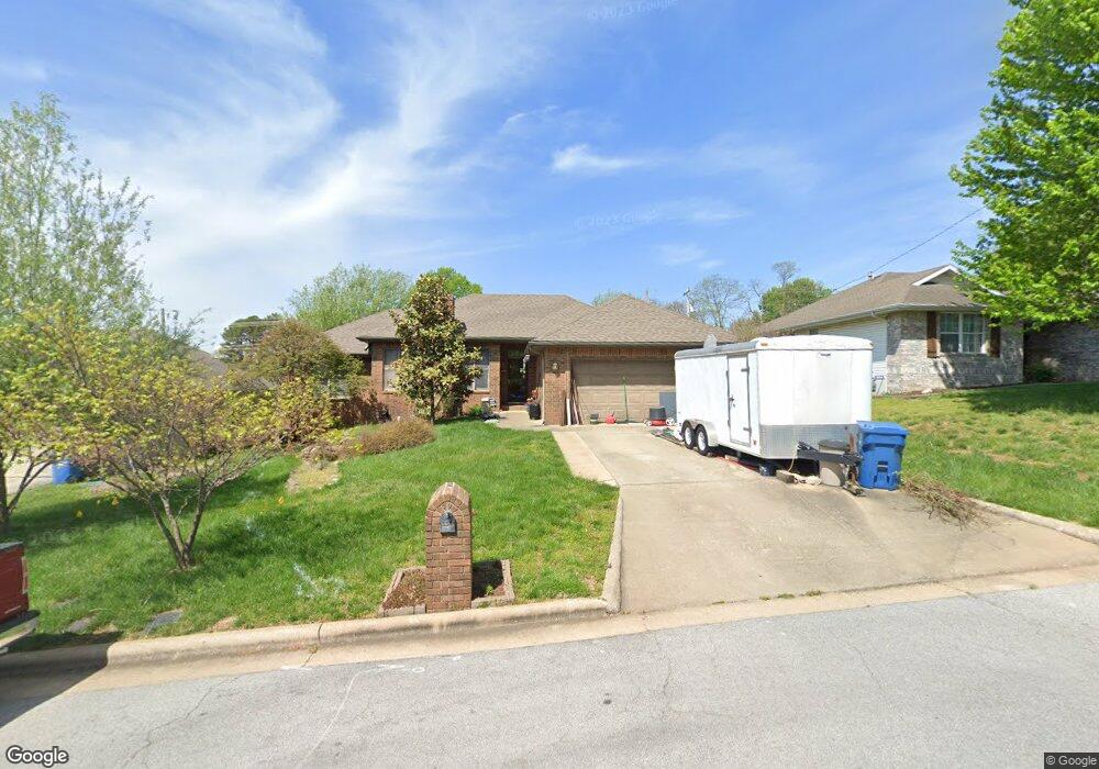
This home is located at 427 S Devonshire St, Nixa, MO 65714 and is currently estimated at $266,297, approximately $166 per square foot. 427 S Devonshire St is a home with nearby schools including Summit Intermediate School, High Pointe Elementary School, and Nixa Junior High School.
Ownership History
Date
Name
Owned For
Owner Type
Purchase Details
Closed on
Dec 14, 2022
Sold by
Kessler David
Bought by
Mark M Tendai Iii Irrevocable Spendthrift Tru
Current Estimated Value
Purchase Details
Closed on
May 27, 2005
Sold by
Reynolds Jeff and Reynolds Misty
Bought by
Biggers James D and Biggers Lillian K
Home Financials for this Owner
Home Financials are based on the most recent Mortgage that was taken out on this home.
Original Mortgage
$93,500
Interest Rate
6.5%
Mortgage Type
Adjustable Rate Mortgage/ARM
Create a Home Valuation Report for This Property
The Home Valuation Report is an in-depth analysis detailing your home's value as well as a comparison with similar homes in the area
Home Values in the Area
Average Home Value in this Area
Purchase History
| Date | Buyer | Sale Price | Title Company |
|---|---|---|---|
| Mark M Tendai Iii Irrevocable Spendthrift Tru | -- | -- | |
| Mark M Tendai Iii Irrevocable Spendthrift Tru | -- | -- | |
| Biggers James D | -- | None Available |
Source: Public Records
Mortgage History
| Date | Status | Borrower | Loan Amount |
|---|---|---|---|
| Previous Owner | Biggers James D | $93,500 |
Source: Public Records
Tax History
| Year | Tax Paid | Tax Assessment Tax Assessment Total Assessment is a certain percentage of the fair market value that is determined by local assessors to be the total taxable value of land and additions on the property. | Land | Improvement |
|---|---|---|---|---|
| 2025 | $1,706 | $29,070 | -- | -- |
| 2024 | $1,706 | $27,380 | -- | -- |
| 2023 | $1,706 | $27,380 | $0 | $0 |
| 2022 | $1,548 | $24,810 | $0 | $0 |
| 2021 | $1,549 | $24,810 | $0 | $0 |
| 2020 | $1,380 | $21,090 | $0 | $0 |
| 2019 | $1,380 | $21,090 | $0 | $0 |
| 2018 | $1,285 | $21,090 | $0 | $0 |
| 2017 | $1,285 | $21,090 | $0 | $0 |
| 2016 | $1,179 | $19,650 | $0 | $0 |
| 2015 | $1,181 | $19,650 | $19,650 | $0 |
| 2014 | $1,156 | $19,720 | $0 | $0 |
| 2013 | $11 | $19,720 | $0 | $0 |
| 2011 | $11 | $36,680 | $0 | $0 |
Source: Public Records
Map
Nearby Homes
- 427 S Main St
- 425 S Devonshire St
- 104 Willow Ln
- 105 W Twin Oak Dr
- 316 S Market St
- 117 W Trail Point Dr
- 573 Barn Stable
- 404 E Elm St
- Sw Corner Highway 160 & St S
- 577 S Canterbury Ln
- 209&211 E Mount Vernon St
- 821 S Barberry Ct
- 104 Missouri Ave
- 601 Carriage Crossing
- 000 West St
- 108 W Walnut St
- 000 Croley Blvd Unit Lots 12,13, 14
- 307 N Prospect St
- 308 N Prospect St
- 000 (Tbd) Highway 160 (14 8 Acres) St
- 425 Devonshire St
- 429 S Devonshire St
- 423 S Devonshire St
- 428 Devonshire St
- 426 S Devonshire St
- 428 S Devonshire St
- 423 S Main St
- 421 Devonshire St
- 433 Devonshire St
- 105 E Newcastle Ct
- 421 S Main St
- 106 E Newcastle Ct
- 419 S Devonshire St
- 102 Yorkshire St
- 107 Yorkshire St
- 425 1/2 S Main St
- 420 S Devonshire St
- 425 1/2 S Main South St
- 104 E Yorkshire St
- 419 S Main St
Your Personal Tour Guide
Ask me questions while you tour the home.