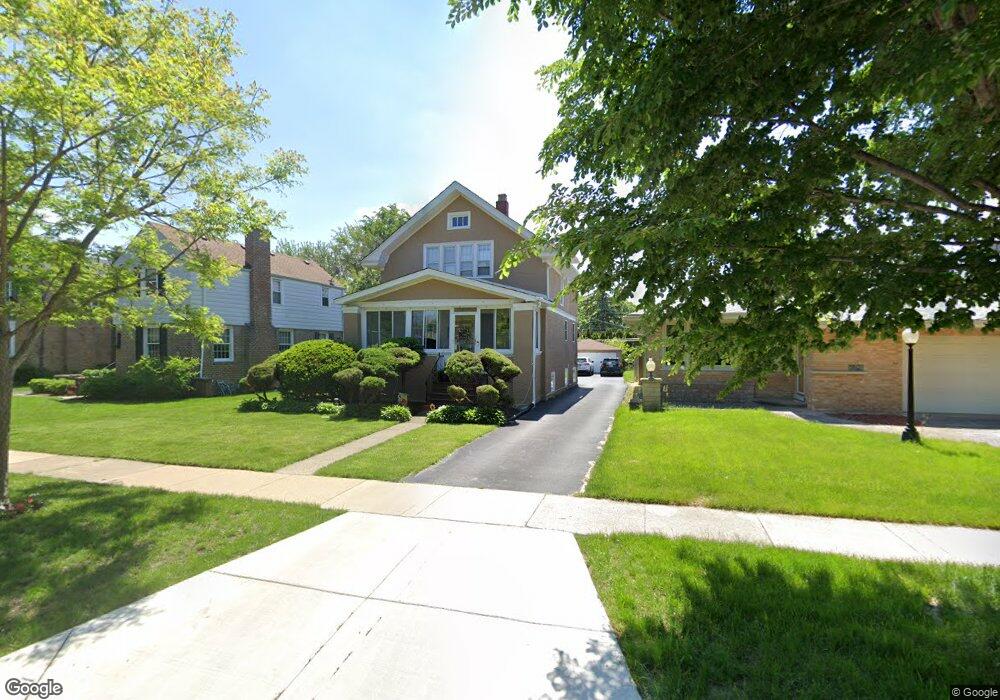
427 Shenstone Rd Riverside, IL 60546
Estimated Value: $413,000 - $574,000
About This Home
This home is located at 427 Shenstone Rd, Riverside, IL 60546 and is currently estimated at $503,628, approximately $313 per square foot. 427 Shenstone Rd is a home located in Cook County with nearby schools including Blythe Park Elementary School, L J Hauser Jr High School, and Riverside Brookfield High School.
Ownership History
We collect this data history from publicly available records. To have your information removed, we recommend requesting removal directly through your county’s website.
Purchase Details
Home Financials for this Owner
Home Financials are based on the most recent Mortgage that was taken out on this home.Home Values in the Area
Average Home Value in this Area
Purchase History
We collect this data history from publicly available records. To have your information removed, we recommend requesting removal directly through your county’s website.
| Date | Buyer | Sale Price | Title Company |
|---|---|---|---|
| $260,500 | -- |
Mortgage History
We collect this data history from publicly available records. To have your information removed, we recommend requesting removal directly through your county’s website.
| Date | Status | Borrower | Loan Amount |
|---|---|---|---|
| Closed | $247,000 |
Tax History
We collect this data history from publicly available records. To have your information removed, we recommend requesting removal directly through your county’s website.
| Year | Tax Paid | Tax Assessment Tax Assessment Total Assessment is a certain percentage of the fair market value that is determined by local assessors to be the total taxable value of land and additions on the property. | Land | Improvement |
|---|---|---|---|---|
| 2025 | $11,096 | $38,000 | $7,932 | $30,068 |
| 2024 | $11,096 | $38,000 | $7,932 | $30,068 |
| 2023 | $11,860 | $38,000 | $7,932 | $30,068 |
| 2022 | $11,860 | $34,385 | $6,941 | $27,444 |
| 2021 | $11,429 | $34,384 | $6,940 | $27,444 |
| 2020 | $11,793 | $36,230 | $6,940 | $29,290 |
| 2019 | $10,228 | $32,490 | $6,345 | $26,145 |
| 2018 | $9,926 | $32,490 | $6,345 | $26,145 |
| 2017 | $9,624 | $32,490 | $6,345 | $26,145 |
| 2016 | $9,377 | $29,124 | $5,552 | $23,572 |
| 2015 | $9,119 | $29,124 | $5,552 | $23,572 |
| 2014 | $8,981 | $29,124 | $5,552 | $23,572 |
| 2013 | $8,298 | $29,227 | $5,552 | $23,675 |
Map
- 389 Addison Rd
- 475 Shenstone Rd Unit 304
- 731 Selborne Rd
- 3032 Wisconsin Ave
- 342 Lawton Rd
- 3224 Home Ave
- 3100 Clinton Ave
- 7023 29th Place
- 6901 31st St
- 2841 Wenonah Ave
- 234 Southcote Rd
- 461 Uvedale Rd
- 317 Olmsted Rd
- 6840 30th St
- 3546 Wenonah Ave
- 3424 Kenilworth Ave
- 3303 Grove Ave Unit 306
- 7047 26th Pkwy
- 3548 Clinton Ave
- 377 Blackhawk Rd
- 408 Addison Rd
- 404 Addison Rd
- 410 Addison Rd
- 400 Addison Rd
- 412 Addison Rd
- 398 Addison Rd
- 424 Addison Rd
- 439 Shenstone Rd
- 435 Shenstone Rd
- 443 Shenstone Rd
- 429 Shenstone Rd
- 396 Addison Rd
- 447 Shenstone Rd
- 428 Addison Rd
- 451 Shenstone Rd
- 409 Addison Rd
- 413 Addison Rd
- 405 Addison Rd
- 425 Shenstone Rd
- 417 Addison Rd
Ask me questions while you tour the home.