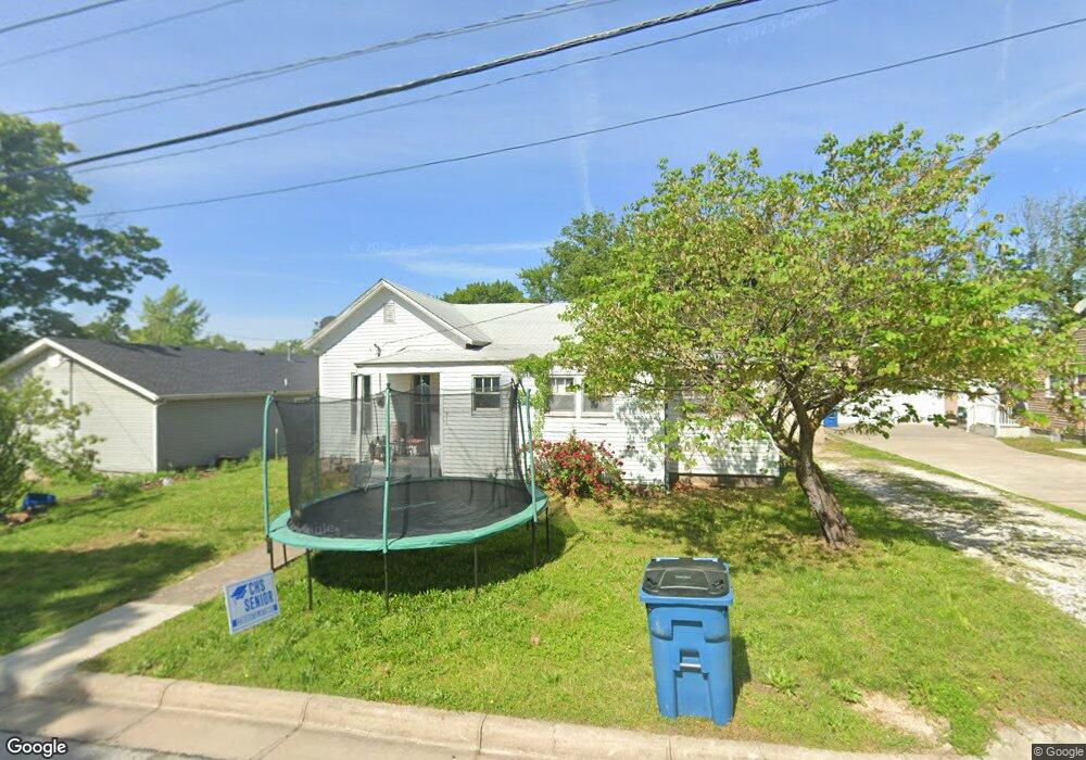
427 Sophia St Carthage, MO 64836
Estimated Value: $70,384 - $114,000
2
Beds
1
Bath
829
Sq Ft
$114/Sq Ft
Est. Value
About This Home
This home is located at 427 Sophia St, Carthage, MO 64836 and is currently estimated at $94,846, approximately $114 per square foot. 427 Sophia St is a home located in Jasper County with nearby schools including Victory Academy and St. Ann's Catholic School.
Ownership History
Date
Name
Owned For
Owner Type
Purchase Details
Closed on
Jan 13, 2017
Sold by
Gutierrez Thelma Araceli and Valladares Edwin
Bought by
Gutierrez Glenda F Barrios
Current Estimated Value
Purchase Details
Closed on
Jan 29, 2014
Sold by
Southwest Missouri Bank
Bought by
Gutlerrez Thelma Aracely
Purchase Details
Closed on
May 1, 2013
Sold by
Brown Denzil L and Brown Virginia L
Bought by
Southwest Missouri Bank
Purchase Details
Closed on
Aug 4, 2005
Sold by
Mazariegos Gloria Marina
Bought by
Brown Denzil L and Brown Virginia L
Create a Home Valuation Report for This Property
The Home Valuation Report is an in-depth analysis detailing your home's value as well as a comparison with similar homes in the area
Home Values in the Area
Average Home Value in this Area
Purchase History
| Date | Buyer | Sale Price | Title Company |
|---|---|---|---|
| Gutierrez Glenda F Barrios | -- | None Available | |
| Gutlerrez Thelma Aracely | -- | None Available | |
| Southwest Missouri Bank | $20,000 | None Available | |
| Brown Denzil L | -- | -- |
Source: Public Records
Tax History Compared to Growth
Tax History
| Year | Tax Paid | Tax Assessment Tax Assessment Total Assessment is a certain percentage of the fair market value that is determined by local assessors to be the total taxable value of land and additions on the property. | Land | Improvement |
|---|---|---|---|---|
| 2025 | $358 | $7,840 | $930 | $6,910 |
| 2024 | $358 | $6,960 | $930 | $6,030 |
| 2023 | $358 | $6,960 | $930 | $6,030 |
| 2022 | $350 | $6,820 | $930 | $5,890 |
| 2021 | $346 | $6,820 | $930 | $5,890 |
| 2020 | $256 | $4,840 | $930 | $3,910 |
| 2019 | $257 | $4,840 | $930 | $3,910 |
| 2018 | $256 | $4,840 | $0 | $0 |
| 2017 | $257 | $4,840 | $0 | $0 |
| 2016 | $256 | $4,840 | $0 | $0 |
| 2015 | $237 | $4,840 | $0 | $0 |
| 2014 | $237 | $4,840 | $0 | $0 |
Source: Public Records
Map
Nearby Homes
- 1014 Sycamore St
- 1210 Walnut St
- 703 W Central Tract 2
- 527 Olive St
- 1015 Cedar St
- 424 Walnut St
- 1324 W Central Ave
- 903 S Main St
- 510 Miller St
- 1121 Ash St
- 300 N Maple St
- 514 W Macon St
- 1112 S Garrison Ave
- 1131 Lyon St
- 1014 S Main St
- 1160 S Maple St
- 1007 Grant St
- 1302 Robertson Ave
- 112 E 11th St
- 1422 W Macon St