Estimated Value: $226,000 - $258,798
3
Beds
3
Baths
1,904
Sq Ft
$128/Sq Ft
Est. Value
About This Home
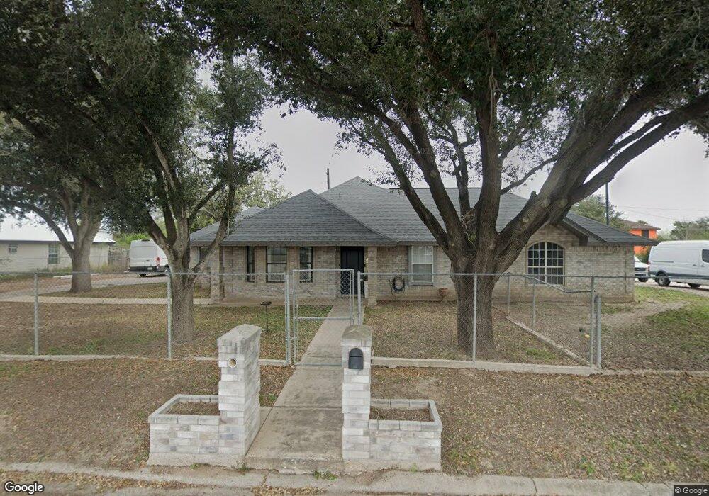
This home is located at 427 W Buchanan Ave Unit 66-68, Alton, TX 78573 and is currently estimated at $244,200, approximately $128 per square foot. 427 W Buchanan Ave Unit 66-68 is a home located in Hidalgo County with nearby schools including Cantu Elementary School, Alton Memorial Junior High School, and Mission High School.
Ownership History
Date
Name
Owned For
Owner Type
Purchase Details
Closed on
Jun 7, 2011
Sold by
Medley Monty
Bought by
Deutsche Bank National Trust Company
Current Estimated Value
Purchase Details
Closed on
Jul 20, 2006
Sold by
Indalecio Arturo and Indalecio Maribel
Bought by
Martinez Heriberto G and Lopez San Juanita G
Home Financials for this Owner
Home Financials are based on the most recent Mortgage that was taken out on this home.
Original Mortgage
$89,250
Interest Rate
6.6%
Mortgage Type
New Conventional
Create a Home Valuation Report for This Property
The Home Valuation Report is an in-depth analysis detailing your home's value as well as a comparison with similar homes in the area
Home Values in the Area
Average Home Value in this Area
Purchase History
| Date | Buyer | Sale Price | Title Company |
|---|---|---|---|
| Deutsche Bank National Trust Company | $75,000 | None Available | |
| Martinez Heriberto G | -- | Charge San Jacinto Title Ser |
Source: Public Records
Mortgage History
| Date | Status | Borrower | Loan Amount |
|---|---|---|---|
| Previous Owner | Martinez Heriberto G | $89,250 |
Source: Public Records
Tax History Compared to Growth
Tax History
| Year | Tax Paid | Tax Assessment Tax Assessment Total Assessment is a certain percentage of the fair market value that is determined by local assessors to be the total taxable value of land and additions on the property. | Land | Improvement |
|---|---|---|---|---|
| 2025 | $3,731 | $217,735 | -- | -- |
| 2024 | $3,731 | $197,941 | -- | -- |
| 2023 | $4,398 | $179,946 | $0 | $0 |
| 2022 | $4,013 | $163,587 | $0 | $0 |
| 2021 | $3,706 | $148,715 | $44,550 | $104,165 |
| 2020 | $3,653 | $141,271 | $44,550 | $96,721 |
| 2019 | $3,467 | $129,072 | $44,550 | $89,813 |
| 2018 | $3,172 | $117,338 | $32,400 | $84,938 |
| 2017 | $3,199 | $117,338 | $32,400 | $84,938 |
| 2016 | $3,485 | $127,822 | $32,400 | $95,422 |
| 2015 | $3,011 | $127,495 | $32,400 | $95,095 |
Source: Public Records
Map
Nearby Homes
- 503 W Adams Ave
- 429 W Adams Ave
- 413 W Adams Ave
- 211 S Delaware St
- 0000 N Trosper Rd
- 912 W Kohala Ave
- 1009 W Kohala Ave
- 000 Mile 5 Dr
- 1421 W Dawes Ave
- 616 Eisenhower Ave
- 00081 Franklin Ave
- 1010 W Dukakis Ave
- 1104 W Dukakis Ave
- 00 Conway
- 211 W Campeche Ave
- 617 W Garfield Ave
- 1105 W Eisenhower Ave
- 311 W Campeche Ave
- 616 W Diamondhead Ave
- 207 W Campeche Ave
- 427 W Buchanan Ave
- 427 W Buchanan Ave
- 509 W Buchanan Ave
- 423 W Buchanan Ave
- 513 W Buchanan Ave
- 516 W Buchanan Ave
- 506 W Buchanan Ave
- 502 W Buchanan Ave
- 419 W Buchanan Ave
- 418 W Andrews St
- 422 W Andrews St
- 512 W Andrews St
- 424 W Buchanan Ave
- 420 W Buchanan Ave
- 516 W Andrew Ave
- 415 W Buchanan Ave
- 416 W Buchanan Ave
- 521 W Buchanan Ave
- 522 W Buchanan Ave
- 411 W Buchanan Ave