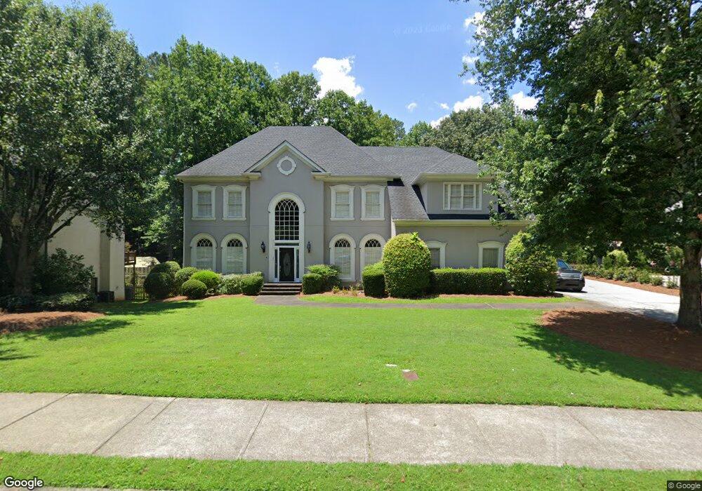
4270 River Bottom Dr Unit IX Norcross, GA 30092
Estimated Value: $872,000 - $1,081,000
4
Beds
3
Baths
3,887
Sq Ft
$245/Sq Ft
Est. Value
About This Home
This home is located at 4270 River Bottom Dr Unit IX, Norcross, GA 30092 and is currently estimated at $952,408, approximately $245 per square foot. 4270 River Bottom Dr Unit IX is a home located in Gwinnett County with nearby schools including Simpson Elementary School, Pinckneyville Middle School, and Norcross High School.
Ownership History
Date
Name
Owned For
Owner Type
Purchase Details
Closed on
May 23, 2001
Sold by
Taylor Roberta
Bought by
Taylor Roberta and Taylor Catherine A
Current Estimated Value
Home Financials for this Owner
Home Financials are based on the most recent Mortgage that was taken out on this home.
Original Mortgage
$396,000
Outstanding Balance
$147,611
Interest Rate
7.17%
Mortgage Type
New Conventional
Estimated Equity
$804,797
Purchase Details
Closed on
Apr 13, 1993
Sold by
Brown Webb Bldrs
Bought by
Cole Robert S Lori
Home Financials for this Owner
Home Financials are based on the most recent Mortgage that was taken out on this home.
Original Mortgage
$324,550
Interest Rate
7.47%
Create a Home Valuation Report for This Property
The Home Valuation Report is an in-depth analysis detailing your home's value as well as a comparison with similar homes in the area
Home Values in the Area
Average Home Value in this Area
Purchase History
| Date | Buyer | Sale Price | Title Company |
|---|---|---|---|
| Taylor Roberta | -- | -- | |
| Taylor Roberta | $440,000 | -- | |
| Cole Robert S Lori | $432,800 | -- |
Source: Public Records
Mortgage History
| Date | Status | Borrower | Loan Amount |
|---|---|---|---|
| Open | Taylor Roberta | $396,000 | |
| Previous Owner | Cole Robert S Lori | $324,550 |
Source: Public Records
Tax History Compared to Growth
Tax History
| Year | Tax Paid | Tax Assessment Tax Assessment Total Assessment is a certain percentage of the fair market value that is determined by local assessors to be the total taxable value of land and additions on the property. | Land | Improvement |
|---|---|---|---|---|
| 2025 | $3,200 | $398,560 | $61,960 | $336,600 |
| 2024 | $3,175 | $378,200 | $71,200 | $307,000 |
| 2023 | $3,175 | $315,480 | $64,000 | $251,480 |
| 2022 | $3,164 | $276,520 | $52,000 | $224,520 |
| 2021 | $3,159 | $256,400 | $49,840 | $206,560 |
| 2020 | $3,154 | $256,400 | $49,840 | $206,560 |
| 2019 | $2,875 | $237,120 | $44,000 | $193,120 |
| 2018 | $2,870 | $220,600 | $36,000 | $184,600 |
| 2016 | $7,222 | $206,200 | $36,000 | $170,200 |
| 2015 | $7,311 | $206,200 | $36,000 | $170,200 |
| 2014 | $7,237 | $206,200 | $36,000 | $170,200 |
Source: Public Records
Map
Nearby Homes
- 4291 River Bottom Dr
- 4405 River Trail Dr
- 4410 River Trail Dr Unit 383
- 4575 Dairy Way
- 6040 Neely Farm Dr Unit 3
- 0 Hawk Run Unit 7571401
- 0 Hawk Run
- 6169 Poplar Bluff Cir
- 5970 Rachel Ridge Unit 2
- 8103 Lawnview
- 5961 Ranger Ct
- 3156 E Addison Dr
- 6425 Deerings Ln Unit 6425
- 6433 Deerings Ln
- 6501 Deerings Ln Unit 6501
- 6538 Deerings Ln
- 6307 Deerings Hollow
- 7315 Chattahoochee Bluff Dr
- 6530 Deerings Ln
- 4260 River Bottom Dr Unit IX
- 4280 River Bottom Dr
- 4271 River Bottom Dr
- 4250 River Bottom Dr Unit 1
- 6311 Indian River Dr
- 4290 River Bottom Dr Unit 5
- 4281 River Bottom Dr
- 4329 Old Bridge Ln
- 4319 Old Bridge Ln
- 4309 Old Bridge Ln
- 4240 River Bottom Dr
- 4299 Old Bridge Ln
- 6291 Indian River Dr
- 6310 Indian River Dr Unit IX
- 4300 River Bottom Dr
- 4289 Old Bridge Ln
- 4339 Old Bridge Ln
- 4230 River Bottom Dr
- 6270 Blackberry Hill Unit 15
- 6270 Blackberry Hill