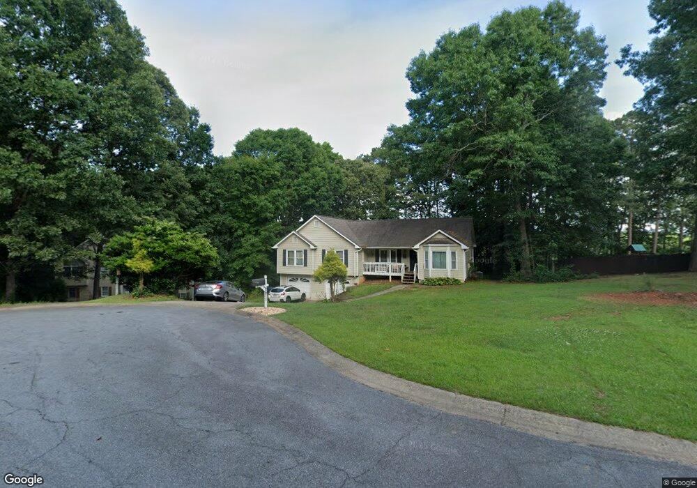
4271 Sherry Ln Canton, GA 30114
Estimated Value: $404,000 - $426,189
4
Beds
2
Baths
2,095
Sq Ft
$199/Sq Ft
Est. Value
About This Home
This home is located at 4271 Sherry Ln, Canton, GA 30114 and is currently estimated at $416,047, approximately $198 per square foot. 4271 Sherry Ln is a home located in Cherokee County with nearby schools including Sixes Elementary School, Freedom Middle School, and Woodstock High School.
Ownership History
Date
Name
Owned For
Owner Type
Purchase Details
Closed on
Jul 18, 2012
Sold by
Lauman Joseph
Bought by
Lauman Jennifer
Current Estimated Value
Purchase Details
Closed on
Aug 30, 2006
Sold by
Dobbins Robert E and Dobbins Pamela T
Bought by
Lauman Joseph J and Lauman Jennifer L
Home Financials for this Owner
Home Financials are based on the most recent Mortgage that was taken out on this home.
Original Mortgage
$147,920
Interest Rate
10.5%
Purchase Details
Closed on
Jun 24, 1993
Sold by
Roach Robert
Bought by
Dobbins Robert E and Dobbins Pamela T
Home Financials for this Owner
Home Financials are based on the most recent Mortgage that was taken out on this home.
Original Mortgage
$98,300
Interest Rate
7.52%
Create a Home Valuation Report for This Property
The Home Valuation Report is an in-depth analysis detailing your home's value as well as a comparison with similar homes in the area
Home Values in the Area
Average Home Value in this Area
Purchase History
| Date | Buyer | Sale Price | Title Company |
|---|---|---|---|
| Lauman Jennifer | $184,900 | -- | |
| Lauman Joseph J | $184,900 | -- | |
| Dobbins Robert E | $103,500 | -- |
Source: Public Records
Mortgage History
| Date | Status | Borrower | Loan Amount |
|---|---|---|---|
| Previous Owner | Lauman Joseph J | $147,920 | |
| Previous Owner | Dobbins Robert E | $98,300 |
Source: Public Records
Tax History
| Year | Tax Paid | Tax Assessment Tax Assessment Total Assessment is a certain percentage of the fair market value that is determined by local assessors to be the total taxable value of land and additions on the property. | Land | Improvement |
|---|---|---|---|---|
| 2025 | $4,449 | $169,412 | $24,000 | $145,412 |
| 2024 | $4,075 | $156,808 | $24,000 | $132,808 |
| 2023 | $4,147 | $159,568 | $24,000 | $135,568 |
| 2022 | $3,298 | $125,488 | $24,000 | $101,488 |
| 2021 | $3,006 | $105,884 | $17,600 | $88,284 |
| 2020 | $2,736 | $96,284 | $17,600 | $78,684 |
| 2019 | $2,665 | $93,800 | $16,800 | $77,000 |
| 2018 | $2,439 | $85,320 | $15,200 | $70,120 |
| 2017 | $2,190 | $190,000 | $14,000 | $62,000 |
| 2016 | $2,046 | $175,700 | $14,000 | $56,280 |
| 2015 | $1,903 | $161,800 | $14,000 | $50,720 |
| 2014 | $1,733 | $147,100 | $14,000 | $44,840 |
Source: Public Records
Map
Nearby Homes
- 3161 Marble Quarry Rd
- 1302 Sixes Rd
- 1415 Sixes Rd
- 151 Wentworth Dr
- 412 Fernstone Dr
- 319 Hillgrove Dr
- 2550 Mountain Brook Rd
- 520 Andes Ln
- 1600 Mountain Trace
- 415 Crestmont Ln
- 417 Crestmont Ln
- 376 Whitetail Cir
- 276 Whitetail Cir
- 1600 Sixes Rd
- 206 Sawtooth Ct
- 208 Sawtooth Ct
- 408 Candy Ln
- 246 Manous Way
- 1243 Palm Ridge Trace
- 1418 Palm St
Your Personal Tour Guide
Ask me questions while you tour the home.