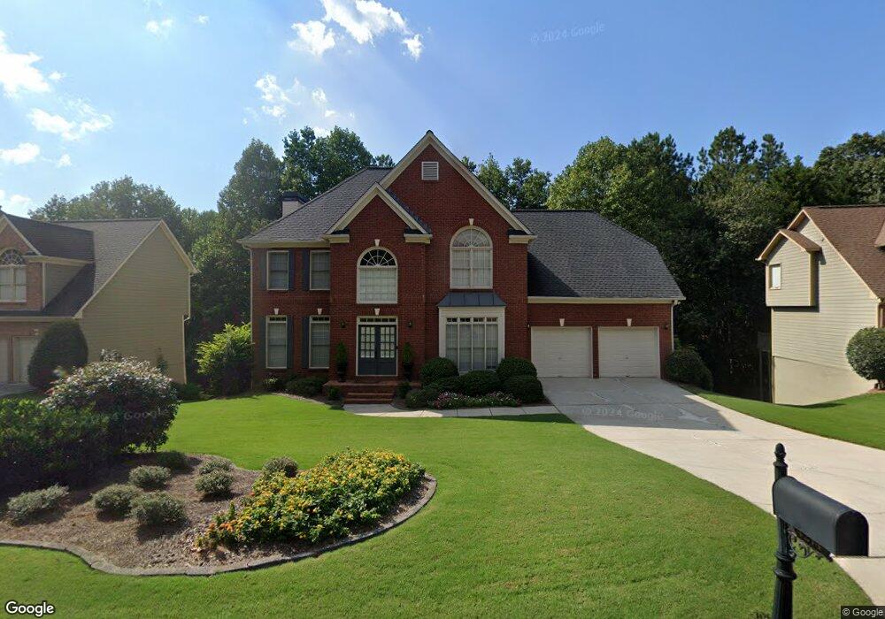
4274 Silver Peak Pkwy Unit 1 Suwanee, GA 30024
Estimated Value: $631,242 - $693,000
4
Beds
3
Baths
3,048
Sq Ft
$215/Sq Ft
Est. Value
About This Home
This home is located at 4274 Silver Peak Pkwy Unit 1, Suwanee, GA 30024 and is currently estimated at $655,311, approximately $214 per square foot. 4274 Silver Peak Pkwy Unit 1 is a home located in Gwinnett County with nearby schools including Level Creek Elementary School, North Gwinnett Middle School, and North Gwinnett High School.
Ownership History
Date
Name
Owned For
Owner Type
Purchase Details
Closed on
Aug 29, 2001
Sold by
Schofield Brent R
Bought by
Schofield Brent R and Schofield Melissa K
Current Estimated Value
Home Financials for this Owner
Home Financials are based on the most recent Mortgage that was taken out on this home.
Original Mortgage
$194,400
Outstanding Balance
$74,263
Interest Rate
7.02%
Mortgage Type
New Conventional
Estimated Equity
$581,048
Purchase Details
Closed on
May 22, 1998
Sold by
Sharp Development Inc
Bought by
Eddings Otis L and Eddings Linda J
Home Financials for this Owner
Home Financials are based on the most recent Mortgage that was taken out on this home.
Original Mortgage
$168,800
Interest Rate
7.15%
Mortgage Type
New Conventional
Create a Home Valuation Report for This Property
The Home Valuation Report is an in-depth analysis detailing your home's value as well as a comparison with similar homes in the area
Home Values in the Area
Average Home Value in this Area
Purchase History
| Date | Buyer | Sale Price | Title Company |
|---|---|---|---|
| Schofield Brent R | -- | -- | |
| Schofield Brent R | $243,000 | -- | |
| Eddings Otis L | $211,000 | -- |
Source: Public Records
Mortgage History
| Date | Status | Borrower | Loan Amount |
|---|---|---|---|
| Open | Schofield Brent R | $194,400 | |
| Previous Owner | Eddings Otis L | $168,800 |
Source: Public Records
Tax History Compared to Growth
Tax History
| Year | Tax Paid | Tax Assessment Tax Assessment Total Assessment is a certain percentage of the fair market value that is determined by local assessors to be the total taxable value of land and additions on the property. | Land | Improvement |
|---|---|---|---|---|
| 2025 | $5,999 | $261,680 | $44,080 | $217,600 |
| 2024 | $5,431 | $225,360 | $39,200 | $186,160 |
| 2023 | $5,431 | $225,360 | $39,200 | $186,160 |
| 2022 | $5,037 | $205,200 | $39,200 | $166,000 |
| 2021 | $4,185 | $158,680 | $29,440 | $129,240 |
| 2020 | $4,706 | $147,320 | $29,440 | $117,880 |
| 2019 | $3,856 | $141,920 | $35,600 | $106,320 |
| 2018 | $3,876 | $141,920 | $35,600 | $106,320 |
| 2016 | $3,599 | $128,960 | $32,400 | $96,560 |
| 2015 | $3,308 | $114,000 | $27,000 | $87,000 |
| 2014 | $3,327 | $114,000 | $27,000 | $87,000 |
Source: Public Records
Map
Nearby Homes
- 837 Village Manor Place
- 1350 Peachtree Industrial Blvd
- 858 Red Rock Ct
- 4282 Goldfield Trace Unit 4
- 4544 Silver Peak Pkwy
- 4339 Lansfaire Terrace Unit 4
- 780 Village Field Ct
- 655 Grove Manor Ct
- 1116 Bartlett Trace
- 4335 Landover Way Unit 3
- 4416 Village Field Place
- 645 Stonepark Ln
- 1621 Wellborn Walk
- 671 Village Field Ct
- 4422 Grove Field Park
- 4265 Lansmoore Crossing
- 755 Amberton Close Unit 2
- 4264 Silver Peak Pkwy
- 4284 Silver Peak Pkwy
- 4254 Silver Peak Pkwy
- 740 Yosemite Dr
- 4279 Silver Peak Pkwy
- 4289 Silver Peak Pkwy
- 0 Silver Peak Pkwy Unit 8624198
- 0 Silver Peak Pkwy Unit 8614046
- 0 Silver Peak Pkwy Unit 7209854
- 0 Silver Peak Pkwy Unit 8726047
- 0 Silver Peak Pkwy Unit 8707568
- 0 Silver Peak Pkwy Unit 8609254
- 0 Silver Peak Pkwy Unit 8661035
- 0 Silver Peak Pkwy Unit 7157304
- 0 Silver Peak Pkwy Unit 8841132
- 0 Silver Peak Pkwy Unit 3156410
- 0 Silver Peak Pkwy Unit 7237220
- 0 Silver Peak Pkwy Unit 7254903
- 0 Silver Peak Pkwy Unit 8086160
- 0 Silver Peak Pkwy Unit 8174091