Estimated Value: $255,000 - $295,000
4
Beds
2
Baths
1,608
Sq Ft
$175/Sq Ft
Est. Value
About This Home
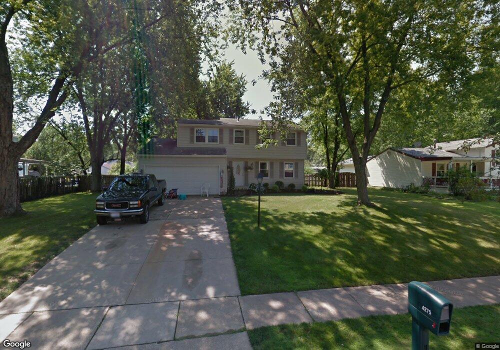
This home is located at 4275 Hile Rd, Stow, OH 44224 and is currently estimated at $280,919, approximately $174 per square foot. 4275 Hile Rd is a home located in Summit County with nearby schools including Stow-Munroe Falls High School, Holy Family Elementary School, and Walsh Jesuit High School.
Ownership History
Date
Name
Owned For
Owner Type
Purchase Details
Closed on
Dec 6, 2024
Sold by
Oconnor Jason P and Oconnor Jillian
Bought by
Oconnor Jason P and Oconnor Jillian
Current Estimated Value
Home Financials for this Owner
Home Financials are based on the most recent Mortgage that was taken out on this home.
Original Mortgage
$131,000
Outstanding Balance
$129,956
Interest Rate
6.72%
Mortgage Type
New Conventional
Estimated Equity
$150,963
Purchase Details
Closed on
May 21, 2007
Sold by
Shank Mark T and Shank Koral Kinsley
Bought by
Oconnor Jason P
Home Financials for this Owner
Home Financials are based on the most recent Mortgage that was taken out on this home.
Original Mortgage
$112,800
Interest Rate
6%
Mortgage Type
Purchase Money Mortgage
Create a Home Valuation Report for This Property
The Home Valuation Report is an in-depth analysis detailing your home's value as well as a comparison with similar homes in the area
Home Values in the Area
Average Home Value in this Area
Purchase History
| Date | Buyer | Sale Price | Title Company |
|---|---|---|---|
| Oconnor Jason P | -- | None Listed On Document | |
| Oconnor Jason P | -- | None Listed On Document | |
| Oconnor Jason P | $141,000 | Real Living Title Agency Ltd |
Source: Public Records
Mortgage History
| Date | Status | Borrower | Loan Amount |
|---|---|---|---|
| Open | Oconnor Jason P | $131,000 | |
| Closed | Oconnor Jason P | $131,000 | |
| Previous Owner | Oconnor Jason P | $112,800 |
Source: Public Records
Tax History Compared to Growth
Tax History
| Year | Tax Paid | Tax Assessment Tax Assessment Total Assessment is a certain percentage of the fair market value that is determined by local assessors to be the total taxable value of land and additions on the property. | Land | Improvement |
|---|---|---|---|---|
| 2025 | $4,822 | $85,495 | $13,710 | $71,785 |
| 2024 | $4,822 | $85,495 | $13,710 | $71,785 |
| 2023 | $4,822 | $85,495 | $13,710 | $71,785 |
| 2022 | $4,111 | $64,282 | $10,308 | $53,974 |
| 2021 | $3,681 | $64,282 | $10,308 | $53,974 |
| 2020 | $3,618 | $64,280 | $10,310 | $53,970 |
| 2019 | $2,804 | $46,350 | $10,310 | $36,040 |
| 2018 | $2,759 | $46,350 | $10,310 | $36,040 |
| 2017 | $2,636 | $46,350 | $10,310 | $36,040 |
| 2016 | $2,713 | $43,010 | $10,310 | $32,700 |
| 2015 | $2,636 | $43,010 | $10,310 | $32,700 |
| 2014 | $2,639 | $43,010 | $10,310 | $32,700 |
| 2013 | $2,597 | $42,590 | $10,310 | $32,280 |
Source: Public Records
Map
Nearby Homes
- 4227 Baird Rd
- 4131 Burton Dr
- 2410 Liberty Rd
- 2755 Laurel Woods Blvd
- 4621 Graford Ln
- 0 Vira Rd
- 2418 Wrens Dr S Unit G
- 4120 Klein Ave
- 3961 Klein Ave
- 4901 Independence Cir Unit B
- 4903 Fishcreek Rd Unit 11B
- 4035 Villas Dr
- 2140 Uniondale Dr
- 2140 Woodlawn Cir Unit 2144
- 4917 Independence Cir Unit B
- 0 Stow Rd Unit 5102979
- 2380 Port Williams Dr Unit 2380
- 3791 Baird Rd
- 2991 Heatherwood Ct Unit 30B
- 2584 Peach Tree Cir