Estimated Value: $581,000 - $633,000
3
Beds
3
Baths
1,713
Sq Ft
$358/Sq Ft
Est. Value
About This Home
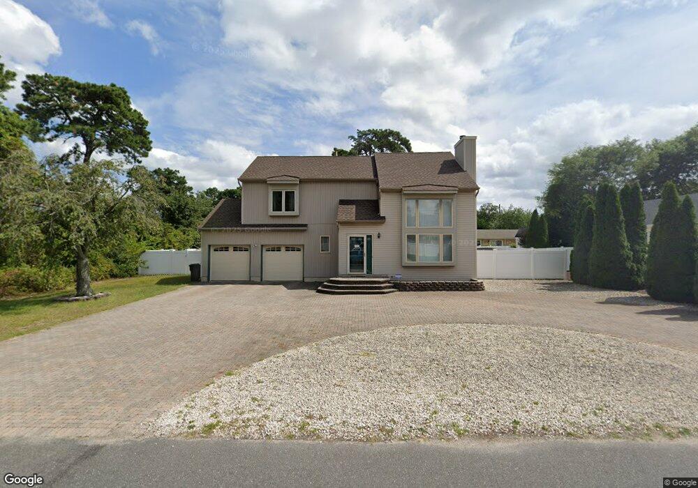
This home is located at 428 Miller Ave, Brick, NJ 08724 and is currently estimated at $613,785, approximately $358 per square foot. 428 Miller Ave is a home located in Ocean County with nearby schools including Veterans Memorial Elementary School, Veterans Memorial Middle School, and Brick Township Memorial High School.
Ownership History
Date
Name
Owned For
Owner Type
Purchase Details
Closed on
Feb 6, 2002
Sold by
Goff Darren
Bought by
Maiorino Albert and Mecca Christine
Current Estimated Value
Home Financials for this Owner
Home Financials are based on the most recent Mortgage that was taken out on this home.
Original Mortgage
$180,100
Outstanding Balance
$73,363
Interest Rate
6.85%
Estimated Equity
$540,422
Purchase Details
Closed on
Aug 31, 1995
Sold by
Rugo Eric
Bought by
Goff Darren
Home Financials for this Owner
Home Financials are based on the most recent Mortgage that was taken out on this home.
Original Mortgage
$123,000
Interest Rate
7.8%
Create a Home Valuation Report for This Property
The Home Valuation Report is an in-depth analysis detailing your home's value as well as a comparison with similar homes in the area
Home Values in the Area
Average Home Value in this Area
Purchase History
| Date | Buyer | Sale Price | Title Company |
|---|---|---|---|
| Maiorino Albert | $228,000 | -- | |
| Goff Darren | $154,000 | -- |
Source: Public Records
Mortgage History
| Date | Status | Borrower | Loan Amount |
|---|---|---|---|
| Open | Maiorino Albert | $180,100 | |
| Previous Owner | Goff Darren | $123,000 |
Source: Public Records
Tax History Compared to Growth
Tax History
| Year | Tax Paid | Tax Assessment Tax Assessment Total Assessment is a certain percentage of the fair market value that is determined by local assessors to be the total taxable value of land and additions on the property. | Land | Improvement |
|---|---|---|---|---|
| 2025 | $7,827 | $299,900 | $142,500 | $157,400 |
| 2024 | $7,429 | $299,900 | $142,500 | $157,400 |
| 2023 | $7,321 | $299,900 | $142,500 | $157,400 |
| 2022 | $7,321 | $299,900 | $142,500 | $157,400 |
| 2021 | $7,168 | $299,900 | $142,500 | $157,400 |
| 2020 | $7,075 | $299,900 | $142,500 | $157,400 |
| 2019 | $6,949 | $299,900 | $142,500 | $157,400 |
| 2018 | $6,790 | $299,900 | $142,500 | $157,400 |
| 2017 | $6,607 | $299,900 | $142,500 | $157,400 |
| 2016 | $6,571 | $299,900 | $142,500 | $157,400 |
| 2015 | $6,400 | $299,900 | $142,500 | $157,400 |
| 2014 | $6,346 | $299,900 | $142,500 | $157,400 |
Source: Public Records
Map
Nearby Homes
- 291 Prospect Dr
- 302 Maxwell Ct
- 432 18th Ave
- 405 17th Ave
- 853 Stengel Ave
- 861 Wraight Ave
- 384 18th Ave
- 775 Maple Ave
- 411 Hulse Ave
- 270 Westwood Place
- 404 Driscol Dr
- 445 Vista Ct
- 669 Spiral Dr
- 600 Driscol Dr
- 626-632 Summit Ave
- 47 Newport Ct Unit 6
- 519 6th Ave
- 658 Summit Ave
- 528 Azalea Dr
- 107 Brandywine Ct Unit 307
- 427 Austin Ave
- 434 Miller Ave
- 431 Austin Ave
- 427 Miller Ave
- 431 Miller Ave
- 436 Miller Ave
- 435 Miller Ave
- 424 Harris Ave
- 780 Burnt Tavern Rd
- 428 Austin Ave
- 438 Miller Ave
- 428 Harris Ave
- 786 Burnt Tavern Rd
- 784 Burnt Tavern Rd
- 439 Austin Ave
- 439 Miller Ave
- 432 Austin Ave
- 434 Harris Ave
- 792 Burnt Tavern Rd
- 434 Austin Ave