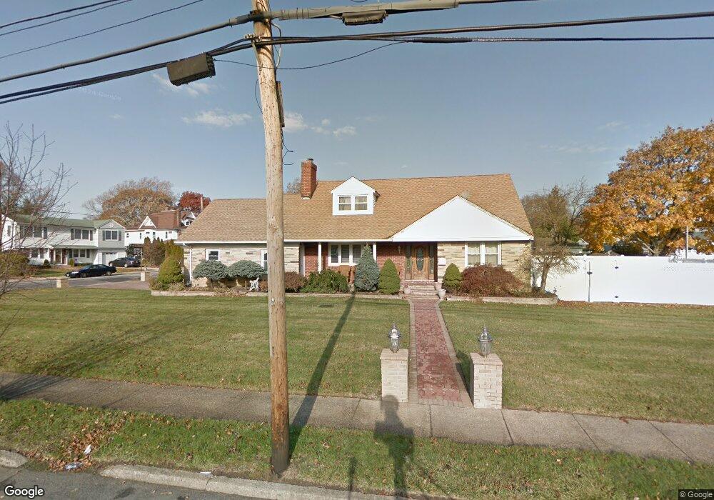
428 Southside Ave Freeport, NY 11520
Estimated Value: $745,000 - $816,440
--
Bed
3
Baths
1,932
Sq Ft
$404/Sq Ft
Est. Value
About This Home
This home is located at 428 Southside Ave, Freeport, NY 11520 and is currently estimated at $780,720, approximately $404 per square foot. 428 Southside Ave is a home located in Nassau County with nearby schools including Columbus Avenue School, Caroline G. Atkinson Intermediate School, and John W Dodd Middle School.
Ownership History
Date
Name
Owned For
Owner Type
Purchase Details
Closed on
Apr 24, 2018
Sold by
Pichardo Domingo and Sime Luz M
Bought by
Sime Luz M
Current Estimated Value
Purchase Details
Closed on
Jun 10, 2002
Sold by
Pichardo Domingo
Bought by
Pichardo Domingo and Pichardo Luz M
Purchase Details
Closed on
Dec 8, 2000
Sold by
Executor Daly James C
Bought by
Pichardo Domingo
Create a Home Valuation Report for This Property
The Home Valuation Report is an in-depth analysis detailing your home's value as well as a comparison with similar homes in the area
Home Values in the Area
Average Home Value in this Area
Purchase History
| Date | Buyer | Sale Price | Title Company |
|---|---|---|---|
| Sime Luz M | -- | None Available | |
| Sime Luz M | -- | None Available | |
| Pichardo Domingo | -- | -- | |
| Pichardo Domingo | -- | -- | |
| Pichardo Domingo | $260,000 | Percy M Samuel | |
| Pichardo Domingo | $260,000 | Percy M Samuel |
Source: Public Records
Tax History Compared to Growth
Tax History
| Year | Tax Paid | Tax Assessment Tax Assessment Total Assessment is a certain percentage of the fair market value that is determined by local assessors to be the total taxable value of land and additions on the property. | Land | Improvement |
|---|---|---|---|---|
| 2025 | $9,561 | $485 | $212 | $273 |
| 2024 | $1,041 | $486 | $212 | $274 |
| 2023 | $8,546 | $495 | $216 | $279 |
| 2022 | $8,546 | $495 | $216 | $279 |
| 2021 | $11,882 | $489 | $214 | $275 |
| 2020 | $7,956 | $543 | $442 | $101 |
| 2019 | $965 | $582 | $390 | $192 |
| 2018 | $3,671 | $624 | $0 | $0 |
| 2017 | $7,108 | $707 | $439 | $268 |
| 2016 | $8,169 | $723 | $389 | $334 |
| 2015 | $1,102 | $763 | $410 | $353 |
| 2014 | $1,102 | $763 | $410 | $353 |
| 2013 | $1,204 | $882 | $474 | $408 |
Source: Public Records
Map
Nearby Homes
- 451 Atlantic Ave
- 481 Archer St
- 306 Park Ave
- 437 Ray St
- 523 Archer St
- 61 Morton Ave
- 557 Southside Ave
- 16 Johnson Place
- 230 Park Ave
- 531 Ray St Unit 10
- 116 Westend Ave Unit 8
- 116 Westend Ave Unit 21
- 116 Westend Ave Unit 6
- 178 Washington St
- 119 S Bay Ave
- 173 Cedar St
- 153 Westend Ave
- 2864 Eastern Blvd
- 1073 Thomas Ave
- 103 Rose St
- 323 Locust Ave
- 311 Locust Ave
- 44 Onslow Place
- 322 Locust Ave
- 423 Southside Ave
- 425 Southside Ave
- 419 Southside Ave
- 38 Onslow Place
- 320 Locust Ave
- 427 Southside Ave
- 305 Locust Ave
- 417 Southside Ave
- 312 Locust Ave
- 431 Southside Ave
- 32 Onslow Place
- 413 Southside Ave
- 446 Southside Ave
- 301 Locust Ave
- 308 Locust Ave
- 437 Southside Ave