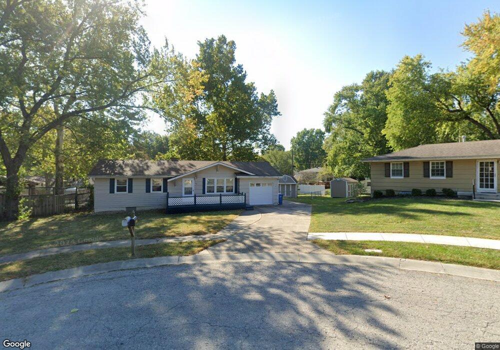
428 Wilshire Cir Liberty, MO 64068
Estimated Value: $231,000 - $255,000
3
Beds
1
Bath
936
Sq Ft
$257/Sq Ft
Est. Value
About This Home
This home is located at 428 Wilshire Cir, Liberty, MO 64068 and is currently estimated at $240,763, approximately $257 per square foot. 428 Wilshire Cir is a home located in Clay County with nearby schools including Alexander Doniphan Elementary School, Discovery Middle School, and Liberty High School.
Ownership History
Date
Name
Owned For
Owner Type
Purchase Details
Closed on
Oct 24, 2006
Sold by
Anderson Kenneth L and Anderson Ruth Ann
Bought by
Gass Debra S
Current Estimated Value
Home Financials for this Owner
Home Financials are based on the most recent Mortgage that was taken out on this home.
Original Mortgage
$78,500
Outstanding Balance
$7,210
Interest Rate
6.28%
Mortgage Type
Purchase Money Mortgage
Estimated Equity
$233,553
Purchase Details
Closed on
Feb 19, 2004
Sold by
Anderson Kenneth R
Bought by
Anderson Kenneth L and Sims Sharon L
Create a Home Valuation Report for This Property
The Home Valuation Report is an in-depth analysis detailing your home's value as well as a comparison with similar homes in the area
Home Values in the Area
Average Home Value in this Area
Purchase History
| Date | Buyer | Sale Price | Title Company |
|---|---|---|---|
| Gass Debra S | -- | Mokan Title Services Llc | |
| Anderson Kenneth L | -- | -- |
Source: Public Records
Mortgage History
| Date | Status | Borrower | Loan Amount |
|---|---|---|---|
| Open | Gass Debra S | $78,500 |
Source: Public Records
Tax History Compared to Growth
Tax History
| Year | Tax Paid | Tax Assessment Tax Assessment Total Assessment is a certain percentage of the fair market value that is determined by local assessors to be the total taxable value of land and additions on the property. | Land | Improvement |
|---|---|---|---|---|
| 2025 | $1,874 | $27,970 | -- | -- |
| 2024 | $1,874 | $24,360 | -- | -- |
| 2023 | $1,905 | $24,360 | $0 | $0 |
| 2022 | $1,748 | $22,060 | $0 | $0 |
| 2021 | $1,734 | $22,059 | $6,650 | $15,409 |
| 2020 | $1,711 | $20,440 | $0 | $0 |
| 2019 | $1,711 | $20,440 | $0 | $0 |
| 2018 | $1,508 | $17,690 | $0 | $0 |
| 2017 | $1,494 | $17,690 | $3,800 | $13,890 |
| 2016 | $1,494 | $17,690 | $3,800 | $13,890 |
| 2015 | $1,494 | $17,690 | $3,800 | $13,890 |
| 2014 | $1,412 | $16,590 | $3,800 | $12,790 |
Source: Public Records
Map
Nearby Homes
- 415 Monterey Ave
- 509 Belmont St
- 420 Belmont St
- 1124 Amesbury Ave
- 1323 Amesbury Ave
- 918 Amesbury Ave
- 862 Amesbury Ave
- 1507 Amesbury Ave
- 1218 Canterbury Ln
- 716 Bristol Ct
- 1733 Welleslay Ln
- 1537 Canterbury Ln
- 1331 Park Ln
- 253 S Stewart Rd
- 1317 Park Ln
- 1304 Wellington Way
- 7908 N Ditzler Ave
- 1327 Easton Ct
- 11852 N Kentucky Ave
- 9102 NE 79th Terrace
- 424 Wilshire Cir
- 436 Wilshire Blvd
- 432 Wilshire Blvd
- 427 Monterey Ave
- 423 Monterey Ave
- 431 Monterey Ave
- 419 Monterey Ave
- 412 Wilshire Cir
- 408 Wilshire Blvd
- 420 Wilshire Cir
- 416 Wilshire Cir
- 433 Wilshire Blvd
- 421 Wilshire Blvd
- 421 Wilshire Blvd
- 411 Monterey Ave
- 404 Wilshire Blvd
- 429 Wilshire Blvd
- 425 Wilshire Blvd
- 417 Wilshire Blvd
- 437 Wilshire Blvd