Estimated Value: $192,000 - $266,000
3
Beds
2
Baths
1,870
Sq Ft
$118/Sq Ft
Est. Value
About This Home
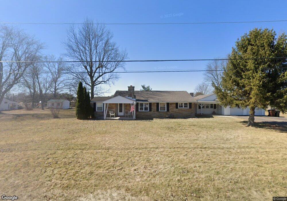
This home is located at 4285 State Route 235, Ada, OH 45810 and is currently estimated at $220,893, approximately $118 per square foot. 4285 State Route 235 is a home located in Hardin County with nearby schools including Ada Elementary School and Ada High School.
Ownership History
Date
Name
Owned For
Owner Type
Purchase Details
Closed on
Jul 22, 2021
Sold by
Brooks Sunday C Moser
Bought by
Collins Isaac Daniel and Collins Aspen Tenille
Current Estimated Value
Home Financials for this Owner
Home Financials are based on the most recent Mortgage that was taken out on this home.
Original Mortgage
$147,250
Outstanding Balance
$133,729
Interest Rate
2.96%
Mortgage Type
Future Advance Clause Open End Mortgage
Estimated Equity
$87,164
Purchase Details
Closed on
Jul 18, 2021
Sold by
Brooks Jeffrey C
Bought by
Brooks Sunday C Moser
Home Financials for this Owner
Home Financials are based on the most recent Mortgage that was taken out on this home.
Original Mortgage
$147,250
Outstanding Balance
$133,729
Interest Rate
2.96%
Mortgage Type
Future Advance Clause Open End Mortgage
Estimated Equity
$87,164
Purchase Details
Closed on
Nov 28, 1994
Bought by
Moser Donald G and Moser Laverna
Purchase Details
Closed on
Jan 15, 1993
Bought by
Hubbell Wilma Mae and Hubbell Bonn
Purchase Details
Closed on
Dec 30, 1992
Create a Home Valuation Report for This Property
The Home Valuation Report is an in-depth analysis detailing your home's value as well as a comparison with similar homes in the area
Home Values in the Area
Average Home Value in this Area
Purchase History
| Date | Buyer | Sale Price | Title Company |
|---|---|---|---|
| Collins Isaac Daniel | $155,000 | None Available | |
| Brooks Sunday C Moser | -- | None Available | |
| Moser Donald G | $77,000 | -- | |
| Hubbell Wilma Mae | $22,700 | -- | |
| -- | -- | -- |
Source: Public Records
Mortgage History
| Date | Status | Borrower | Loan Amount |
|---|---|---|---|
| Open | Collins Isaac Daniel | $147,250 |
Source: Public Records
Tax History Compared to Growth
Tax History
| Year | Tax Paid | Tax Assessment Tax Assessment Total Assessment is a certain percentage of the fair market value that is determined by local assessors to be the total taxable value of land and additions on the property. | Land | Improvement |
|---|---|---|---|---|
| 2024 | $1,750 | $47,140 | $8,750 | $38,390 |
| 2023 | $1,750 | $47,140 | $8,750 | $38,390 |
| 2022 | $1,952 | $45,770 | $4,410 | $41,360 |
| 2021 | $1,743 | $45,770 | $4,410 | $41,360 |
| 2020 | $1,767 | $45,770 | $4,410 | $41,360 |
| 2019 | $1,497 | $40,470 | $4,200 | $36,270 |
| 2018 | $1,463 | $40,470 | $4,200 | $36,270 |
| 2017 | $1,426 | $40,470 | $4,200 | $36,270 |
| 2016 | $989 | $31,800 | $3,680 | $28,120 |
| 2015 | $1,322 | $31,800 | $3,680 | $28,120 |
| 2014 | $496 | $31,800 | $3,680 | $28,120 |
| 2013 | $528 | $32,020 | $3,680 | $28,340 |
Source: Public Records
Map
Nearby Homes
- 710 S Main St
- 623 S Gilbert St
- 617 S Gilbert St
- 613 S Gilbert St
- 314 E University Ave
- 301 S Main St
- 308-310 S Simon St
- 211 W Buckeye Ave Unit 211 1/2
- 118 W Buckeye Ave
- 211 S Main St
- 210 N Gilbert St
- 212 N Simon St
- 4071 Township Road 35
- 442 Edwards St
- 444 Edwards St Unit A, B
- 444 Edwards St Unit 2
- 128 W North Ave
- 629 N Main St
- 2864 Ohio 309
- 2072 State Route 235