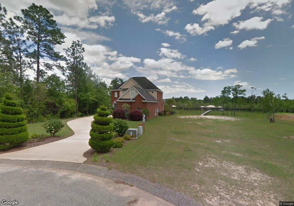
4289 River Oaks Ln Mobile, AL 36619
Cypress Shores NeighborhoodEstimated Value: $701,000 - $897,000
4
Beds
4
Baths
3,969
Sq Ft
$206/Sq Ft
Est. Value
About This Home
This home is located at 4289 River Oaks Ln, Mobile, AL 36619 and is currently estimated at $818,613, approximately $206 per square foot. 4289 River Oaks Ln is a home located in Mobile County with nearby schools including Mary W Burroughs Elementary School, Katherine H Hankins Middle School, and Theodore High School.
Ownership History
Date
Name
Owned For
Owner Type
Purchase Details
Closed on
Jul 30, 2007
Sold by
Hembree Michael Shane and Hembree Deborah B
Bought by
Dismukes Julie and Dismukes Joseph
Current Estimated Value
Home Financials for this Owner
Home Financials are based on the most recent Mortgage that was taken out on this home.
Original Mortgage
$275,000
Outstanding Balance
$171,611
Interest Rate
6.65%
Mortgage Type
New Conventional
Estimated Equity
$647,002
Create a Home Valuation Report for This Property
The Home Valuation Report is an in-depth analysis detailing your home's value as well as a comparison with similar homes in the area
Home Values in the Area
Average Home Value in this Area
Purchase History
| Date | Buyer | Sale Price | Title Company |
|---|---|---|---|
| Dismukes Julie | $580,000 | Reli Inc |
Source: Public Records
Mortgage History
| Date | Status | Borrower | Loan Amount |
|---|---|---|---|
| Open | Dismukes Julie | $275,000 |
Source: Public Records
Tax History
| Year | Tax Paid | Tax Assessment Tax Assessment Total Assessment is a certain percentage of the fair market value that is determined by local assessors to be the total taxable value of land and additions on the property. | Land | Improvement |
|---|---|---|---|---|
| 2025 | $4,250 | $67,810 | $9,660 | $58,150 |
| 2024 | $4,250 | $65,260 | $9,660 | $55,600 |
| 2023 | $4,088 | $63,880 | $8,750 | $55,130 |
| 2022 | $3,155 | $50,730 | $8,750 | $41,980 |
| 2021 | $3,184 | $51,190 | $8,750 | $42,440 |
| 2020 | $3,213 | $51,650 | $8,750 | $42,900 |
| 2019 | $3,279 | $52,700 | $0 | $0 |
| 2018 | $3,335 | $53,580 | $0 | $0 |
| 2017 | $3,254 | $52,300 | $0 | $0 |
| 2016 | $3,014 | $48,520 | $0 | $0 |
| 2013 | $2,803 | $47,380 | $0 | $0 |
Source: Public Records
Map
Nearby Homes
- 5533 River Landing Dr
- 5476 Henning Dr W
- 5409 Rabbit Creek Dr
- 0 Rangeline Rd Unit 7655799
- 2308 Henning Dr N
- 5710 Spring Landing Dr
- 0 Worth Dr Unit 7748082
- 0 Worth Dr Unit 7747878
- 4082 Dawson Dr
- 5517 Rabbit Creek Dr
- 5541 Riverwood Landing
- 4323 Downey Dr
- 0 Downey Dr Unit 7684534
- 3765 Rabbit Creek Ct
- 5030 Cole Dr E
- 3720 Rabbit Creek Ct
- 5001 Audubon Dr
- 6066 Todd Acres Dr
- 0 Audubon Dr Unit 7716268
- 4219 Canal Dr
- 4301 River Oaks Ln Unit 9
- 4301 River Oaks Ln
- 0 River Oaks Ln Unit 208480
- 0 River Oaks Ln Unit 1 0218148
- 0 River Oaks Ln Unit 1 0199420
- 0 River Oaks Ln Unit 1 0189774
- 0 River Oaks Ln Unit 5 0189745
- 0 River Oaks Ln Unit 5 0171656
- 0 River Oaks Ln Unit 1 0171652
- 0 River Oaks Ln Unit 7 0502701
- 4371 River Oaks Ln
- 4217 River Oaks Ln
- 4273 River Oaks Ln
- 4193 River Oaks Ln
- 5790 Riverchase Dr N
- 5810 Riverchase Dr N
- 5640 Commerce Blvd E
- 5640 Commerce Blvd E
- 5830 Riverchase Dr N
- 5630 Rangeline Rd
Your Personal Tour Guide
Ask me questions while you tour the home.