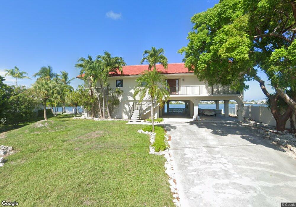
429 122nd Street Ocean Marathon, FL 33050
Estimated Value: $2,205,292 - $2,644,000
3
Beds
3
Baths
3,008
Sq Ft
$786/Sq Ft
Est. Value
About This Home
This home is located at 429 122nd Street Ocean, Marathon, FL 33050 and is currently estimated at $2,363,573, approximately $785 per square foot. 429 122nd Street Ocean is a home located in Monroe County with nearby schools including Stanley Switlik Elementary School, Marathon Middle High School, and Coral Shores High School.
Ownership History
Date
Name
Owned For
Owner Type
Purchase Details
Closed on
May 7, 1996
Sold by
Harco Distributors Inc
Bought by
Layson Walter E and Layson Diana O
Current Estimated Value
Purchase Details
Closed on
Sep 1, 1989
Bought by
Layson Walter E and Layson Diana O
Purchase Details
Closed on
May 1, 1989
Bought by
Layson Walter E and Layson Diana O
Purchase Details
Closed on
Mar 1, 1979
Bought by
Layson Walter E and Layson Diana O
Create a Home Valuation Report for This Property
The Home Valuation Report is an in-depth analysis detailing your home's value as well as a comparison with similar homes in the area
Home Values in the Area
Average Home Value in this Area
Purchase History
| Date | Buyer | Sale Price | Title Company |
|---|---|---|---|
| Layson Walter E | $445,000 | -- | |
| Layson Walter E | $399,000 | -- | |
| Layson Walter E | -- | -- | |
| Layson Walter E | $28,500 | -- |
Source: Public Records
Tax History Compared to Growth
Tax History
| Year | Tax Paid | Tax Assessment Tax Assessment Total Assessment is a certain percentage of the fair market value that is determined by local assessors to be the total taxable value of land and additions on the property. | Land | Improvement |
|---|---|---|---|---|
| 2025 | $15,571 | $2,789,079 | $2,329,705 | $459,374 |
| 2024 | $13,342 | $2,235,071 | $1,779,006 | $456,065 |
| 2023 | $13,342 | $1,619,902 | $1,178,450 | $441,452 |
| 2022 | $11,942 | $1,311,605 | $888,370 | $423,235 |
| 2021 | $10,809 | $987,533 | $607,355 | $380,178 |
| 2020 | $10,402 | $963,417 | $573,361 | $390,056 |
| 2019 | $9,811 | $951,927 | $556,295 | $395,632 |
| 2018 | $8,285 | $876,462 | $562,030 | $314,432 |
| 2017 | $8,445 | $942,972 | $0 | $0 |
| 2016 | $9,158 | $1,190,672 | $0 | $0 |
| 2015 | $8,311 | $1,045,525 | $0 | $0 |
| 2014 | $6,294 | $528,878 | $0 | $0 |
Source: Public Records
Map
Nearby Homes
- 417 122 Street Ocean
- 12399 Overseas Hwy Unit 12
- 1220 122nd Street Ocean
- 750 9th St
- 12411 Overseas Hwy Unit 57C
- 12411 Overseas Hwy Unit 30A
- 12411 Overseas Hwy Unit 37C
- 12411 Overseas Hwy Unit 34C
- 12411 Overseas Hwy Unit 35A
- 12411 Overseas Hwy Unit 16A
- 12411 Overseas Hwy Unit 56C
- 12411 Overseas Hwy Unit 4C
- 640 9th St
- 641 9th St
- 47 Sadowski
- 97 Coral Ln
- 571 8th St
- 580 9th St
- 14 125th Street Gulf
- 65 Coral Ln
- 437 122nd Street Ocean
- 425 122nd Street Ocean
- 430 122nd Street Ocean
- 433 122nd Street Ocean
- 417 122nd Street Ocean
- 415 122nd Street Ocean
- 420 122nd St
- 435 122nd Street Ocean
- 450 122nd St
- 450 122nd Street Ocean
- 411 122nd Street Ocean
- 414 122nd Street Ocean
- 455 122nd Street Ocean
- 407 122nd Street Ocean
- 412 122nd Street Ocean
- 465 122nd Street Ocean
- 12399 Overseas (50'Boat Slip) Hwy Unit Wet Slip 22
- 470 122nd St
- 410 122nd Street Ocean
- 475 122nd Street Ocean