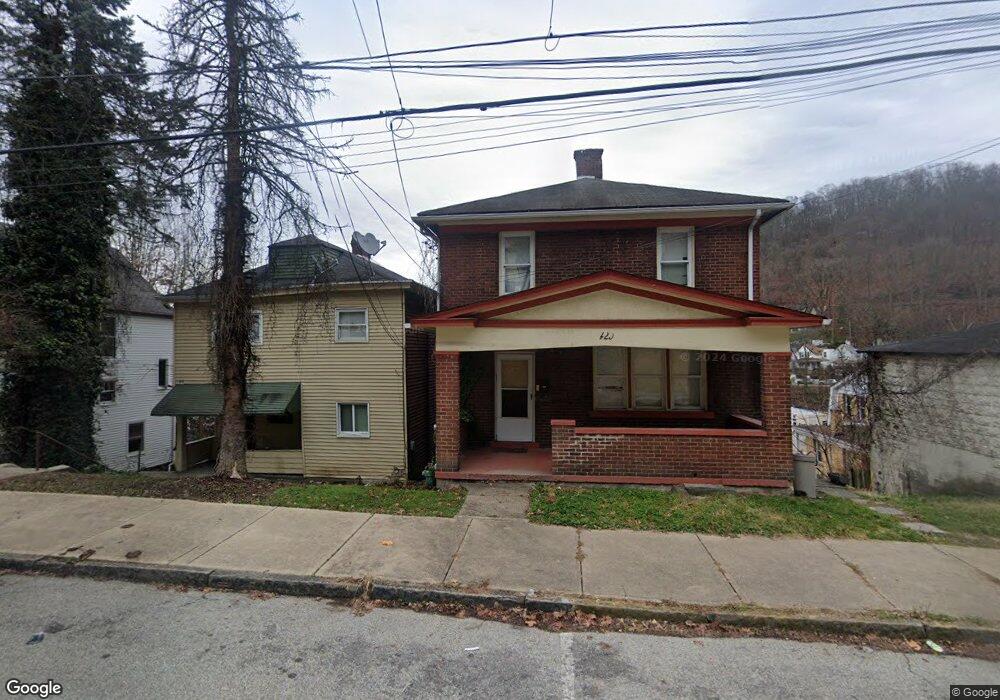
429 Card Ave Wilmerding, PA 15148
Estimated Value: $50,000 - $107,000
3
Beds
2
Baths
1,296
Sq Ft
$58/Sq Ft
Est. Value
About This Home
This home is located at 429 Card Ave, Wilmerding, PA 15148 and is currently estimated at $74,944, approximately $57 per square foot. 429 Card Ave is a home located in Allegheny County with nearby schools including Logan Elementary School, Propel Cs-East, and Christ Lutheran School.
Ownership History
Date
Name
Owned For
Owner Type
Purchase Details
Closed on
Apr 8, 2021
Sold by
Coal Hill Partners Llc
Bought by
Tna Investments Llc
Current Estimated Value
Purchase Details
Closed on
Jan 15, 2009
Sold by
Compass S B
Bought by
Rilane Props L L C
Home Financials for this Owner
Home Financials are based on the most recent Mortgage that was taken out on this home.
Original Mortgage
$99,200
Interest Rate
5.52%
Mortgage Type
New Conventional
Purchase Details
Closed on
Jun 2, 2008
Sold by
Schnars Jeffrey L
Bought by
Compass Fsb
Create a Home Valuation Report for This Property
The Home Valuation Report is an in-depth analysis detailing your home's value as well as a comparison with similar homes in the area
Home Values in the Area
Average Home Value in this Area
Purchase History
| Date | Buyer | Sale Price | Title Company |
|---|---|---|---|
| Tna Investments Llc | $40,000 | -- | |
| T N A Invests L L C | $40,000 | None Available | |
| Rilane Props L L C | $50,000 | -- | |
| Compass Fsb | $1,517 | -- |
Source: Public Records
Mortgage History
| Date | Status | Borrower | Loan Amount |
|---|---|---|---|
| Previous Owner | Rilane Props L L C | $99,200 |
Source: Public Records
Tax History Compared to Growth
Tax History
| Year | Tax Paid | Tax Assessment Tax Assessment Total Assessment is a certain percentage of the fair market value that is determined by local assessors to be the total taxable value of land and additions on the property. | Land | Improvement |
|---|---|---|---|---|
| 2025 | $1,135 | $25,400 | $6,300 | $19,100 |
| 2024 | $1,135 | $25,400 | $6,300 | $19,100 |
| 2023 | $1,855 | $41,500 | $6,300 | $35,200 |
| 2022 | $1,855 | $41,500 | $6,300 | $35,200 |
| 2021 | $1,772 | $41,500 | $6,300 | $35,200 |
| 2020 | $1,772 | $41,500 | $6,300 | $35,200 |
| 2019 | $1,772 | $41,500 | $6,300 | $35,200 |
| 2018 | $196 | $41,500 | $6,300 | $35,200 |
| 2017 | $1,731 | $41,500 | $6,300 | $35,200 |
| 2016 | $196 | $41,500 | $6,300 | $35,200 |
| 2015 | $196 | $41,500 | $6,300 | $35,200 |
| 2014 | $1,671 | $41,500 | $6,300 | $35,200 |
Source: Public Records
Map
Nearby Homes
- 428 Card Ave
- 354 Marguerite Ave
- 42 Sprague St
- 424 Desota St
- 320 Mystic Ave
- 834 Florence Ave
- 846 Florence Ave
- 906 Florence Ave
- 853 Florence Ave
- 360 Edna St
- 518 Middle Ave
- 969 5th Ave
- 957 5th Ave
- 722 5th Ave
- 1034 Park Ave
- 438 Miami St
- 715 Greensburg Pike
- 605 Pittsburgh St
- 607 Pittsburgh St
- 230 Kline Ave
- 427 Card Ave
- 610 Brown Ave Unit 612
- 610-612 Brown St
- 453 Card Ave
- 425 Card Ave
- 614 Brown Ave
- 604 Brown St
- 604 Brown Ave
- 450 Caldwell Ave
- 421 Card Ave
- 446 Caldwell Ave
- 444 Caldwell Ave
- 432 Card Ave
- 436 Card Ave
- 417 Card Ave
- 438 Caldwell Ave
- 440 Card Ave
- 424 Card Ave
- 500 Westinghouse Ave
- 502 Westinghouse Ave