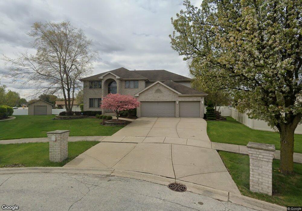
429 Castle Ct Matteson, IL 60443
Old Matteson NeighborhoodEstimated Value: $437,307 - $591,000
4
Beds
4
Baths
4,900
Sq Ft
$100/Sq Ft
Est. Value
About This Home
This home is located at 429 Castle Ct, Matteson, IL 60443 and is currently estimated at $489,577, approximately $99 per square foot. 429 Castle Ct is a home located in Cook County with nearby schools including Illinois School, Arcadia Elementary School, and Indiana Elementary School.
Ownership History
Date
Name
Owned For
Owner Type
Purchase Details
Closed on
Jun 17, 2010
Sold by
Chicago Title & Trust Company
Bought by
Kennedy Suggs Laverne
Current Estimated Value
Purchase Details
Closed on
Jun 18, 2007
Sold by
Fultz Roy L
Bought by
Chicago Title & Trust Co
Purchase Details
Closed on
Feb 21, 2007
Sold by
Anthony Michael and Anthony Antrenette
Bought by
Fultz Roy
Purchase Details
Closed on
Mar 19, 2004
Sold by
State Bank Of Countryside
Bought by
Anthony Michael and Anthony Antrenette
Create a Home Valuation Report for This Property
The Home Valuation Report is an in-depth analysis detailing your home's value as well as a comparison with similar homes in the area
Home Values in the Area
Average Home Value in this Area
Purchase History
| Date | Buyer | Sale Price | Title Company |
|---|---|---|---|
| Kennedy Suggs Laverne | $380,000 | Chicago Title Insurance Co | |
| Chicago Title & Trust Co | -- | None Available | |
| Fultz Roy | $640,000 | None Available | |
| Anthony Michael | $308,000 | -- |
Source: Public Records
Tax History
| Year | Tax Paid | Tax Assessment Tax Assessment Total Assessment is a certain percentage of the fair market value that is determined by local assessors to be the total taxable value of land and additions on the property. | Land | Improvement |
|---|---|---|---|---|
| 2025 | $14,879 | $36,000 | $13,495 | $22,505 |
| 2024 | $14,879 | $36,000 | $13,495 | $22,505 |
| 2023 | $15,519 | $36,000 | $13,495 | $22,505 |
| 2022 | $15,519 | $28,607 | $11,655 | $16,952 |
| 2021 | $15,732 | $28,606 | $11,655 | $16,951 |
| 2020 | $14,570 | $28,606 | $11,655 | $16,951 |
| 2019 | $15,397 | $29,750 | $10,428 | $19,322 |
| 2018 | $15,395 | $29,750 | $10,428 | $19,322 |
| 2017 | $14,779 | $29,750 | $10,428 | $19,322 |
| 2016 | $13,809 | $28,083 | $9,201 | $18,882 |
| 2015 | $13,689 | $28,083 | $9,201 | $18,882 |
| 2014 | $13,260 | $28,083 | $9,201 | $18,882 |
| 2013 | $14,042 | $32,532 | $9,201 | $23,331 |
Source: Public Records
Map
Nearby Homes
- 620 Larkspur Ln
- 4500 203rd St
- 744 Academy Ave
- 20813 Homeland Rd
- 820 School Ave
- 722 Kostner Ave
- 858 Academy Ave
- 153 Treehouse Rd
- 135 Treehouse Rd
- 4325 Oakwood Ln
- 4141 204th St
- 98 Lawrence Ln
- 154 Sundance Rd
- 4613 Lindenwood Ct
- 175 Owen St
- 4110 Applewood Ln
- 78 Kenneth St
- 763 Cambridge Ave
- 340 Maryview Ct
- 831 Violet Ln
- 437 Homeland Rd
- 425 Castle Ct
- 433 Homeland Rd
- 441 Homeland Rd
- 600 Goldenrod Cir
- 445 Homeland Rd
- 421 Castle Ct
- 604 Goldenrod Cir
- 501 Homeland Rd
- 413 Homeland Rd
- 417 Castle Ct Unit 3
- 601 Goldenrod Cir
- 505 Homeland Rd
- 438 Homeland Rd
- 608 Goldenrod Cir
- 605 Goldenrod Cir
- 430 Homeland Rd
- 434 Homeland Rd
- 434 Homeland Rd
- 4600 Morning Glory Dr
Your Personal Tour Guide
Ask me questions while you tour the home.