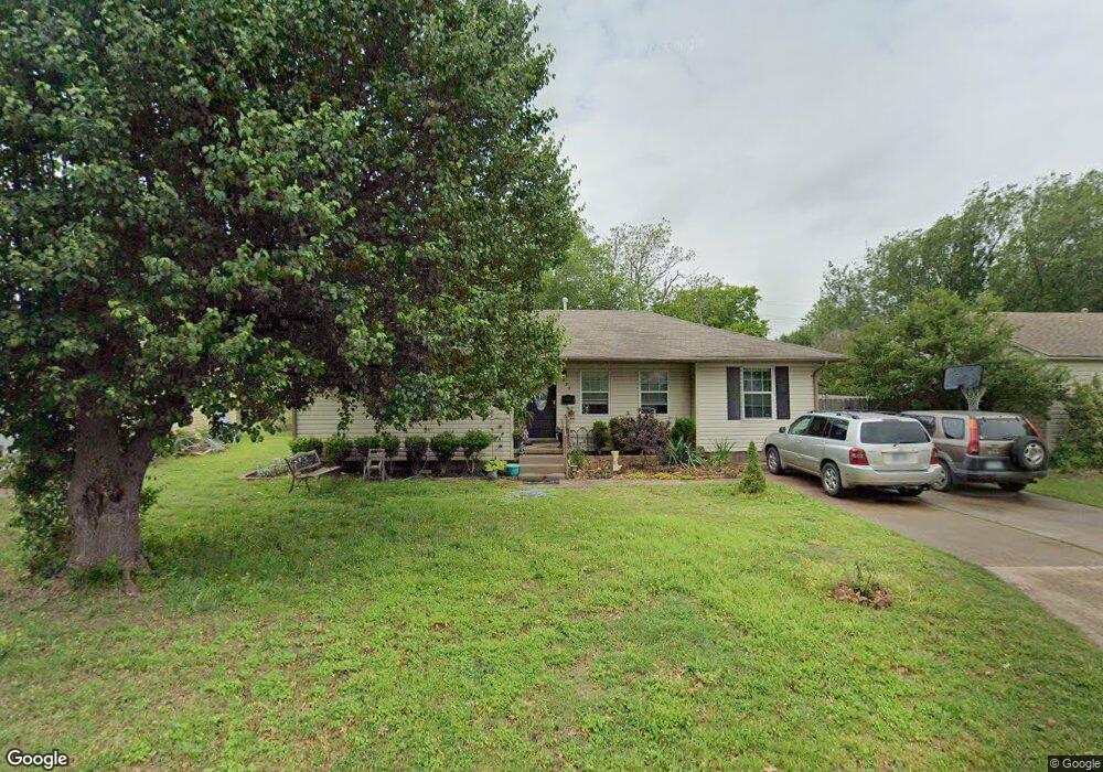
429 Lester Blvd Duncan, OK 73533
Estimated Value: $113,000 - $137,000
3
Beds
1
Bath
1,276
Sq Ft
$99/Sq Ft
Est. Value
About This Home
This home is located at 429 Lester Blvd, Duncan, OK 73533 and is currently estimated at $126,612, approximately $99 per square foot. 429 Lester Blvd is a home located in Stephens County with nearby schools including Horace Mann Elementary School, Duncan Middle School, and Duncan High School.
Ownership History
Date
Name
Owned For
Owner Type
Purchase Details
Closed on
Oct 9, 2015
Sold by
Leanos Robert and Leanos Maria C
Bought by
Dianeely Tammy
Current Estimated Value
Purchase Details
Closed on
Sep 25, 2013
Sold by
Jpmorgan Chase Bank Na
Bought by
Leanos Robert and Leanos Maria C
Purchase Details
Closed on
Sep 3, 2013
Sold by
Stephens County Sheriff
Purchase Details
Closed on
Oct 8, 2002
Sold by
Payne Richard and Payne Shari
Purchase Details
Closed on
Oct 16, 1997
Sold by
Shults Lester Leon
Purchase Details
Closed on
Jun 15, 1990
Create a Home Valuation Report for This Property
The Home Valuation Report is an in-depth analysis detailing your home's value as well as a comparison with similar homes in the area
Home Values in the Area
Average Home Value in this Area
Purchase History
| Date | Buyer | Sale Price | Title Company |
|---|---|---|---|
| Dianeely Tammy | $76,000 | None Available | |
| Leanos Robert | $25,000 | Oklahoma Reo Closing&Title S | |
| -- | -- | -- | |
| -- | -- | -- | |
| -- | $39,500 | -- | |
| -- | $3,500 | -- |
Source: Public Records
Tax History Compared to Growth
Tax History
| Year | Tax Paid | Tax Assessment Tax Assessment Total Assessment is a certain percentage of the fair market value that is determined by local assessors to be the total taxable value of land and additions on the property. | Land | Improvement |
|---|---|---|---|---|
| 2025 | $813 | $10,023 | $825 | $9,198 |
| 2024 | $813 | $9,545 | $825 | $8,720 |
| 2023 | $813 | $9,091 | $825 | $8,266 |
| 2022 | $787 | $9,262 | $825 | $8,437 |
| 2021 | $790 | $9,278 | $825 | $8,453 |
| 2020 | $727 | $8,416 | $825 | $7,591 |
| 2019 | $703 | $8,122 | $825 | $7,297 |
| 2018 | $736 | $8,328 | $825 | $7,503 |
| 2017 | $676 | $7,866 | $825 | $7,041 |
| 2016 | $717 | $8,440 | $825 | $7,615 |
| 2015 | $264 | $2,763 | $825 | $1,938 |
| 2014 | $264 | $2,763 | $825 | $1,938 |
Source: Public Records
Map
Nearby Homes
- 2210 Western Dr
- 210 N 22nd St
- 2011 2011 W Oak Ave
- 209 N 22nd St
- 2006 W Oak Ave
- 507 N Alice Dr
- 174831 N 2844 Rd
- 2108 Ave
- 2206 2206 W Spruce
- 1099 N 19th St
- 2204 W Parkview Ave
- 2230 W Spruce St
- 201 N 23rd St
- 1812 W Walnut Ave
- 1929 W Chisholm Dr
- 1807 W Chisholm Dr
- 1902 W Randall Ave
- 812 N 15th St
- 2110 W Main St
- 2110 W Amhurst Ave
- 427 Lester Blvd
- 431 Lester Blvd
- 430 N 20th St
- 432 N 20th St
- 428 N 20th St
- 430 Lester Blvd
- 425 Lester Blvd
- 432 432 N 20th St
- 428 Lester Blvd
- 432 Lester Blvd
- 434 N 20th St
- 426 N 20th St
- 426 Lester Blvd
- 434 Lester Blvd
- 423 Lester Blvd
- 424 N 20th St
- 424 Lester Blvd
- 427 N 19th St
- 425 N 19th St
- 429 N 19th St