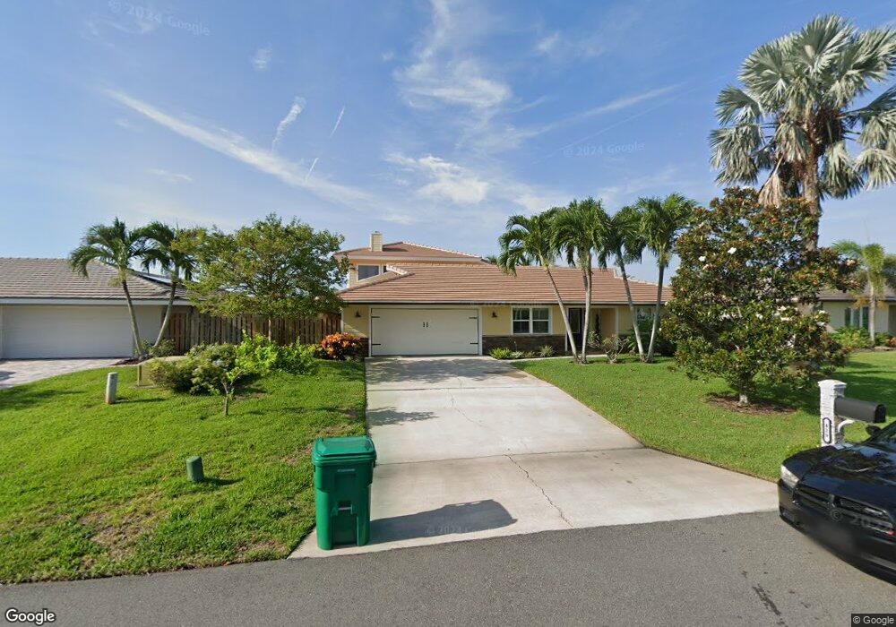
429 Red Sail Way Satellite Beach, FL 32937
Estimated Value: $800,000 - $1,507,000
4
Beds
2
Baths
3,408
Sq Ft
$314/Sq Ft
Est. Value
About This Home
This home is located at 429 Red Sail Way, Satellite Beach, FL 32937 and is currently estimated at $1,071,453, approximately $314 per square foot. 429 Red Sail Way is a home located in Brevard County with nearby schools including Sea Park Elementary School, Satellite Senior High School, and DeLaura Middle School.
Ownership History
Date
Name
Owned For
Owner Type
Purchase Details
Closed on
Jan 21, 2021
Sold by
Glisson Wayne O and Glisson Kristy S
Bought by
Glisson Wayne O and Glisson Kristy S
Current Estimated Value
Purchase Details
Closed on
May 11, 2005
Sold by
Brown Fayette and Brown Laurie W
Bought by
Glisson Wayne O and Glisson Kristy S
Home Financials for this Owner
Home Financials are based on the most recent Mortgage that was taken out on this home.
Original Mortgage
$350,000
Interest Rate
5.98%
Purchase Details
Closed on
Jun 22, 2004
Sold by
Brown Fayette and Brown Laurie W
Bought by
Brown Fayette and Brown Laurie W
Create a Home Valuation Report for This Property
The Home Valuation Report is an in-depth analysis detailing your home's value as well as a comparison with similar homes in the area
Home Values in the Area
Average Home Value in this Area
Purchase History
| Date | Buyer | Sale Price | Title Company |
|---|---|---|---|
| Glisson Wayne O | -- | None Available | |
| Glisson Wayne O | $824,900 | -- | |
| Brown Fayette | -- | -- |
Source: Public Records
Mortgage History
| Date | Status | Borrower | Loan Amount |
|---|---|---|---|
| Closed | Glisson Wayne O | $350,000 |
Source: Public Records
Tax History Compared to Growth
Tax History
| Year | Tax Paid | Tax Assessment Tax Assessment Total Assessment is a certain percentage of the fair market value that is determined by local assessors to be the total taxable value of land and additions on the property. | Land | Improvement |
|---|---|---|---|---|
| 2025 | $5,364 | $433,630 | -- | -- |
| 2024 | $5,307 | $421,410 | -- | -- |
| 2023 | $5,307 | $409,140 | $0 | $0 |
| 2022 | $4,900 | $392,030 | $0 | $0 |
| 2021 | $5,131 | $380,620 | $0 | $0 |
| 2020 | $5,074 | $375,370 | $0 | $0 |
| 2019 | $5,043 | $366,940 | $0 | $0 |
| 2018 | $5,068 | $360,100 | $0 | $0 |
| 2017 | $5,140 | $352,700 | $0 | $0 |
| 2016 | $5,249 | $345,450 | $195,000 | $150,450 |
| 2015 | $4,873 | $343,050 | $195,000 | $148,050 |
| 2014 | $4,920 | $340,330 | $180,000 | $160,330 |
Source: Public Records
Map
Nearby Homes
- 428 Penguin Dr
- 333 S Patrick Dr Unit 11
- 471 Lighthouse Landing St
- 49 Sorrento Ct
- 418 Sandpiper Dr
- 465 Cardinal Dr
- 458 Sandpiper Dr
- 435 Sandpiper Dr
- 349 W Arlington St
- 142 Lanternback Island Dr
- 341 W Arlington St
- 406 Skylark Blvd
- 124 Lanternback Island Dr
- 181 SE 3rd St
- 419 Lanternback Island Dr
- 444 Blue Jay Ln Unit 13
- 432 Blue Jay Ln Unit 62
- 407 Ibis Ln Unit 46
- 192 SE 4th St
- 165 Melaleuca Dr
- 433 Red Sail Way
- 421 Red Sail Way
- 437 Red Sail Way
- 428 Red Sail Way
- 432 Red Sail Way
- 424 Red Sail Way
- 436 Red Sail Way
- 441 Red Sail Way
- 417 Red Sail Way
- 420 Red Sail Way
- 440 Red Sail Way
- 427 Lighthouse Landing St
- 423 Lighthouse Landing St
- 431 Lighthouse Landing St
- 413 Red Sail Way
- 445 Red Sail Way
- 416 Red Sail Way
- 444 Red Sail Way
- 435 Lighthouse Landing St
- 448 Lighthouse Landing St