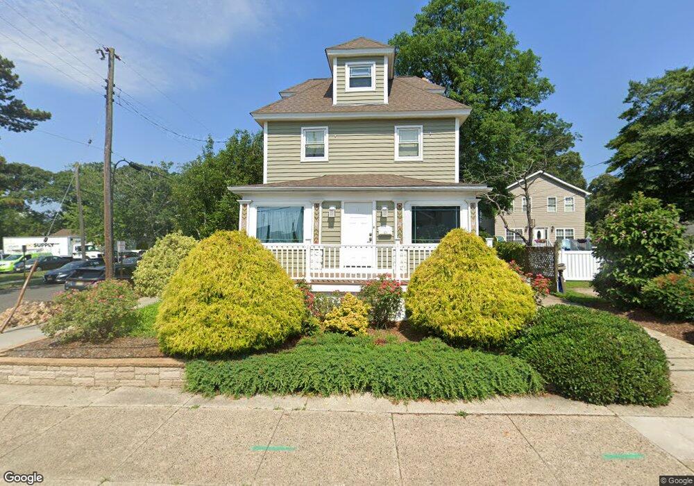
429 Shore Rd Somers Point, NJ 08244
Estimated Value: $423,673 - $499,000
--
Bed
--
Bath
1,877
Sq Ft
$244/Sq Ft
Est. Value
About This Home
This home is located at 429 Shore Rd, Somers Point, NJ 08244 and is currently estimated at $457,918, approximately $243 per square foot. 429 Shore Rd is a home located in Atlantic County with nearby schools including Mainland Regional High School, ChARTer TECH High School for the Performing Arts, and Saint Joseph Regional School.
Ownership History
Date
Name
Owned For
Owner Type
Purchase Details
Closed on
Jul 30, 1993
Sold by
Feldbauer Thomas B and Mary Jo
Bought by
Myers Daniel R and Myers Alice M
Current Estimated Value
Purchase Details
Closed on
Jan 12, 1990
Sold by
Feldbauer Thomas B and Feldbauer Donald J
Bought by
Feldbauer Thomas B and Mary Jo
Purchase Details
Closed on
Dec 29, 1989
Sold by
Feldbauer Donald J and Feldbauer Betty
Bought by
Feldbauer Thomas B and Feldbauer Donald J
Create a Home Valuation Report for This Property
The Home Valuation Report is an in-depth analysis detailing your home's value as well as a comparison with similar homes in the area
Home Values in the Area
Average Home Value in this Area
Purchase History
| Date | Buyer | Sale Price | Title Company |
|---|---|---|---|
| Myers Daniel R | $129,000 | -- | |
| Feldbauer Thomas B | -- | -- | |
| Feldbauer Thomas B | -- | -- |
Source: Public Records
Tax History Compared to Growth
Tax History
| Year | Tax Paid | Tax Assessment Tax Assessment Total Assessment is a certain percentage of the fair market value that is determined by local assessors to be the total taxable value of land and additions on the property. | Land | Improvement |
|---|---|---|---|---|
| 2025 | $8,379 | $234,300 | $60,500 | $173,800 |
| 2024 | $8,379 | $234,300 | $60,500 | $173,800 |
| 2023 | $7,828 | $234,300 | $60,500 | $173,800 |
| 2022 | $7,828 | $234,300 | $60,500 | $173,800 |
| 2021 | $7,711 | $234,300 | $60,500 | $173,800 |
| 2020 | $7,554 | $234,300 | $60,500 | $173,800 |
| 2019 | $7,341 | $234,300 | $60,500 | $173,800 |
| 2018 | $7,640 | $249,100 | $60,500 | $188,600 |
| 2017 | $7,366 | $249,100 | $60,500 | $188,600 |
| 2016 | $7,032 | $249,100 | $60,500 | $188,600 |
| 2015 | $6,960 | $249,100 | $60,500 | $188,600 |
| 2014 | $6,726 | $249,100 | $60,500 | $188,600 |
Source: Public Records
Map
Nearby Homes
- 421 Shore Rd
- 109 E Cedar Ave
- 101 E Johnson Ave
- 123 E Cedar Ave
- 25 W Pierson Ave
- 29 E Pierson Ave
- 112 E Pierson Ave
- 1020 Pleasant Ave
- 1013 Pleasant Ave
- 1014 Pleasant Ave
- 1024 Pleasant Ave
- 1015 Pleasant Ave
- 114 E Pierson Ave
- 137 W Johnson Ave
- 1002 Pleasant Ave
- 1102 Jesse Dr
- 2102 Angelina Ln
- 1803 Pleasant Ave
- 33 W Meyran Ave
- 118 E Wilmont Ave
- 427 Shore Rd
- 15 W Groveland Ave
- 419 Shore Rd
- 426 Shore Rd
- 426 Shore Rd Unit E
- 14 W Groveland Ave
- 23 W Groveland Ave
- 415 Shore Rd
- 20 W Groveland Ave
- 416 Shore Rd
- 24 E Groveland Ave
- 24 W Groveland Ave
- 25 W Groveland Ave
- 410 Shore Rd
- 28 W Groveland Ave
- 12 E Groveland Ave
- 438 Shore Rd
- 408 Shore Rd
- 19 E Groveland Ave
- 15 W Maryland Ave