
Seller's Agent in 2025
Connie Huang
Coldwell Banker Residential Brokerage - Princeton
(609) 731-7617
13 in this area
40 Total Sales
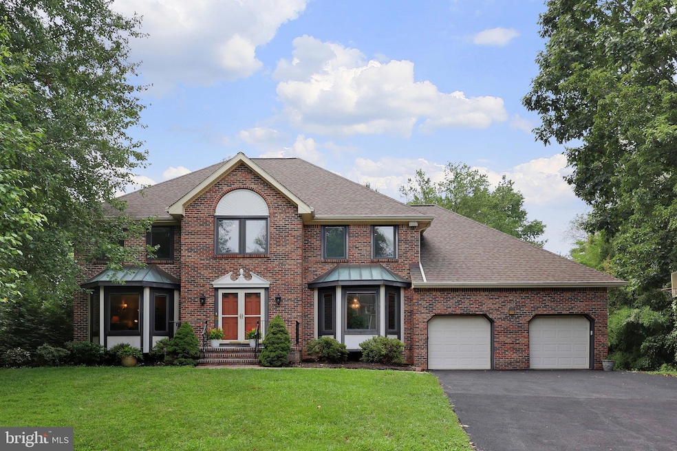
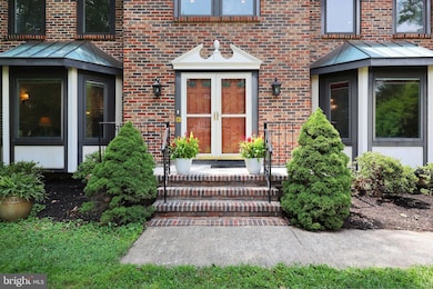
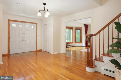
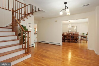
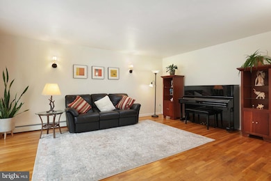
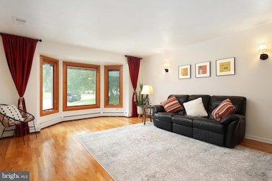
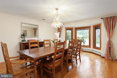
Welcome to this beautifully maintained custom-built Colonial, ideally located on a quiet cul-de-sac and just steps away from the Princeton Junction train station—perfect for commuters seeking both convenience and tranquility. The main floor offers a spacious and flowing layout, including a generously sized living room and formal dining room, ideal for gatherings and entertaining. The family room features a wood-burning fireplace and sliding glass doors that open to a private deck overlooking a serene wooded area, creating a peaceful indoor-outdoor retreat.
The gourmet kitchen features granite counter tops and stainless steel appliances. Dish washer, stove, refrigerator and laundry room washer are less than 2 years old.
Brand new tile flooring in the kitchen, breakfast area, and laundry room, adding a fresh and modern touch. A completely renovated half-bath and a private office complete the first floor, offering space for both comfort and productivity. Upstairs, the expansive primary suite includes walk in closet, jacuzzi tub, brand new double vanities and stall shower with a brand new glass shower door, providing a relaxing escape. The second bathroom also features a brand new vanity and commode. Gleaming hardwood floors throughout and freshly painted interior, enhancing the warmth and elegance of every room. Energy efficient Pella windows with roll up screens and interior blinds(except office& two bedrooms) . Full basement with French drain. Brand new driveway and front porch. Close to shopping, restaurants, major highways, and within the top-rated West Windsor-Plainsboro School District. Don’t miss your chance to own this move-in-ready gem in the most desirable Benford Estates community!
Last Agent to Sell the Property
(609) 731-7617 connie.huang@cbmoves.com Coldwell Banker Residential Brokerage - Princeton Listed on: 07/26/2025
| Date | Type | Sale Price | Title Company |
|---|---|---|---|
| Bargain Sale Deed | $1,025,000 | Trident Land Transfer | |
| Deed | $90,000 | Acres Land Title Agency Inc | |
| Deed | -- | -- | |
| Deed | $480,000 | -- | |
| Deed | $345,000 | -- |
| Date | Status | Loan Amount | Loan Type |
|---|---|---|---|
| Previous Owner | -- | No Value Available | |
| Previous Owner | $382,000 | Purchase Money Mortgage |
| Date | Event | Price | List to Sale | Price per Sq Ft |
|---|---|---|---|---|
| 09/25/2025 09/25/25 | Sold | $1,025,000 | -6.0% | $346 / Sq Ft |
| 08/13/2025 08/13/25 | Price Changed | $1,090,000 | -2.6% | $368 / Sq Ft |
| 07/26/2025 07/26/25 | For Sale | $1,119,000 | -- | $378 / Sq Ft |
| Year | Tax Paid | Tax Assessment Tax Assessment Total Assessment is a certain percentage of the fair market value that is determined by local assessors to be the total taxable value of land and additions on the property. | Land | Improvement |
|---|---|---|---|---|
| 2025 | $19,285 | $629,200 | $224,200 | $405,000 |
| 2024 | $18,480 | $629,200 | $224,200 | $405,000 |
| 2023 | $18,480 | $629,200 | $224,200 | $405,000 |
| 2022 | $18,121 | $629,200 | $224,200 | $405,000 |
| 2021 | $17,970 | $629,200 | $224,200 | $405,000 |
| 2020 | $17,643 | $629,200 | $224,200 | $405,000 |
| 2019 | $17,441 | $629,200 | $224,200 | $405,000 |
| 2018 | $17,278 | $629,200 | $224,200 | $405,000 |
| 2017 | $16,919 | $629,200 | $224,200 | $405,000 |
| 2016 | $16,554 | $629,200 | $224,200 | $405,000 |
| 2015 | $16,170 | $629,200 | $224,200 | $405,000 |
| 2014 | $15,982 | $629,200 | $224,200 | $405,000 |
Seller's Agent in 2025
Connie Huang
Coldwell Banker Residential Brokerage - Princeton
(609) 731-7617
13 in this area
40 Total Sales
Buyer's Agent in 2025
Shani Dixon
BHHS Fox & Roach
(609) 635-8890
9 in this area
56 Total Sales
Source: Bright MLS
MLS Number: NJME2063154
APN: 13-00082-0000-00014
Disclaimer: Certain information contained herein is derived from information provided by parties other than Homes.com. All information provided is deemed reliable, but is not guaranteed to be accurate and should be independently verified.
![]() The data relating to real estate for sale on this website appears in part through the BRIGHT Internet Data Exchange program, a voluntary cooperative exchange of property listing data between licensed real estate brokerage firms, and is provided by BRIGHT through a licensing agreement.
The data relating to real estate for sale on this website appears in part through the BRIGHT Internet Data Exchange program, a voluntary cooperative exchange of property listing data between licensed real estate brokerage firms, and is provided by BRIGHT through a licensing agreement.
Listing information is from various brokers who participate in the Bright MLS IDX program and not all listings may be visible on the site.
The property information being provided on or through the website is for the personal, non-commercial use of consumers and such information may not be used for any purpose other than to identify prospective properties consumers may be interested in purchasing.
Some properties which appear for sale on the website may no longer be available because they are for instance, under contract, sold or are no longer being offered for sale.
Property information displayed is deemed reliable but is not guaranteed.
Copyright 2025 Bright MLS, Inc.