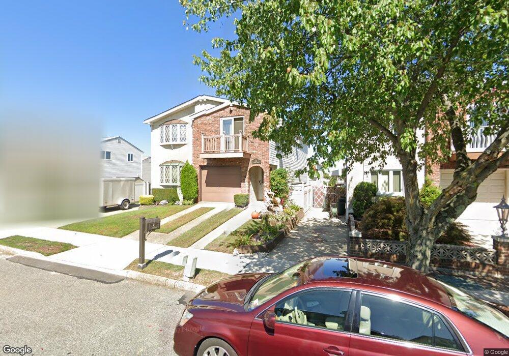
43 E Macon Ave Staten Island, NY 10308
Great Kills NeighborhoodEstimated Value: $801,036 - $974,000
--
Bed
--
Bath
2,300
Sq Ft
$400/Sq Ft
Est. Value
About This Home
This home is located at 43 E Macon Ave, Staten Island, NY 10308 and is currently estimated at $919,259, approximately $399 per square foot. 43 E Macon Ave is a home located in Richmond County with nearby schools including P.S. 32 The Gifford School, I.S. 075 Frank D. Paulo, and Susan E Wagner High School.
Ownership History
Date
Name
Owned For
Owner Type
Purchase Details
Closed on
Jun 1, 2022
Sold by
Umschweif Joyce M
Bought by
Umschweif Joyce M and Umschweif Stephen T
Current Estimated Value
Purchase Details
Closed on
Nov 13, 2002
Sold by
Reinhardt Stanley
Bought by
Umschweif A Stuart and Umschweif Joyce M
Home Financials for this Owner
Home Financials are based on the most recent Mortgage that was taken out on this home.
Original Mortgage
$180,000
Interest Rate
6.09%
Mortgage Type
Purchase Money Mortgage
Create a Home Valuation Report for This Property
The Home Valuation Report is an in-depth analysis detailing your home's value as well as a comparison with similar homes in the area
Home Values in the Area
Average Home Value in this Area
Purchase History
| Date | Buyer | Sale Price | Title Company |
|---|---|---|---|
| Umschweif Joyce M | -- | Law Office Of Jack Stern | |
| Umschweif A Stuart | $14,500 | Old Republic Natl Title Ins |
Source: Public Records
Mortgage History
| Date | Status | Borrower | Loan Amount |
|---|---|---|---|
| Previous Owner | Umschweif A Stuart | $180,000 |
Source: Public Records
Tax History Compared to Growth
Tax History
| Year | Tax Paid | Tax Assessment Tax Assessment Total Assessment is a certain percentage of the fair market value that is determined by local assessors to be the total taxable value of land and additions on the property. | Land | Improvement |
|---|---|---|---|---|
| 2025 | $3,393 | $51,600 | $9,529 | $42,071 |
| 2024 | $3,497 | $47,640 | $9,903 | $37,737 |
| 2023 | $3,377 | $39,744 | $8,262 | $31,482 |
| 2022 | $4,285 | $44,580 | $11,400 | $33,180 |
| 2021 | $4,205 | $40,920 | $11,400 | $29,520 |
| 2020 | $5,047 | $37,140 | $11,400 | $25,740 |
| 2019 | $4,752 | $38,520 | $11,400 | $27,120 |
| 2018 | $6,454 | $33,120 | $10,401 | $22,719 |
| 2017 | $6,172 | $31,748 | $10,207 | $21,541 |
| 2016 | $5,678 | $29,952 | $10,144 | $19,808 |
| 2015 | $5,210 | $29,952 | $8,511 | $21,441 |
| 2014 | $5,210 | $28,740 | $9,480 | $19,260 |
Source: Public Records
Map
Nearby Homes
- 26 E Brandis Ave
- 350 Brookfield Ave
- 74 E Brandis Ave
- 339 Abingdon Ave
- 379 Brookfield Ave
- 919 Armstrong Ave
- 259 Brookfield Ave
- 307 Abingdon Ave
- 466 Doane Ave
- 924 Armstrong Ave Unit 2-3
- 345 Colon Ave
- 414 Elverton Ave
- 72 Eric Ln
- 88 Cortelyou Ave
- 12 Lexington Ln
- 131 Cortelyou Ave Unit 1-1
- 443 Ridgewood Ave
- 467 Ridgewood Ave
- 248 Abingdon Ave
- 185 Brookfield Ave
- 41 E Macon Ave
- 997 Armstrong Ave
- 999 Armstrong Ave
- 993 Armstrong Ave
- 35 E Macon Ave
- 1001 Armstrong Ave
- 36 E Brandis Ave
- 40 E Brandis Ave
- 34 E Brandis Ave
- 1005 Armstrong Ave
- 30 E Brandis Ave
- 29 E Macon Ave
- 981 Armstrong Ave
- 24 E Brandis Ave
- 1011 Armstrong Ave
- 25 E Macon Ave
- 40 E Macon Ave
- 20 E Brandis Ave
- 34 E Macon Ave
- 977 Armstrong Ave