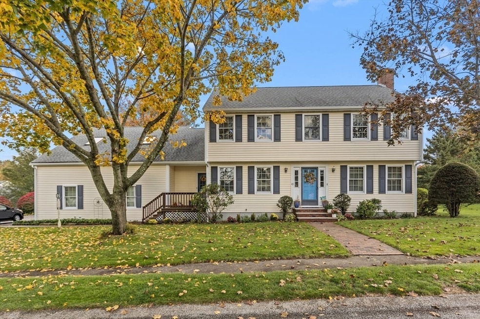
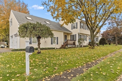
43 Flint Locke Dr East Weymouth, MA 02189
East Weymouth NeighborhoodEstimated payment $5,448/month
Highlights
- Marina
- Colonial Architecture
- Property is near public transit
- Above Ground Pool
- Deck
- Wood Flooring
About This Home
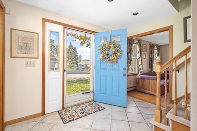
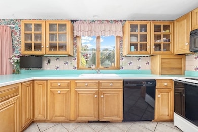
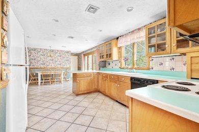
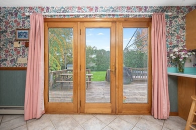
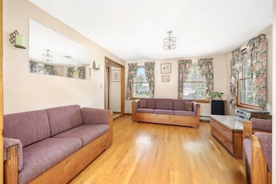
Welcome to 43 Flint Locke Drive—a beautifully maintained property nestled in one of Weymouth's most desirable neighborhoods. Proudly offered for the first time in 33 years this single-family residence presents an exceptional opportunity to establish roots in the sought-after Paul Revere Estates. From the moment you arrive, you'll notice the pride of ownership reflected in the home's manicured lawn and charming curb appeal. The expansive backyard is perfect for limitless outdoor use. Inside, the generous floor plan provides endless possibilities. The light, bright kitchen is a perfect gathering space. Off the kitchen you will find an additional room boasting hardwood floors ideal for dining, office use, or whatever suites your needs. Upstairs are four spacious bedrooms, full bathroom and huge bonus room. A walk-up attic completes the second floor. While the heated two-car garage offers even more space. Don't miss the opportunity to bring your own personal touch to this well-loved home.
Listing Agent
Coldwell Banker Realty - Norwell - Hanover Regional Office Listed on: 10/23/2025

Home Details
Home Type
- Single Family
Est. Annual Taxes
- $9,720
Year Built
- Built in 1992
Lot Details
- 0.4 Acre Lot
- Level Lot
- Sprinkler System
- Property is zoned R-5
Parking
- 2 Car Attached Garage
- Heated Garage
- Side Facing Garage
- Garage Door Opener
- Driveway
- Open Parking
- Off-Street Parking
Home Design
- Colonial Architecture
- Frame Construction
- Shingle Roof
- Concrete Perimeter Foundation
Interior Spaces
- 2,672 Sq Ft Home
- Ceiling Fan
- Living Room with Fireplace
- Dining Area
- Unfinished Basement
- Block Basement Construction
- Attic Access Panel
Kitchen
- Breakfast Bar
- Range
- Microwave
- Dishwasher
Flooring
- Wood
- Wall to Wall Carpet
- Ceramic Tile
Bedrooms and Bathrooms
- 4 Bedrooms
- Primary bedroom located on second floor
- Walk-In Closet
- 2 Full Bathrooms
Laundry
- Laundry on main level
- Dryer
- Washer
Outdoor Features
- Above Ground Pool
- Bulkhead
- Deck
- Outdoor Storage
- Rain Gutters
- Porch
Location
- Property is near public transit
- Property is near schools
Schools
- Wesagusset Elementary School
- Maria Chapman Middle School
- Weymouth High School
Utilities
- Central Air
- 1 Cooling Zone
- 4 Heating Zones
- Heating System Uses Oil
- Electric Water Heater
Listing and Financial Details
- Assessor Parcel Number M:11 B:121 L:109,271465
Community Details
Overview
- No Home Owners Association
- Paul Revere Estates Subdivision
Amenities
- Shops
Recreation
- Marina
- Jogging Path
Map
Home Values in the Area
Average Home Value in this Area
Tax History
| Year | Tax Paid | Tax Assessment Tax Assessment Total Assessment is a certain percentage of the fair market value that is determined by local assessors to be the total taxable value of land and additions on the property. | Land | Improvement |
|---|---|---|---|---|
| 2025 | $9,720 | $962,400 | $262,200 | $700,200 |
| 2024 | $9,417 | $916,900 | $249,800 | $667,100 |
| 2023 | $8,596 | $822,600 | $231,300 | $591,300 |
| 2022 | $8,381 | $731,300 | $214,200 | $517,100 |
| 2021 | $7,903 | $673,200 | $214,200 | $459,000 |
| 2020 | $7,607 | $638,200 | $214,200 | $424,000 |
| 2019 | $7,480 | $617,200 | $205,900 | $411,300 |
| 2018 | $7,206 | $576,500 | $196,100 | $380,400 |
| 2017 | $7,037 | $549,300 | $186,800 | $362,500 |
| 2016 | $7,014 | $548,000 | $179,600 | $368,400 |
| 2015 | $6,631 | $514,000 | $179,600 | $334,400 |
| 2014 | $6,492 | $488,100 | $174,100 | $314,000 |
Property History
| Date | Event | Price | List to Sale | Price per Sq Ft |
|---|---|---|---|---|
| 11/15/2025 11/15/25 | Pending | -- | -- | -- |
| 11/15/2025 11/15/25 | For Sale | $879,900 | 0.0% | $329 / Sq Ft |
| 11/04/2025 11/04/25 | Pending | -- | -- | -- |
| 10/23/2025 10/23/25 | For Sale | $879,900 | -- | $329 / Sq Ft |
Purchase History
| Date | Type | Sale Price | Title Company |
|---|---|---|---|
| Leasehold Conv With Agreement Of Sale Fee Purchase Hawaii | $70,000 | -- |
Mortgage History
| Date | Status | Loan Amount | Loan Type |
|---|---|---|---|
| Closed | $120,000 | No Value Available |
Source: MLS Property Information Network (MLS PIN)
MLS Number: 73447261
APN: WEYM-000011-000121-000109
Disclaimer: Certain information contained herein is derived from information provided by parties other than Homes.com. All information provided is deemed reliable, but is not guaranteed to be accurate and should be independently verified.
![]() The property listing data and information, or the Images, set forth herein were provided to MLS Property Information Network, Inc. from third party sources, including sellers, lessors and public records, and were compiled by MLS Property Information Network, Inc. The property listing data and information, and the Images, are for the personal, non-commercial use of consumers having a good faith interest in purchasing or leasing listed properties of the type displayed to them and may not be used for any purpose other than to identify prospective properties which such consumers may have a good faith interest in purchasing or leasing. MLS Property Information Network, Inc. and its subscribers disclaim any and all representations and warranties as to the accuracy of the property listing data and information, or as to the accuracy of any of the Images, set forth herein.
The property listing data and information, or the Images, set forth herein were provided to MLS Property Information Network, Inc. from third party sources, including sellers, lessors and public records, and were compiled by MLS Property Information Network, Inc. The property listing data and information, and the Images, are for the personal, non-commercial use of consumers having a good faith interest in purchasing or leasing listed properties of the type displayed to them and may not be used for any purpose other than to identify prospective properties which such consumers may have a good faith interest in purchasing or leasing. MLS Property Information Network, Inc. and its subscribers disclaim any and all representations and warranties as to the accuracy of the property listing data and information, or as to the accuracy of any of the Images, set forth herein.
- 320 Green St
- 59 Katherine St
- 2 Winstead Rd
- 20 Richards Rd
- 30 Puritan Rd
- 669 Commercial St
- 109 Merryknoll Rd
- 65 Saning Rd
- 51 Beals St Unit 53
- 88 Saning Rd
- 425 East St
- 16 Howard St
- 95 Fuller Rd
- 114 Gilbert Rd
- 14 Crescent Rd
- 21 Athens St Unit 11
- 56 Putnam St
- 70 Biscayne Ave
- 29-31 Broad Street Place
- 38 Idlewell St