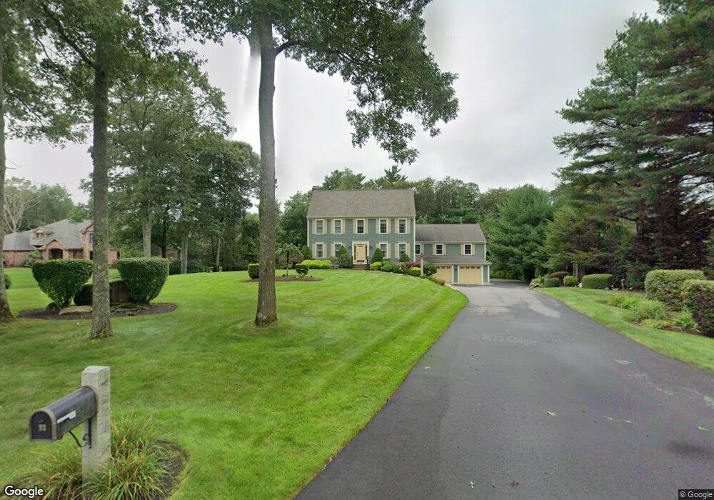
43 Highridge Rd Westport, MA 02790
Estimated Value: $917,906 - $1,246,000
3
Beds
--
Bath
3,342
Sq Ft
$319/Sq Ft
Est. Value
About This Home
This home is located at 43 Highridge Rd, Westport, MA 02790 and is currently estimated at $1,067,477, approximately $319 per square foot. 43 Highridge Rd is a home located in Bristol County with nearby schools including Alice A. Macomber Primary School, Westport Elementary School, and Westport Middle-High School.
Ownership History
Date
Name
Owned For
Owner Type
Purchase Details
Closed on
Feb 10, 2016
Sold by
Kozak Karl A and Kozak Diane E
Bought by
Highridge Road Rt
Current Estimated Value
Purchase Details
Closed on
Nov 25, 1992
Sold by
Cer Rt
Bought by
Kozak Karl A and Kozak Diane E
Create a Home Valuation Report for This Property
The Home Valuation Report is an in-depth analysis detailing your home's value as well as a comparison with similar homes in the area
Home Values in the Area
Average Home Value in this Area
Purchase History
| Date | Buyer | Sale Price | Title Company |
|---|---|---|---|
| Highridge Road Rt | -- | -- | |
| Kozak Karl A | $85,000 | -- |
Source: Public Records
Mortgage History
| Date | Status | Borrower | Loan Amount |
|---|---|---|---|
| Previous Owner | Kozak Karl A | $140,000 | |
| Previous Owner | Kozak Karl A | $24,332 |
Source: Public Records
Tax History Compared to Growth
Tax History
| Year | Tax Paid | Tax Assessment Tax Assessment Total Assessment is a certain percentage of the fair market value that is determined by local assessors to be the total taxable value of land and additions on the property. | Land | Improvement |
|---|---|---|---|---|
| 2025 | $5,450 | $731,500 | $296,200 | $435,300 |
| 2024 | $5,236 | $677,300 | $251,800 | $425,500 |
| 2023 | $5,392 | $660,800 | $241,900 | $418,900 |
| 2022 | $5,056 | $596,200 | $225,200 | $371,000 |
| 2021 | $4,994 | $579,300 | $208,300 | $371,000 |
| 2020 | $4,827 | $572,600 | $201,600 | $371,000 |
| 2019 | $4,725 | $571,300 | $216,500 | $354,800 |
| 2018 | $4,707 | $576,100 | $195,300 | $380,800 |
| 2017 | $4,627 | $580,500 | $195,300 | $385,200 |
| 2016 | $3,991 | $504,600 | $195,300 | $309,300 |
| 2015 | $3,906 | $492,600 | $199,000 | $293,600 |
Source: Public Records
Map
Nearby Homes
- 73 White Oak Run
- 47 Fallon Dr
- 0 Hidden Glen Ln
- 118 Charlotte White Rd Extension
- Lot 0 Marcotte
- 920 Drift Rd
- 8 Strawberry Ln
- 225 Hixbridge Rd
- 2 Slades Farm Ln
- 118 Charlotte White Rd
- 7 Village Way
- 8 Village Way
- 837 Main Rd
- 15 Village Way
- 4 Main Rd
- 1150 Russells Mills Rd
- 3 Roller Coaster Way Unit Lot 1
- 101 Adamsville Rd
- 27 Dias Ave
- 461 Reed Rd
- 37 Highridge Rd
- 49 Highridge Rd
- 0 Highridge Rd
- 1T Highridge Rd
- 46 Highridge Rd
- 31 Highridge Rd
- 55 Highridge Rd
- 40 Highridge Rd
- 52 Highridge Rd
- 25 Highridge Rd
- 61 Highridge Rd
- 58 Highridge Rd
- 34 Highridge Rd
- 26 Highridge Rd
- 67 Highridge Rd
- 1 Highridge Rd
- 64 Highridge Rd
- 20 Highridge Rd
- 70 Highridge Rd
- 73 Highridge Rd