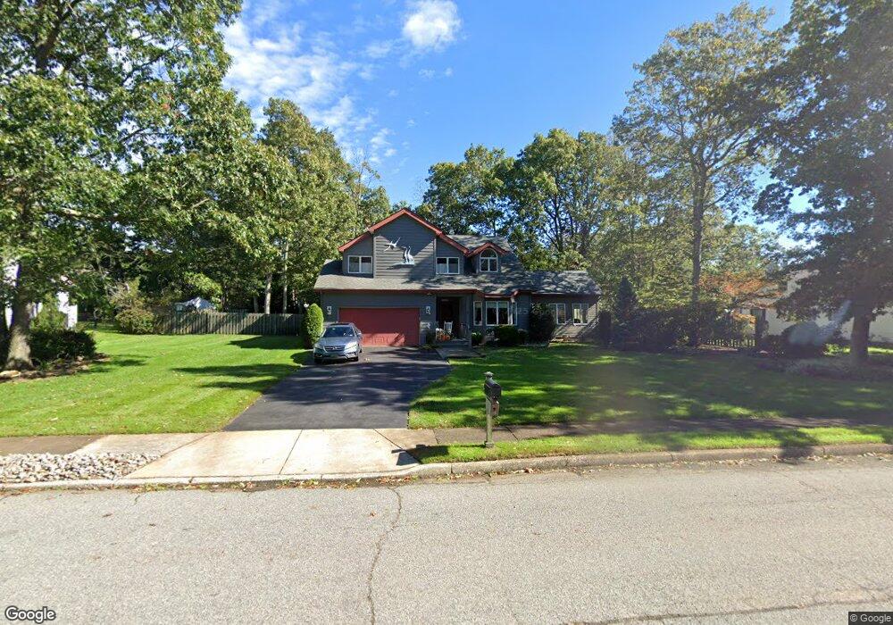
43 Jill Ave Marmora, NJ 08223
Estimated Value: $526,101 - $644,000
--
Bed
--
Bath
2,204
Sq Ft
$257/Sq Ft
Est. Value
About This Home
This home is located at 43 Jill Ave, Marmora, NJ 08223 and is currently estimated at $566,775, approximately $257 per square foot. 43 Jill Ave is a home located in Cape May County with nearby schools including Upper Township Primary School, Upper Township Elementary School, and Upper Township Middle School.
Ownership History
Date
Name
Owned For
Owner Type
Purchase Details
Closed on
Apr 4, 2024
Sold by
Baker Larry D and Baker Krlstina S
Bought by
Larry D Baker And Icrlstina Baker Irrevocable and Baker
Current Estimated Value
Purchase Details
Closed on
Aug 18, 1994
Sold by
Cori Joseph
Bought by
Baker Larry D and Baker Kristina
Home Financials for this Owner
Home Financials are based on the most recent Mortgage that was taken out on this home.
Original Mortgage
$65,000
Interest Rate
8.65%
Create a Home Valuation Report for This Property
The Home Valuation Report is an in-depth analysis detailing your home's value as well as a comparison with similar homes in the area
Home Values in the Area
Average Home Value in this Area
Purchase History
| Date | Buyer | Sale Price | Title Company |
|---|---|---|---|
| Larry D Baker And Icrlstina Baker Irrevocable | -- | None Listed On Document | |
| Larry D Baker And Icrlstina Baker Irrevocable | -- | None Listed On Document | |
| Baker Larry D | $190,000 | -- |
Source: Public Records
Mortgage History
| Date | Status | Borrower | Loan Amount |
|---|---|---|---|
| Previous Owner | Baker Larry D | $65,000 |
Source: Public Records
Tax History Compared to Growth
Tax History
| Year | Tax Paid | Tax Assessment Tax Assessment Total Assessment is a certain percentage of the fair market value that is determined by local assessors to be the total taxable value of land and additions on the property. | Land | Improvement |
|---|---|---|---|---|
| 2025 | $7,422 | $334,300 | $136,900 | $197,400 |
| 2024 | $7,422 | $334,300 | $136,900 | $197,400 |
| 2023 | $7,044 | $334,300 | $136,900 | $197,400 |
| 2022 | $6,777 | $334,300 | $136,900 | $197,400 |
| 2021 | $4,828 | $334,300 | $136,900 | $197,400 |
| 2020 | $5,753 | $308,000 | $136,900 | $171,100 |
| 2019 | $5,593 | $308,000 | $136,900 | $171,100 |
| 2018 | $5,439 | $308,000 | $136,900 | $171,100 |
| 2017 | $5,368 | $308,000 | $136,900 | $171,100 |
| 2016 | $5,118 | $289,400 | $136,900 | $152,500 |
| 2015 | $4,974 | $289,400 | $136,900 | $152,500 |
| 2014 | $5,591 | $396,800 | $204,100 | $192,700 |
Source: Public Records
Map
Nearby Homes
- 24 E Timber Dr
- 734 Stagecoach Rd
- 705 Route Us 9 S
- 430 S Shore Rd
- 731 Oceancrest Ave
- 246 Egret Ln
- 11 Evio John Ct
- 46 Victoria Ln
- 4 Bayview Ave
- 19 Bayview Ave
- 100 Bayview Ave
- 14 Roberts Ave
- 11 Red Oak Dr
- 124 Butter Rd
- 1 Roosevelt Blvd
- 40 Butter Rd
- 14 Lyndhurst Rd
- 32 Norwood Rd
- 1233 Route 9
- 125 N Shore Rd