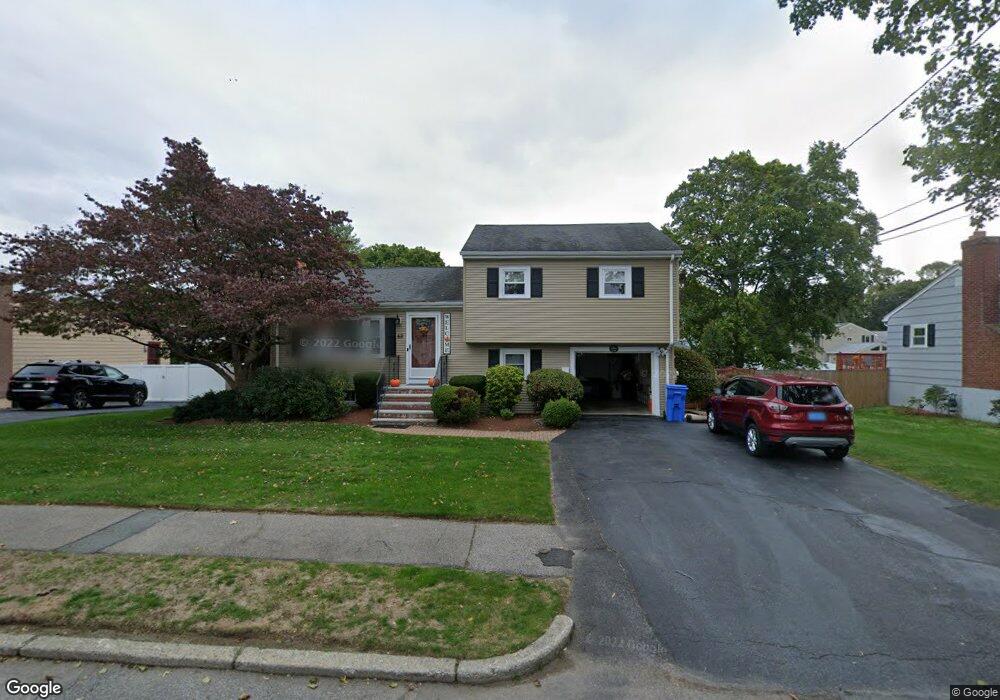
43 Miriam Rd Waltham, MA 02451
North Waltham NeighborhoodEstimated Value: $828,880 - $982,000
3
Beds
2
Baths
1,556
Sq Ft
$579/Sq Ft
Est. Value
About This Home
This home is located at 43 Miriam Rd, Waltham, MA 02451 and is currently estimated at $900,470, approximately $578 per square foot. 43 Miriam Rd is a home located in Middlesex County with nearby schools including Douglas Macarthur Elementary School, John F Kennedy Middle School, and Waltham Sr High School.
Ownership History
Date
Name
Owned For
Owner Type
Purchase Details
Closed on
Apr 25, 2017
Sold by
Evans Kimberly E and Daigle Gerard J
Bought by
Daigle Ft
Current Estimated Value
Purchase Details
Closed on
Jul 26, 2011
Sold by
43 Miriam Road Rt
Bought by
Reardon Kimberly E
Home Financials for this Owner
Home Financials are based on the most recent Mortgage that was taken out on this home.
Original Mortgage
$380,000
Interest Rate
4.49%
Mortgage Type
Purchase Money Mortgage
Purchase Details
Closed on
Jan 29, 2007
Sold by
Patricia M Murpy Ret
Bought by
43 Miriam Road Rt
Create a Home Valuation Report for This Property
The Home Valuation Report is an in-depth analysis detailing your home's value as well as a comparison with similar homes in the area
Home Values in the Area
Average Home Value in this Area
Purchase History
| Date | Buyer | Sale Price | Title Company |
|---|---|---|---|
| Daigle Ft | -- | -- | |
| Reardon Kimberly E | $475,000 | -- | |
| 43 Miriam Road Rt | -- | -- |
Source: Public Records
Mortgage History
| Date | Status | Borrower | Loan Amount |
|---|---|---|---|
| Previous Owner | Reardon Kimberly E | $380,000 |
Source: Public Records
Tax History
| Year | Tax Paid | Tax Assessment Tax Assessment Total Assessment is a certain percentage of the fair market value that is determined by local assessors to be the total taxable value of land and additions on the property. | Land | Improvement |
|---|---|---|---|---|
| 2025 | $7,509 | $764,700 | $456,500 | $308,200 |
| 2024 | $7,128 | $739,400 | $436,300 | $303,100 |
| 2023 | $7,061 | $684,200 | $395,900 | $288,300 |
| 2022 | $6,951 | $624,000 | $355,500 | $268,500 |
| 2021 | $6,876 | $607,400 | $355,500 | $251,900 |
| 2020 | $6,687 | $559,600 | $331,300 | $228,300 |
| 2019 | $7,033 | $555,500 | $327,200 | $228,300 |
| 2018 | $6,431 | $510,000 | $303,000 | $207,000 |
| 2017 | $6,050 | $481,700 | $274,700 | $207,000 |
| 2016 | $5,699 | $465,600 | $258,600 | $207,000 |
| 2015 | $5,406 | $411,700 | $226,200 | $185,500 |
Source: Public Records
Map
Nearby Homes
- 89 Hardy Pond Rd
- 1105 Lexington St Unit 6-4
- 7 Field Rd
- 33 Jacqueline Rd Unit D
- 14 Benjamin Rd
- 1393 Trapelo Rd
- 353 Concord Ave
- 44 Lakeview Terrace
- 9 April Ln Unit 9
- 14 Piedmont Ave
- 107 Clocktower Dr Unit 3302
- 63 Montclair Ave
- 28 Hillcrest St
- 23 Hillcrest St
- 11 Autumn Ln
- 45 Webster Rd
- 12 Wellington Lane Ave
- 34 Allen St
- 15 Cedarcroft Ln
- 345 Bishops Forest Dr
Your Personal Tour Guide
Ask me questions while you tour the home.